

(Sea-chart of Catalunia, Languedoc, Provence, Cote d'Azur, Riviera, Corsica with Marseille, Cannes, Nice, Monaco.)
This very rare chart is important as the first printed sea chart of France's Mediterranean coast, also depicting Catalunya's northern coast, the Italian Cote d'Azur till San Remo and Corsica's west coast.Willem Barentsz (1560-1597) was a famous pilot, discoverer and cartographer. Author of 'Nieuwe Beschrhryvinghe ende caertboeck van de Midlantsche Zee', the first printed pilot-guide of the Mediterranean. It is considered the supplement of Waghenaer's 'Spieghel der Zeevaerdt' for the Mediterranea...
€4.000
Maker : BARENTSZ, Willem.
Place : Amsterdam
Date : 1607
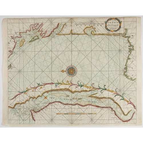
The Sea Coasts of France from Olone to Cape Machicaca in Biscay . . .
Detailed chart of Biscay Bay, showing the Coast of Brittany. The chart is oriented with north-east at the top and includes two large insets of the Loire River with Nantes and the complete coast of Brittany.Originally engraved by John Seller, here with the address "Sold by Ri. Mount at the Postern on Great Tower Hill LONDON". Mount and Page was a firm of religious and maritime publishers that flourished in the 18th century. The name became well-known worldwide as an imprint of nautical charts.The...
€550
Maker : MOUNT, R.. / PAGE, T.
Place : London
Date : ca. 1680
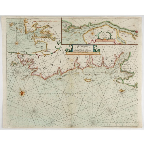
The Sea Coast of France from Ushent to Olone.
Chart showing the Brittany coast from Ushent to Ollone, with Belle-Ile. In insets : Rade de Brest and Mouth of the Loire between St. Nazaire and Nantes.Originally engraved by John Seller, here with the address "Sold by Ri. Mount at the Postern on Great Tower Hill LONDON". Mount and Page was a firm of religious and maritime publishers that flourished in the 18th century. The name became well-known worldwide as an imprint of nautical charts.The firm was founded in 1701 by Richard Mount (1654–172...
€550
Maker : MOUNT, R.. / PAGE, T.
Place : London, ca. 1680
Date : 1680
![[Lot of 5 maps of the mouth of the Gironde river] Carte des Entrees et Cours de la Gironde](/uploads/cache/86010-500x500.jpg)
[Lot of 5 maps of the mouth of the Gironde river] Carte des Entrees et Cours de la Gironde
A large sea chart of the mouth and course of the Gironde river as far inland as Bordeaux. Decorated with three cartouches.Jacques Nicolas Bellin (1702-720) was the most important French hydrographer of the 18th century. Sea-atlas 'Hydrographique Français' , 1756-65, atlas to accompany Prévost d' Exile's ' Histoire. des Voyages', 1738-75. A lot of 5 maps of the mouth of the Gironde river.- Carte des Entrees et Cours de la Gironde ((96x65 cm)- Carte du Gouvernent de Guyenne et Gascogne- Gou...
€350
Maker : BELLIN, J. N.
Place : Paris
Date : c. 1740