

Home
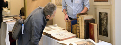
All about every Map Fair
Map-fair.com updates you about the Amsterdam, Paris, Venice, London, and Mantova map fairs. In addition, you will find info about book fairs, which include map dealers.
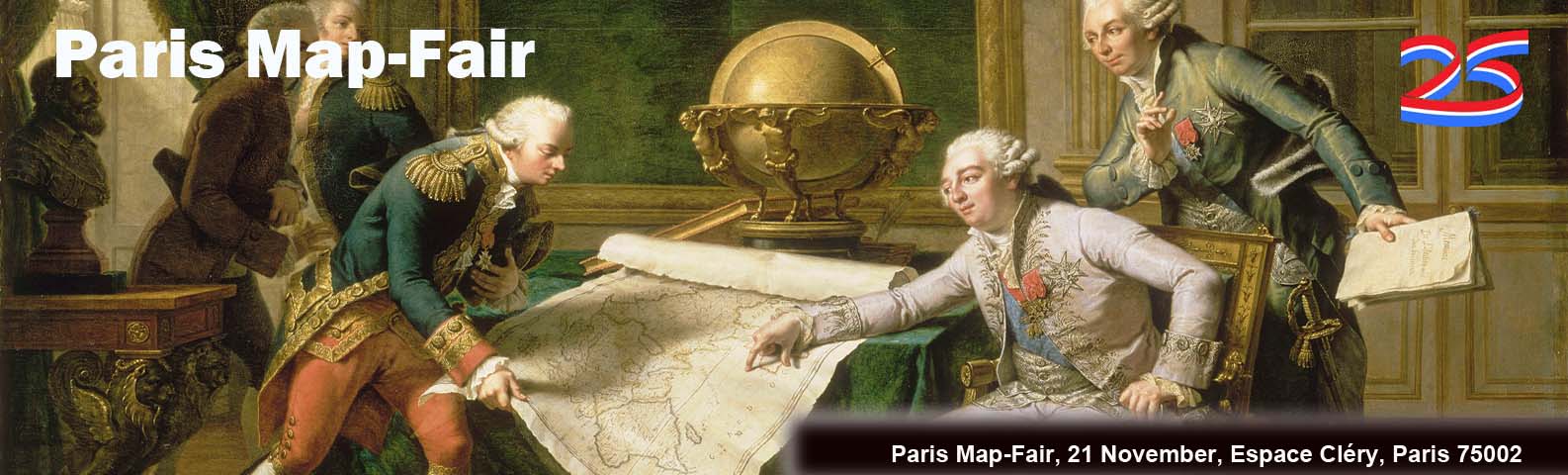
Paris Map Fair
21 November 2026
25th Edition. Twenty-three national and international map dealers. The fair is a one-day event. Free entry to the fair and lecture.
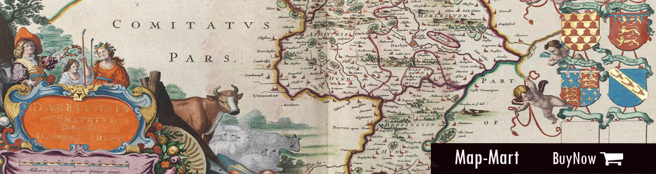
Map-Mart
This online catalog of fine and rare maps, sea charts, atlases, globes, prints, and atlases includes items provided by rare map dealers. All items are immediately available on a first-serve basis.

Amsterdam Map Fair
12 September 2026
The Third edition of the Amsterdam Map Fair will take place on 12 September, including thirty-three national and international map dealers. The fair is a one-day event, including lectures.

Map-Tube
The page presents videos about old maps, map collecting, map making, influential mapmakers, map dealers and map lecture registrations.
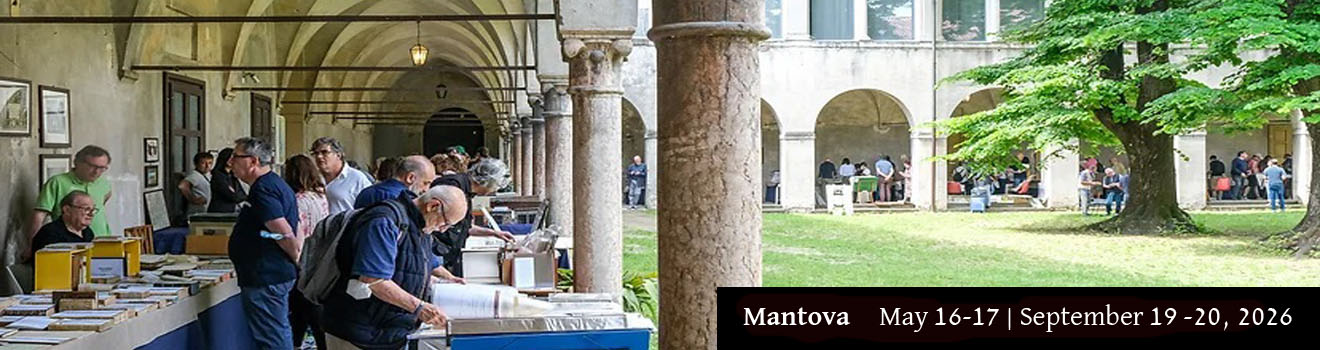
Venice Map Fair
March, 19,20 &21, 2027
The map fair is a 3-day event. 20 map dealers will show a good selection of Venice maps and Italy and all the world. A limited number of booths are still available.

London Map Fair
June 6 & 7, 2026
Royal Geographical Society, London, England. Forty national and some international map dealers show an extensive range of 16th to 20th-century maps. With lectures.
Map-Mart Catalog
The Map-Mart catalog offers a fine selection of maps, prints, charts, and atlases for immediate sale.
Contact us when you are a professional map dealer and want to list your items in the Map-Mart catalog.
Creating an account is easy, and start selling today.


.jpg)


Participating dealers at MapMart
-500x500.jpg)
Librairie Loeb-Larocque
The book shop Librairie Loeb-Larocque was founded in 1958 by Béatrice's
father Louis Loeb-Larocque. Originally he arrived in France from Germany
shortly after World War II. He first started an antiquarian map and
book shop in Paris. The shop was locat ...
Loeb-Larocque
France, Ile-de-France, Pris

Neatline Antique Maps
Michael Jennings received his Ph.D. with honors in Near Eastern
Languages and Civilizations from the University of Chicago. His
dissertation — “Beyond the Walls of Jericho: Khirbet al-Mafjar and the
Signature Landscapes of the Jericho Plain” — ...
Neatline_maps
United States, California, Tiburon

Trippini Studio Bibliografico
Sergio Trippini began in 1980 with collecting engravings about Italian lakes and, in 1988, decided to devote himself to their trade, extending his sphere of interests and knowledge. The subjects treated are Italian views in the form of single prints or bo ...
Trippini
Italy, VA, Gavirate

Paulus Swaen Old Maps
Paulus Swaen Inc. specializes in maps, atlases, globes, travel
posters, master prints and decorative prints from the 16th - 18th
century. We specialize in antique maps of all parts of the world,
produced by renowned cartographers, such as Ortelius...
Paulus_Swaen
United States, Florida, Clearwater

De Roo
Antiquariaat De Roo, based in Zwijndrecht (The Netherlands), was found in 2004 by Bart de Roo. We sell all kinds of old and rare books, our specialization is (fine) bindings, hand-colored works, religion, history, travel, exploration, and globes. Quality ...
De_Roo
Netherlands, Zwijndrecht

Papyro
Paryro beheert een collectie 16de-19de eeuwse zeekaarten en maritime tekeningen en prenten. Roland Boelen is ook eigenaar van "Ontzamelen", en wil u graag helpen bij het verkopen van uw kunst collectie.Ontzamelen is a company that can assist you when ...
Papyro
Netherlands, Amsterdam

Paul Bremmers Antiquariaat
Paul Bremmers Antiquariaat is in the center of Maastricht, a lovely city in the south of The Netherlands, right between Brussels and Cologne. We participate in several European fairs such as the Antiquarian Book and Print Fairs in Amsterdam, Paris, Mechel ...
Paul_Bremmers
Netherlands, Maastricht

Barry Lawrence Ruderman Antique Maps
We are dealers in fine and rare original antique maps and atlases dating from the 15th to 20th centuries.
Rare_Maps
United States, California, La Jolla
Recently Listed
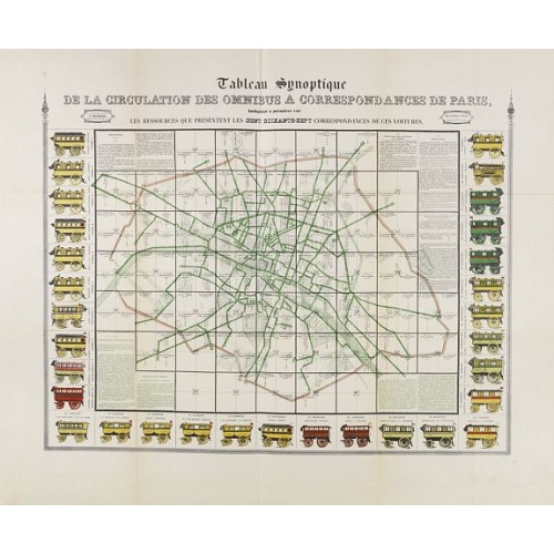
Tableau synoptique de la circulation des omnibus à correspondances de Paris.
Synoptic table of the circulation of omnibuses with connections of Paris indicating at first sight the resources presented by the one hundred and sixty-seven connections of these cars. Rare map of Paris divided into Grands Carrés showing omnibus stations and connections. The lines in green indicate the route of the bus lines. It is surrounded by 31 vignettes showing the different omnibuses: Omnibus, Constantines, Favorites, Tricycles, Diligentes, Citadines, Hirondelles, Parisiennes, Gazelles, ...
€750
Maker : RICHARD, V.
Place : Paris
Date : ca. 1854
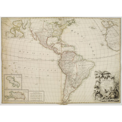
L'Amérique divisée en ses principaux Etats Dressée d'après les Cartes de Mr. Bonne
Rare, wall map of America in 2 sheets, after R. Bonne. With 3 inset maps of Hispaniola, Martinique and Hudson Bay. Beautiful title cartouche depicting a Native American leaning on a shell, under a palm tree, the figure is surrounded by typical elements of the flora and fauna of the continent as a beaver and 2 pelicans.
€5.500
Maker : BONNE, R. / LATTRÉ, J.
Place : Paris
Date : 1788
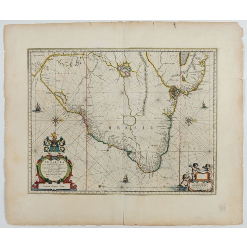
Brasilia.
Fine copy of this map by Krystof Arciszewski, a Polish general who worked for the Dutch West Indian Company. The map perpetuates various myths including the Parime Lago , although it is generally more accurate than its predecessors. Orientated with west to the top. Including the mouth of the Amazon.
€700
Maker : BLAEU, J.
Place : Amsterdam
Date : 1647
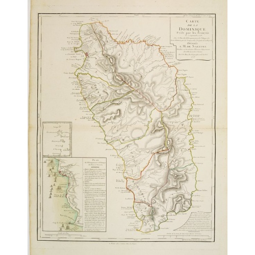
Carte de la Dominique Prise par les Francois le 7 Septembre 1778. Avec le Plan du Debarquement et de l'Attaque des Forts et Batteries par les Troupes et Les Fregates de sa Majeste
A rare map of St. Dominica, with insets of Charlotteville with its attack by the French on 7 September 1778 on the British. Also small inset map of the Caribbean islands from Antigua till Grenada. With dedication to de Sartine, a French official.
€500
Maker : BUACHE, S.
Place : Paris
Date : 1780
Featured Listings

A Map of the most Inhabited part of New England containing the Provinces of Massachusetts Bay and New Hampshire, with the Colonies of Connecticut and Rhode Island.
A copper engraving in four sheets, published in Georges Louis Le Rouge, in his "Atlas Ameriqua in Septentrional Contenant les details des differentes provinces, de ce vaste continent, traduit des cartes levées par ordre du Gouvernement Britannique". This is a very close copy of the second edition, the second issue of the Jefferys-Green map, even down to the spelling, in the statement of sources, of Connecticut with 'k's (but translated into French). The title cartouche is also a straight copy, ...
€4.000
Maker : LE ROUGE, G. L.
Place : Paris, 1777
Date : Paris, 1777
-500x500.jpg)
Hollandt: Hollandia quae olim Catthorum
One of the Earliest Printed Maps of Holland Produced in the Low Countries
$19.500
Maker : Cornelis de Hooghe
Place : Antwerp?
Date : 1565

(Sea-chart of Catalunia, Languedoc, Provence, Cote d'Azur, Riviera, Corsica with Marseille, Cannes, Nice, Monaco.)
This very rare chart is important as the first printed sea chart of France's Mediterranean coast, also depicting Catalunya's northern coast, the Italian Cote d'Azur till San Remo and Corsica's west coast.Willem Barentsz (1560-1597) was a famous pilot, discoverer and cartographer. Author of 'Nieuwe Beschrhryvinghe ende caertboeck van de Midlantsche Zee', the first printed pilot-guide of the Mediterranean. It is considered the supplement of Waghenaer's 'Spieghel der Zeevaerdt' for the Mediterranea...
€4.000
Maker : BARENTSZ, Willem.
Place : Amsterdam
Date : 1607
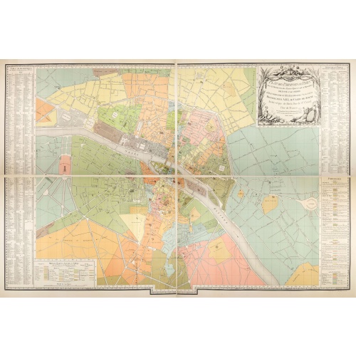
Plan des paroisses de Paris avec la distinction des parties éparses qui en dépendent dressé... par J. Junié, Ingén. Géogr. De Monseigneur l'Archeveque et géomètre des Eaux et forêts de ...
Large wall map size plan of Paris in 4 separate sheets, if joined forming a plan of Paris of 93 x 60cm. This plan is a 1904 version of a manuscript plan drawn in 1786 by Junié for A.-L. Le Clerc de Juigné.Published by Service des Travaux historiques de la Ville de Paris. To the left and right, a lettered key with a list of parishes with their boundaries and legends.Top right, title in an ornate cartouche: two women, symbolizing piety and justice, around the arms of LeClerc de Juigné (1728-1...
€750
Maker : JUNIÉ, J.
Place : Service des Travaux historiques de la Ville de Paris
Date : 1904

Zee caerte vande Sondt tvermaerste van Danemarcke . . .
A detailed chart of the coast of Denmark and its islands, Copenhagen in the center of the chart. West to the top. It is decorated by a title, scale and descriptive cartouche, a compass rose, several vessels and sea monsters, and depictions of mountains, fields, trees, small villages and animals.The chart shows soundings, sandbanks, landmarks and coastal profiles.Chart from an early Dutch text edition of this landmark contribution to the science of navigation. Waghenaer's own experiences as a pil...
$3.000
Maker : WAGHENAER, L. J.
Place : Leiden, Plantijn
Date : 1585

Europa recens descripta à Guilielmo Blaeuw.
On either side columns depicting the manner of dress in the major countries of Europe, surmounted by nine city views and plans.For European mapmakers their own continent contained few mysteries or secrets by the seventeenth century. However, the mythical island of Frisland still appears between Iceland and Greenland. The map is decorated with ships and a sea monster on the sea, bears on northern Russia, and lions on North Africa.
€3.250
Maker : BLAEU, W.
Place : Amsterdam
Date : 1644
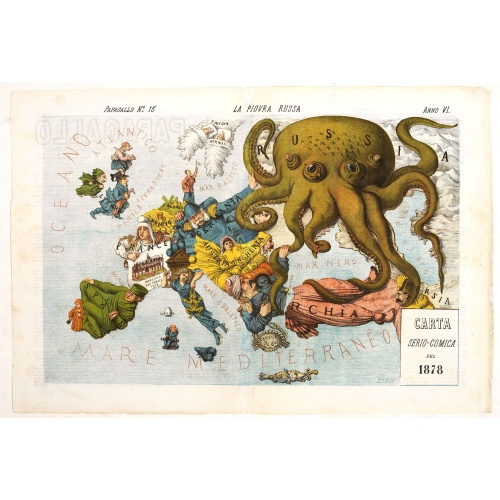
La Piovra Russa. Carta Serio-Comica Pel 1878.
Very rare political caricature map by Grossi of the nations of Europe, published in Bologna in the supplement of the newspaper "Le Perroquet / Al papagallo, N° 15, Anno VI.Known as the Octopus Map ; the brooding presence of the Russian Empire depicted as a massive octopus, whose tentacles stretch out towards Europe. In this map, the Octopus has Turkey, Persia and Poland but has been wounded by Crimea and is being fought off by Germany.This map, by Grossi, followed the style created by Frederick...
€1.850
Maker : GROSSI, A.
Place : Bologne
Date : 14 avril 1878
![A pair of extremely rare Valk table globes [GLOBES – TERRESTRIAL & CELESTIAL].](/uploads/cache/12345-500x500.jpg)
A pair of extremely rare Valk table globes [GLOBES – TERRESTRIAL & CELESTIAL].
A pair of extremely rare Valk table globes [GLOBES – TERRESTRIAL & CELESTIAL].VALK, Gerard and Leonard. [Terrestrial globe:] Cosmotheore, caelesti nostro globo, par, et plane novus, hic terrestris ut existeret, certo scias, errore veterum sublato, non tantum utriusque orbis, longitudines ac latitudines, par reiterates neotericorum observationes, hicce esse restitutas, sed et nullum typis emendatiorem prodiisse, hoc igitur novissimô tam diu fruere, donec sub majori forma, meô aere alios excud...
€275.000
Maker : VALK, L and G.
Place : Amsterdam
Date : 1700/1750
![(Chatelain "Atlas Historique" in 7 volumes.]](/uploads/cache/47053X-500x500.jpg)
(Chatelain "Atlas Historique" in 7 volumes.]
Henri Abraham Chatelain, whose Atlas Historique was one of the most expansive encyclopedias of the age. First published in 1705, Chatelain's Atlas Historique was part of an immense seven-volume encyclopedia. Although the main focus of the text was geography, the work also included a wealth of historical, political, and genealogical information. The text was compiled by Nicholas Gueudeville and Garillon with a supplement by H.P. de Limiers and the maps were engraved by Chatelain, primarily after...
€40.000
Maker : CHATELAIN, H.
Place : Amsterdam: Chez Zacharie Châtelain
Date : 1732 - 1739
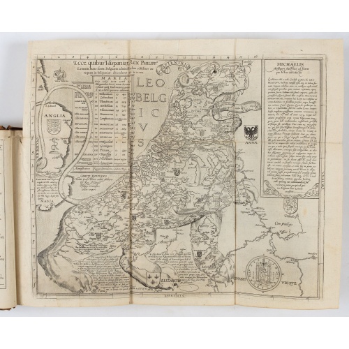
Novus de Leone Belgico eiusq topographia atq. Historica descriptione liber (…). Rerumque in Belgio maxime gestarum, inde ab anno Christi M.D.LIX. Usque ad annum M.D.LXXXVII perpetua narratione continatus.
ENLARGED EDITION, with 207 (of 208) engravings of a famous eyewitness account of the Dutch Revolt, with the famous "Leo Belgicus" map, here in its second state. One of the major sources for the history of the Low Countries during the beginning of their struggle for independence. This history of the religious wars in Belgium and Holland from 1559-87 is illustrated with Hogenberg's engravings (from his "Geschichtsblättern"), whereby the engravings for this edition were printed without the lower ...
$39.000
Maker : AITSINGER (EYZINGER), Michael von.
Place : Cologne, Gerardus Campensis for Frans Hogenberg
Date : 1588

Kaerte en Afbeeldinge vande Geheele Jurisdictie van Stantdarbuyten Gelegen in de Generaliteit onder Marquisaet van Bergen op den Zoom
With a large title cartouche with signature of the maker Adriaan van der Ende, : Kaerte en Afbeeldinge vande Geheele Jurisdictie van Stantdarbuyten Gelegen in de Generaliteit onder Marquisaet van Bergen op den Zoom, gemaekt, en in den Jare van 1733, 1734, 1735 gemeten by my ondergetz… Willemstadt den 8 Julij 1737 Adr: van Enden.Adriaan van de Ende was a surveyor, appointed by the Council of Brabant in 1720, then living in Heyningen. Was later living and active in Willemstad.Other manuscript m...
$2.500
Maker : VAN DE ENDEN, A.
Place : Willemstadt
Date : 1737