ID: 90
Open


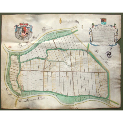
Kaerte en Afbeeldinge vande Geheele Jurisdictie van Stantdarbuyten Gelegen in de Generaliteit onder Marquisaet van Bergen op den Zoom
BuyNow for $2.500
- Maker :
- VAN DE ENDEN, A.
- Place :
- Willemstadt
- Date :
- 1737
- Color :
- In original color
- Height mm.:
- 810
- Width mm.:
- 1020
- Condition :
- Manuscript map on vellum in brown ink with gouache colors and coat of arms heightened with gold. Small hole below the coat of arms, generally in very good condition.
- Bibliography :
- Donkersloot-de Vrij 574; Teeling-Landmeters NB 119
- Seller's ref. :
- 48783
This item is offered by Paulus_Swaen_Old_Maps
See other Items from this seller- Postage
-
Standard Shipping
$0 to France
- Select Country
- Zip/Post Code
- Quantity
$2.500
Description
With a large title cartouche with signature of the maker Adriaan van der Ende, : Kaerte en Afbeeldinge vande Geheele Jurisdictie van Stantdarbuyten Gelegen in de Generaliteit onder Marquisaet van Bergen op den Zoom, gemaekt, en in den Jare van 1733, 1734, 1735 gemeten by my ondergetz… Willemstadt den 8 Julij 1737 Adr: van Enden.Adriaan van de Ende was a surveyor, appointed by the Council of Brabant in 1720, then living in Heyningen. Was later living and active in Willemstad.
Other manuscript maps by van der Ende are recorded ; Kaart figuratief van de eilanden, waarin gelegen zijn de steden Willemstad en Klundert met de onderhorige forten en landen, Standaardbuiten, een gedeelte van Zevenbergen en Prinsenland; and in Repertorium kaartmakers, Donkersloot-de Vrij/Van der Krogt, Versie 2.6 (6-8-2023) ; Standdaarbuiten, 1734; Polder Ruygenhil, 1738; Heerlijkheid Willemstad en Ruygenhil, 1745.
Standdaarbuiten is a village in the Dutch province of North Brabant located in the municipality of Moerdijk, about 9 km northeast of Roosendaal.
Around the 13th century, the northwest of the current province of North Brabant was an extensive water area with an inland sea in the middle, called Barleaq. In the southeast, Barleaq bordered on a large forest, heathland and swamp area, the Barlebosch. Oudenbosch would later be created here.
The current Standdaarbuiten used to be part of the former Marquisate of Bergen op Zoom, just like Hoeven, Oudenbosch, Oud en Nieuw-Gastel and Fijnaart.
After the St. Elisabeth Flood of 1421, new land began to emerge in the water outside the dike to the north of the land of Gastel and Barlebosch. This was literally a large sandbank and was referred to as “'t sant er buyten” or “'t sant daer buyten”.
The title cartouche is topped with a coat of arms of the town of Standdaarbuiten. The main colors of the municipal flag are red and green, the personal colors of Jan III van Glymes, lord of Bergen op Zoom.

Town of North Salem.
Fine lithographed map of the town of North Salem. The map provides the names of specific homeowners, as well as information about the occupations and physical locations of the various tradesmen in each village from Beer's famous county atlas "Atlas of New York and vicinity," "a documentary record of nineteenth-century life and delightful specimens of American folk art." F. W. Beers, along with other members of his family, were among the leading county atlas publishers in the period immediately ...
$90
Maker : DE BEERS, F.W.
Place : New York
Date : 1867
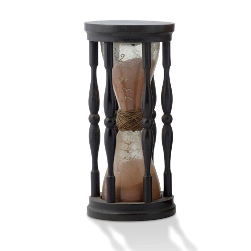
A ship's hour glass.
Maritime hourglass with blown glass bulbs, orange sand, junction ring covered with cord, the circular ebony frame with six turned baluster columns. The invention of the hourglass is attributed to an 8th-century monk in Chartres, France, with the marine sandglass appearing as early as the 14th century. In earlier examples, the bulbs were connected with a material such as putty or hardened wax, bound in leather, linen or string. From about 1720, the two bulbs were welded together over a brass bead...
$2.000
Maker : ANONYMOUS
Place : Germany
Date : ca. 1750
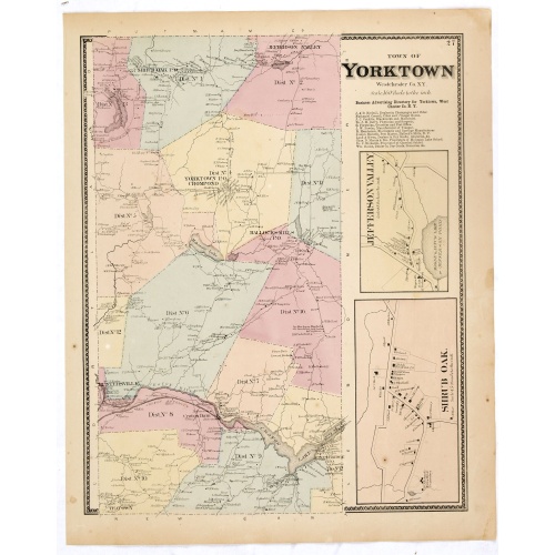
Town of Yorktown.
Fine lithographed map of the town of Yorktown. The map provides the names of specific homeowners, as well as information about the occupations and physical locations of the various tradesmen in each village from Beer's famous county atlas "Atlas of New York and vicinity," "a documentary record of nineteenth-century life and delightful specimens of American folk art." F. W. Beers, along with other members of his family, were among the leading county atlas publishers in the period immediately fol...
$90
Maker : DE BEERS, F.W.
Place : New York
Date : 1867
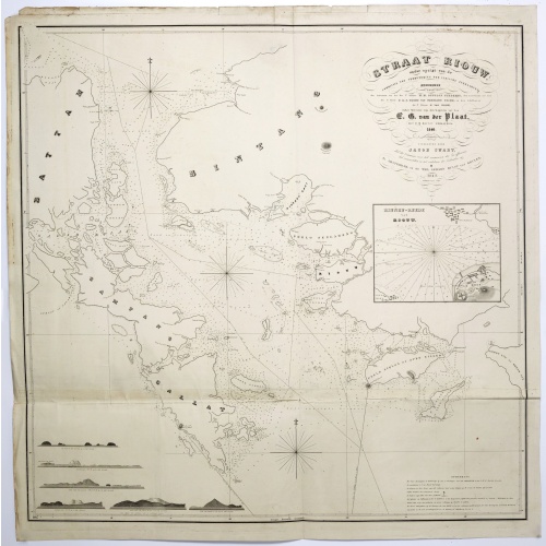
Straat Riouw onder opzicht van de commissie tot verbetering der Indische Zeekaarten..
Very large and rare so-called Blue Back chart centered on the strait passing between the Riau Islands. It contains an inset map with enlarged details of Riouw Harbor on Bintang Island.Coastal profiles are shown in the lower-left corner of the chart.The chart is prepared by W.H.Dittlof Tjassens, P.A.J.Bloijs van Treslong Prins and J.van Gogh during an expedition in 1840 by the ship Nehalennia under the command of Captain F.G.van der Plaat. The chart is engraved by D.Veelwaard Jr. And published in...
$1.250
Maker : HULST VAN KEULEN, Wed.G.
Place : Amsterdam
Date : 1843
Postage & Shipping
-
Item Location
Terms and conditions - Item Location
- Amsterdam, , Netherlands
- Ships To
- United States, United Kingdom, Albania, Argentina, Armenia, Australia, Azerbaijan, Bahamas, Belgium, Bermuda, Cambodia, Canada, Chile, China, Croatia, Cyprus, Czech Republic, Denmark, Estonia, Finland, France, Germany, Gibraltar, Greece, Greenland, Guatemala, Hong Kong, Iceland, India, Indonesia, Israel, Italy, Japan, Latvia, Lithuania, Luxembourg, Malta, Mexico, Monaco, Netherlands, Norway, Singapore, Spain, Sweden, Switzerland, Turkey
- Pick-ups
- No pick-ups
This item is owned and offered by the seller Paulus_Swaen_Old_Maps - All items are available for immediate sale, offered subject to prior sale.
Invoices are created by the seller by using our shopping cart or be prepared by the seller the day following the order and are emailed to you.
Items offeres by different sellers are invoiced separately.
Shipping fees are extra. The buyer is responsible for all applicable taxes, including any VAT, customs clearance, import duties, or equivalent costs arriving at the customer's home border. Payment is due on receipt of the invoice. The item(s) are shipped as soon as possible after receipt of your payment.
Before buying please read the complete Terms Conditions of Sale.
- Payment Methods
- Visa, Mastercard, Bank Transfer, American Express, iDEAL, PayPal, Google Pay
- Returns Accepted
- No
Post Message
Feel free to ask the seller a question. Please note that the seller could be located in an area with a different time zone. Our seller will do their best to respond within 24 hours.Post your message below.
Sign in to ask the seller a question.