
ID: 116
Open
Listing ID: #116 has been added to your wishlist.
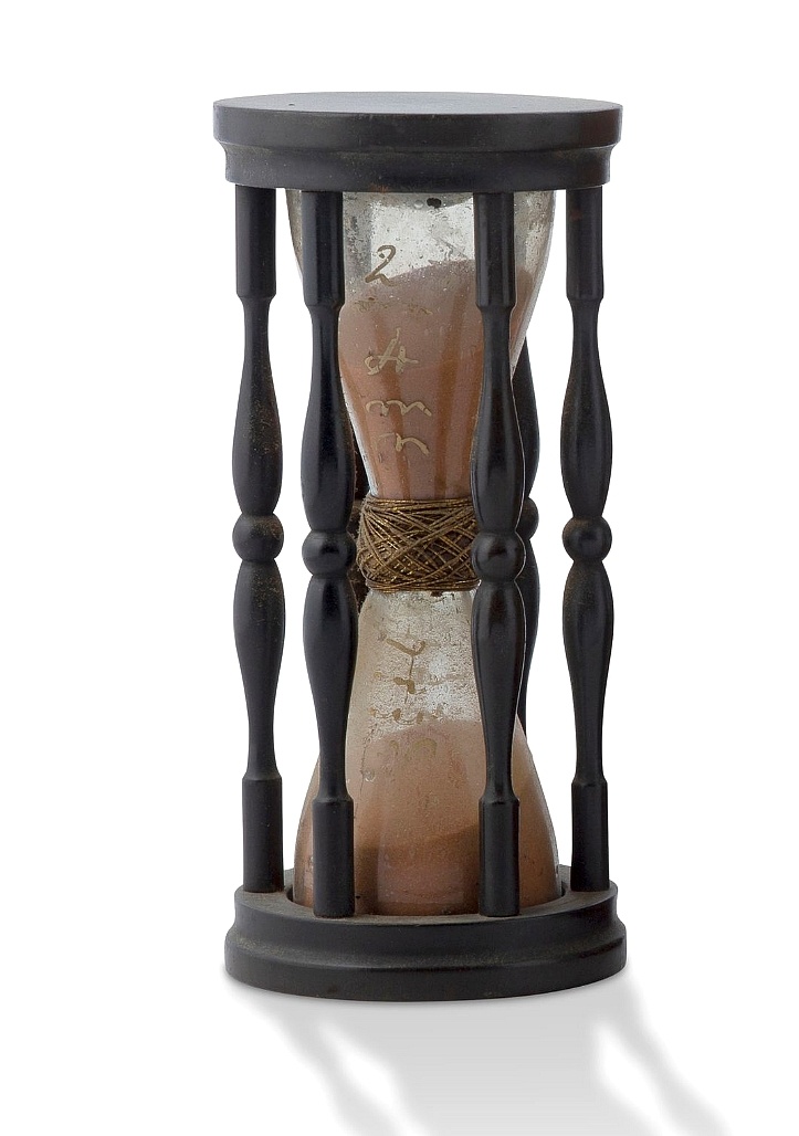
A ship's hour glass.
BuyNow for $2.000
- Maker :
- ANONYMOUS
- Place :
- Germany
- Date :
- ca. 1750
- Color :
- Uncoloured
- Height mm.:
- 138
- Width mm.:
- 64
- Condition :
- Two glass ampoules joined with modern wax silk thread and twine in oak framed with six carved oak columms
- Bibliography :
- -
- Seller's ref. :
- 48703
This item is offered by Paulus_Swaen_Old_Maps
See other Items from this seller- Postage
-
Standard Shipping
$0 to Netherlands
- Select Country
- Zip/Post Code
- Quantity
$2.000
Description
Maritime hourglass with blown glass bulbs, orange sand, junction ring covered with cord, the circular ebony frame with six turned baluster columns.
The invention of the hourglass is attributed to an 8th-century monk in Chartres, France, with the marine sandglass appearing as early as the 14th century. In earlier examples, the bulbs were connected with a material such as putty or hardened wax, bound in leather, linen or string. From about 1720, the two bulbs were welded together over a brass bead drilled with a hole, often still bound in leather.
From around 1760, the glass was blown in one piece (with the sand inserted in the cooled end before sealing it).
Ships would use the glasses to measure time at sea on a given navigational course. The invention of clocks and watches largely superseded the practical need for hourglasses.

Beschrijvinge vande de zee Cuften va Vlanderen en Picardien. . .
DUTCH TEXT EDITION. A detailed chart of the coast of Flanders and Normandy decorated by a large colorful baroque title cartouche, and the coat of arms of Flanders with a colorful scale cartouche decorated with a compass, a compass rose, several vessels and sea monsters. From an early Dutch text edition of this landmark contribution to the science of navigation. Waghenaer's own personal experiences as a pilot along European coasts were used to compile the Spiegel der Zeevaerdt, the first edition ...
$3.000
Maker : WAGHENAER, L. J.
Place : Leiden, Plantijn
Date : 1585

Pas-Kaat vaneen gedeelte van de Aethiopische Zee behelsende de Kusten Zanguebar, Ajan en Abex, en een gedeelte van de Arabische Kust. . .
A finely engraved and detailed chart of the most eastern tip of Africa, including Somalia, Djibouti, Yemen, Mauritius, and many other islands in the Indian Ocean.Very rare: only included in 6th volume (so-called secret atlas) of Van Keulen's. Latitude scale, compass rose and system of rhumb lines, soundings, anchorage's, etc. Many Dutch names and a wealth of cities and information appear in the chart. The trading posts of the different nations are marked with flags. Number 47. in lower left corn...
$4.500
Maker : VAN KEULEN, J.
Place : Amsterdam
Date : 1753

Rotterdam
A bird's-eye view of the town. With extensive shipping in the foreground. From "Topographia Germaniae Inferioris". Matthäus Merian, the leading German illustrator of the 17th century, was born in Basel in 1593. He learned the art of copperplate engraving in Zurich and subsequently worked and studied in Strasbourg, Nancy, Paris, and the Low Countries. In 1618 he went to Frankfurt, wherein 1618 he marries the eldest daughter of J.T. de Bry, publisher and engraver. After de Bry died in 1623, he ...
$1.750
Maker : MERIAN, C.
Place : Frankfurt
Date : 1659

A new mape of Ye XVII Provinces of Low Germanie.
Showing all 17 Provinces of the Netherlands before the split between Spain and the Protestant Provinces under the House of Orange.The map was first published. At the same time, the war of independence was still being fought against Philip II. With columns of figures on either side and surmounted by eight city prospects. A famous and most decorative item.A fourth state published by Thomas Basset and Richard Chiswell. The date has been removed and Speed's name has been added to the title cartouche...
$2.300
Maker : SPEED, J.
Place : London, 1676
Date : 1626
Postage & Shipping
-
Item Location
Terms and conditions - Item Location
- 75013, Ile-de-France, France
- Ships To
- United States, United Kingdom, Albania, Argentina, Armenia, Australia, Azerbaijan, Bahamas, Belgium, Bermuda, Cambodia, Canada, Chile, China, Croatia, Cyprus, Czech Republic, Denmark, Estonia, Finland, France, Germany, Gibraltar, Greece, Greenland, Guatemala, Hong Kong, Iceland, India, Indonesia, Israel, Italy, Japan, Latvia, Lithuania, Luxembourg, Malta, Mexico, Monaco, Netherlands, Norway, Singapore, Spain, Sweden, Switzerland, Turkey
- Pick-ups
- No pick-ups
This item is owned and offered by the seller Paulus_Swaen_Old_Maps - All items are available for immediate sale, offered subject to prior sale.
Invoices are created by the seller by using our shopping cart or be prepared by the seller the day following the order and are emailed to you.
Items offeres by different sellers are invoiced separately.
Shipping fees are extra. The buyer is responsible for all applicable taxes, including any VAT, customs clearance, import duties, or equivalent costs arriving at the customer's home border. Payment is due on receipt of the invoice. The item(s) are shipped as soon as possible after receipt of your payment.
Before buying please read the complete Terms Conditions of Sale.
- Payment Methods
- Visa, Mastercard, Bank Transfer, American Express, iDEAL, PayPal, Google Pay
- Returns Accepted
- No
Post Message
Feel free to ask the seller a question. Please note that the seller could be located in an area with a different time zone. Our seller will do their best to respond within 24 hours.Post your message below.
Sign in to ask the seller a question.
