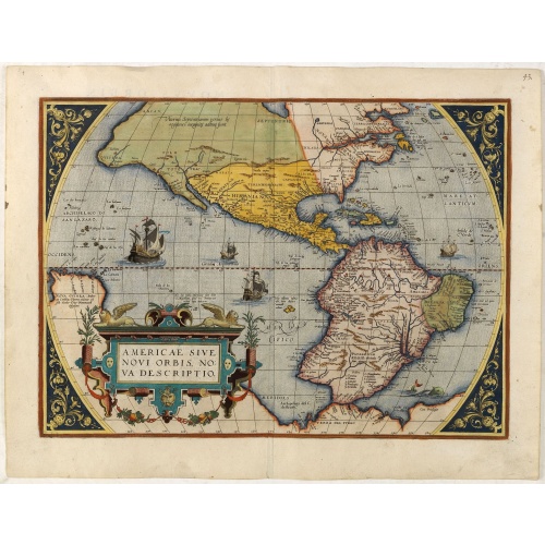
Americae Sive Novi Orbis, Nova Descriptio.
This is the second copperplate of Ortelius'.
$5.500
Maker : ORTELIUS, A.
Place : Antwerp
Date : 1579

Inventio Maris Magallanici.
Allegorical scene allegorical image celebrating the circumnavigation of the earth by Ferdinand Magellan. The image shows Magellan on board of his ship, surrounded by mythological figures including Apollo with sun and lyre, Zeus on his throne of clouds, Adam and Eve. A bird carrying an elephant and a depiction of the Tierra del Fuego.The image also includes cannon, banner with the double-headed Hapsburg eagle, anchor, broken mast, navigational instruments such as armillary sphere and dividers, se...
$750
Maker : DE BRY, Th.
Place : Frankfurt
Date : 1594
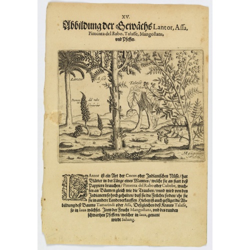
Plants Lantor, Assa, Pimenta, Mangostan and Pepper.
Lantor is a kind of coconut palm (or Indian nut) with fronds as long as a human body. These fronds are used as paper. Pimenta del Rabo (or cubebe) grows grape-like on trees and is held in such esteem by the Indians that they cook and preserve them, rather than sell them to other countries. Also shown is the Tamarind tree or Assa, the plant Talasse grows in Java, and the Mangostan fruit and the black pepper is called ‘Sahang’ in Java.Theodore de Bry, a German engraver and book dealer, began a...
€80
Maker : DE BRY, Th.
Place : Frankfurt
Date : 1598
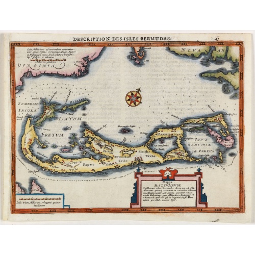
Description des Isles Bermudas.
Map of Bermuda from the rare Cloppenburg edition slightly larger format and more scarce edition of the Mercator/Hondius "Atlas Minor". Engraved by Pieter Van Den Keere.The Cloppenburg edition "Atlas Sive Cosmographicae Meditationes De Fabrica Mundi Et Fabricati Figura", was continued for a couple of years but seems to have been suppressed after 1636 ... (Koeman Atlantes Neerlandici).Based on the 1595 Abraham Ortelius map, but with added decoration.
€800
Maker : MERCATOR, G. / CLOPPENBURGH, J.E.
Place : Amsterdam
Date : 1630
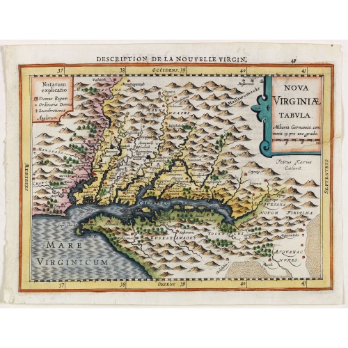
Virginiae item et Floridae . . .
Map of Virginia from the rare Cloppenburg edition slightly larger format and more scarce edition of the Mercator/Hondius "Atlas Minor". Engraved by Pieter Van Den Keere.The Cloppenburg edition "Atlas Sive Cosmographicae Meditationes De Fabrica Mundi Et Fabricati Figura", was continued for a couple of years but seems to have been suppressed after 1636 ... (Koeman Atlantes Neerlandici).Based on the 1595 Abraham Ortelius map, but with added decoration.
€750
Maker : MERCATOR, G. / CLOPPENBURGH, J.E.
Place : Amsterdam
Date : 1630
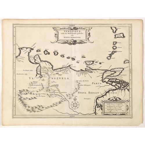
Venezuela, atque Occidentalis Pars Novæ Andalusiae.
Coastline of Venezuela with little interior development. Including Aruba, Bonaire, Curaçao, etc. Scarce map prepared by Hessel Gerritsz (1581-1632), former apprentice of Willem Blaeu, and Blaeu’s predecessor as chief cartographer of the Dutch East India Company. Gerritsz enjoys a very high reputation for his critical approach towards his sources.Most of Gerritsz’ work exists only in manuscript, and these maps published by de Laet, are among the only printed Gerritsz maps available to the co...
$600
Maker : LAET, DE J. / GERITSZ, H.
Place : Leiden, Elzevier
Date : 1630
![[A prisoner of the Indians of Tupinamba, covered in feathers . . .]](/uploads/cache/41101-500x500.jpg)
[A prisoner of the Indians of Tupinamba, covered in feathers . . .]
A graphic scene of fighting and extreme violence. One man is seen covered in feathers, before being sacrificed and killed before the Brazilian tribe of Tupinamba. In 1631 Johann Ludwig Gottfried, inherited the Theodor De Bry’s publishing firm, among the illustrated accounts of the expeditions of Magellan, Columbus, Vespucci, Cortes, Balboa, Raleigh, Drake, Smith, and many others.Gottfried issued together with Matthaeus Merian a one-volume condensation "Newe Welt Vnd Americanische Historien/ Jn...
€80
Maker : GOTTFRIED, J.L. / DE BRY.
Place : Frankfurt, M.Merian
Date : 1633
![[French seizure of Chiorera.]](/uploads/cache/39911-500x500.jpg)
[French seizure of Chiorera.]
Scarce print with a German text sheet showing the French torching and looting Chiorera. From de Bry's "Great American Voyages". Johann Theodor de Bry (1561-1623) was born in Liège in 1561, the eldest son of the engraver and publisher Theodor de Bry. It was from his father that Johann learned his craft, producing both engravings and etchings. In 1588, the Lutheran De Bry family settled in Frankfurt am Main, a safe haven for Lutherans at this time of religious discord. Together with his father an...
$80
Maker : GOTTFRIED, J.L. / DE BRY.
Place : Frankfurt, M.Merian
Date : 1633
![[Diego de Almagro is killed.]](/uploads/cache/40354-500x500.jpg)
[Diego de Almagro is killed.]
Almagro returned to Cuzco, disillusioned and embittered from his long and fruitless journey south into Chile, where he had been searching for further wealth. This led to a split in the control of Peru between the Pizarrists, who held the coastal regions, and the Almagrists who held the Cordillera. Further quarreling culminated in a battle just outside Cuzco in 1538, known as Las Salinas, which the Pizarrists eventually won. Almagro was subsequently garrotted and his captain, Orgóñez, beheaded....
$80
Maker : GOTTFRIED, J.L. / DE BRY.
Place : Frankfurt, M.Merian
Date : 1633
![[How the Inca nobility are buried] / [Bridge of Huaynacapaco]](/uploads/cache/41094-500x500.jpg)
[How the Inca nobility are buried] / [Bridge of Huaynacapaco]
Two engravings. [470] The funeral of an Inca king was a ceremony of great splendor. After digging a large pit, the Indians would decorate the corpse with gold and silver then bury it with many fine ornaments, along with good food and wine to help it on its way into the next world. Benzoni so described the burial of Huayna-Capac, whose grave he said was on the border of the province of Quito. When the Spanish first went to Peru, they discovered and pillaged many such graves.[469] Much of Ecuador ...
€80
Maker : GOTTFRIED, J.L. / DE BRY.
Place : Frankfurt, M.Merian
Date : 1633
![[The bloody battle at Chupas] / [Francesco Pizzaro is killed].](/uploads/cache/41093-500x500.jpg)
[The bloody battle at Chupas] / [Francesco Pizzaro is killed].
Two engravings. [492] Even before Pizarro’s death, a new royal governor, Vaca de Castro, was on his way to settle the turmoil in Peru. He refused to accept Almagro the younger, when he heard he had appointed himself the new governor and summoned his troops for battle. They were later joined by Alonso de Alvarado and by other Pizarrists. This culminated in a bloody battle at Chupas in 1542, near the city of Ayacucho. Many men on both sides died, before Almagro the younger, fled to Cuzco. He was...
€80
Maker : GOTTFRIED, J.L. / DE BRY.
Place : Frankfurt, M.Merian
Date : 1633
![[Collective suicide under Spanish rule.]](/uploads/cache/40480-500x500.jpg)
[Collective suicide under Spanish rule.]
The natives of Hispaniola, who saw no end to the fearful oppression of Spanish rule, preferred death. So many, devoid of all hope, went into the woods to kill their children and hang themselves. After taking certain natural poisons, the women followed their husbands to death by means of the noose. Others threw themselves down mountains, jumped into the sea or into rivers, while some died by self-imposed starvation or even stabbed themselves to death with razor sharp stone knives:In 1631 Johann L...
€80
Maker : GOTTFRIED, J.L. / DE BRY.
Place : Frankfurt, M.Merian
Date : 1633
![[Spilbergen's fleet visits the island of Santa Maria] / [The Dutch visit Isla Mocha].](/uploads/cache/41090-(1)-500x500.jpg)
[Spilbergen's fleet visits the island of Santa Maria] / [The Dutch visit Isla Mocha].
Two engravings. [514] On 29th May, 1615, Spilbergen’s fleet anchored further north, off an island called Santa María that was separated by a narrow stretch of water (A), from Punta Lavapié on the mainland. Four of the ships (I) anchored in the bay, while the fifth (H) anchored closer. The Dutch went ashore in small boats (F), where they saw Spanish soldiers on horseback (B), so they arranged themselves for battle (C). There were several confrontations (E), during which many Dutchmen died but...
$80
Maker : GOTTFRIED, J.L. / DE BRY.
Place : Frankfurt, M.Merian
Date : 1633
![[How natives of Paria cope with illness] / Vespucci reaches Lake Maracaibo]..](/uploads/cache/41095-(2)-500x500.jpg)
[How natives of Paria cope with illness] / Vespucci reaches Lake Maracaibo]..
Two engravings. [421b] When the natives of those parts, they were bathed in a cold stream, then chased round a blazing fire until they had dried out. Then they were put to bed and great care was taken to ensure their loins were dry. Vomiting was overcome by fasting for three or four days and paying careful attention to diet., which rarely included meat, except for human flesh, of which they were inordinately fond. In fact they would even fatten their enemy captives before eating them and seemed ...
$80
Maker : GOTTFRIED, J.L. / DE BRY.
Place : Frankfurt, M.Merian
Date : 1633
![[How the Inca nobility are buried] / [Bridge of Huaynacapaco]](/uploads/cache/41094-(1)-500x500.jpg)
[How the Inca nobility are buried] / [Bridge of Huaynacapaco]
Two engravings. [470] The funeral of an Inca king was a ceremony of great splendor. After digging a large pit, the Indians would decorate the corpse with gold and silver then bury it with many fine ornaments, along with good food and wine to help it on its way into the next world. Benzoni so described the burial of Huayna-Capac, whose grave he said was on the border of the province of Quito. When the Spanish first went to Peru, they discovered and pillaged many such graves.[469] Much of Ecuador ...
$80
Maker : GOTTFRIED, J.L. / DE BRY.
Place : Frankfurt, M.Merian
Date : 1633
![[Black slaves escape punishment].](/uploads/cache/39920-500x500.jpg)
[Black slaves escape punishment].
Scarce print with a German text sheet. Many Black slaves, weary of ill treatment, managed to escape Spanish captivity and freely wandered the island, breaking into prisons and recruiting other slaves. Soon they outnumbered the Spanish and sought revenge by killing some of them. After a meeting at the governor’s palace in Santo Domingo, many Spanish soldiers were sent out to quell the rebellion by catching the Blacks by night and hanging them from trees. The Blacks learnt from this to keep a lo...
$80
Maker : GOTTFRIED, J.L. / DE BRY.
Place : Frankfurt, M.Merian, 1633
Date : 1633
![[Captain Weert dines with the Chief].](/uploads/cache/39922-500x500.jpg)
[Captain Weert dines with the Chief].
Scarce print with a German text sheet. Captain Weert and the chief ate modestly on roast plantain, smoked fish and wine fermented from palm, bought by a local woman. However, when Weert ordered Spanish wine to be brought from his ship, the chief forgot his temperance and drank so much he had to be carried to rest. Weert had to stay the night but returned to his ship in the morning.On the way back he was confronted by an ugly, naked woman carrying ashes in a box. After circling him three times an...
$80
Maker : GOTTFRIED, J.L. / DE BRY.
Place : Frankfurt, M.Merian
Date : 1633
![[Cavendish reaches Morro Moreno.]](/uploads/cache/39910-500x500.jpg)
[Cavendish reaches Morro Moreno.]
Scarce print with a German text sheet showing Cavendish’s fleet anchor at a place called Morro Moreno, on the coast of Chile. The Indians came down from the high cliffs to greet the voyagers and brought with them firewood and fresh water as a sign of friendship. Later the English were taken to their homes, which were made from two sticks in the ground, with others laid across and covered with straw. The whole family, including children, lay underneath on animal skins. They were skilled fisherm...
$80
Maker : GOTTFRIED, J.L. / DE BRY.
Place : Frankfurt, M.Merian
Date : 1633
![[The strange sheep-like creatures that carried the silver .]](/uploads/cache/40481-500x500.jpg)
[The strange sheep-like creatures that carried the silver .]
When the Spanish discovered the silver mines of Potosí, they organised the transport of the rich ore westward by llama trains across the Altiplano and down to Arica on the coast, where it would be transported by ship to Panama. These strange creatures would sit down when angered or overburdened and, neither beatings nor kind words would make the animals get up again. If any of them ran away, they had to be shot to recover their valuable cargo.In 1631, Johann Ludwig Gottfried inherited Theodor D...
€80
Maker : GOTTFRIED, J.L. / DE BRY.
Place : Frankfurt, M.Merian, 1633
Date : 1633
![[Spanish take over Cusco] / [Atahualpa is garrotted].](/uploads/cache/41092-500x500.jpg)
[Spanish take over Cusco] / [Atahualpa is garrotted].
Two engravings. [486] After Atahualpa was killed, Pizarro set out with his troops to find the city of Cuzco, which he had heard was rich in gold. The journey from Cajamarca to Cuzco by road was nearly a thousand miles and took three months. Although there was considerable resistance to the Spanish during this long march, the final descent into the great city, in November 1533, was in fact, not as portrayed but a relatively peaceful affair. [485] While Atahualpa was still held captive rumors spre...
€80
Maker : GOTTFRIED, J.L. / DE BRY.
Place : Frankfurt, M.Merian
Date : 1633