ID: 329
Open
Listing ID: #329 has been added to your wishlist.
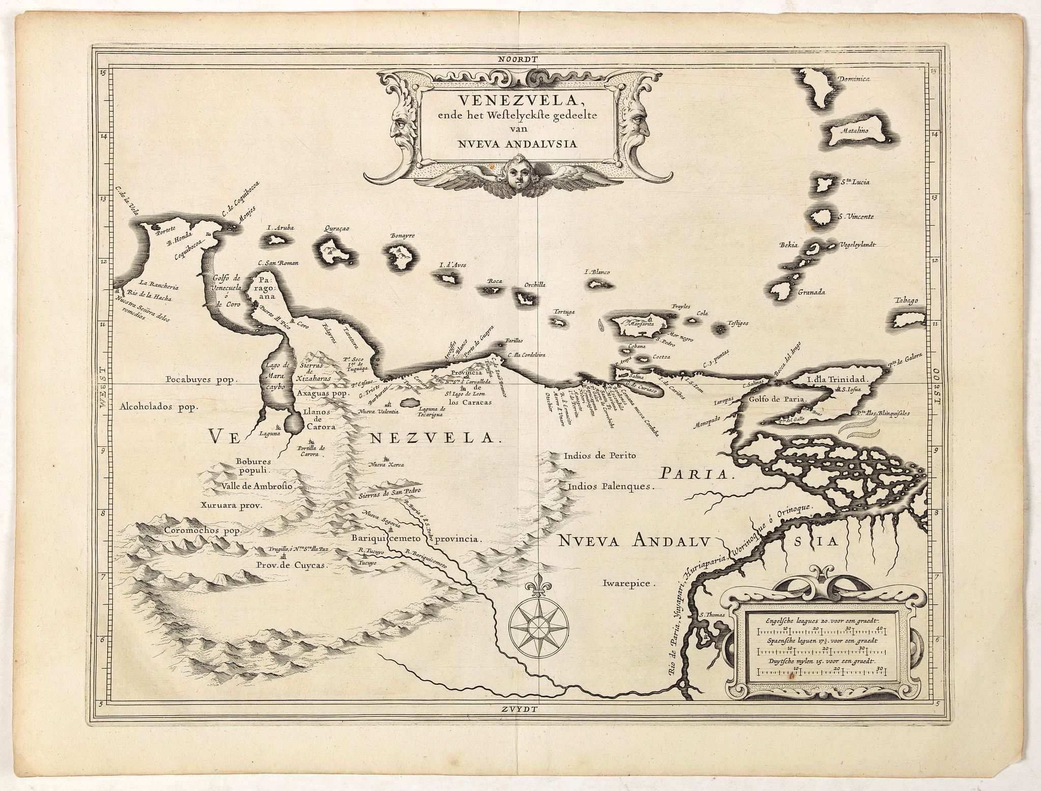
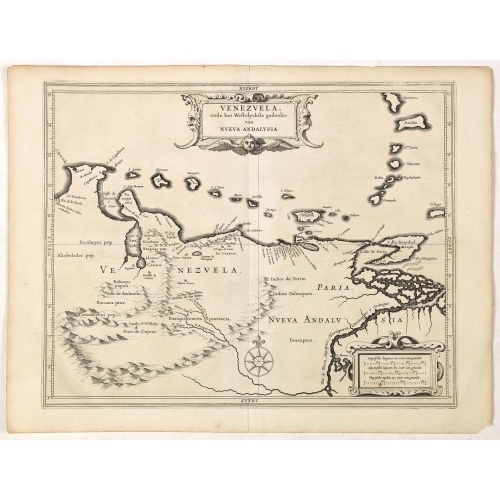
Venezuela, atque Occidentalis Pars Novæ Andalusiae.
BuyNow for $600
- Maker :
- LAET, DE J. / GERITSZ, H.
- Place :
- Leiden, Elzevier
- Date :
- 1630
- Color :
- Uncolored
- Height mm.:
- 280
- Width mm.:
- 356
- Condition :
- Very good and dark impression. Some very minor toning. Very fine to mint.
- Bibliography :
- -
- Seller's ref. :
- 43449
This item is offered by Paulus_Swaen_Old_Maps
See other Items from this seller- Postage
-
Europe
$34 to France
- Select Country
- Zip/Post Code
- Quantity
$600
Description
Coastline of Venezuela with little interior development. Including Aruba, Bonaire, Curaçao, etc. Scarce map prepared by Hessel Gerritsz (1581-1632), former apprentice of Willem Blaeu, and Blaeu’s predecessor as chief cartographer of the Dutch East India Company. Gerritsz enjoys a very high reputation for his critical approach towards his sources.Most of Gerritsz’ work exists only in manuscript, and these maps published by de Laet, are among the only printed Gerritsz maps available to the collector and institution today.
Published in first issue of Joannes De Laet's "Nieuwe Wereldt ofte Beschrijvinghe van West-Indien". First edition in Latin (first edition in Dutch, 1625, expanded and improved in 1630, also in Dutch, with four regional American maps and other material not in the 1625 edition). This work is “one of the most famous contemporary descriptions of the natural history of the New World” (Streeter Sale 37) and one of the early atlases to focus exclusively on America after Wytfliet’s atlas of 1597 and Herrera’s 1601 atlas.
"Arguably the finest description of the Americas published in the seventeenth century" (Burden).
Johannes De Laet was important in the founding of New Netherlands, and was a director of the Dutch West India Company, which sponsored its settlement.
He owned a large tract of land in upstate New York, near Albany, and therefore had access to surveys and information from Dutch colonists, thus enhancing his ability to produce fine maps such as this example at such an early date.
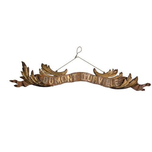
Transom of a ship in gilded carved wood bearing the inscription "DUMONT- DURVILLE"
Decorative transom sign in gilded carved wood bearing the inscription "DUMONT- DURVILLE" in a foliage environment. The transom usually kept the name of the ship and was often well-decorated.A transom is the flat, vertical surface at the back of a ship that connects the two sides of the hull. The sign holds the name of the great French explorer Jules Dumont d'Urville D’Urville who first visited New Zealand in 1824 as second-in-command to Louis Duperrey. On his second voyage of exploration and...
$7.500
Maker : ANONYMOUS
Place : France
Date : 1880
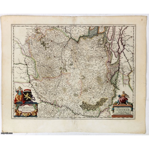
Brabantia Ducatus.
A very decorative map by Willem Blaeu with west is at the top. On the lower left a magnificent cartouche with a sitting female figure carrying a globe and compasses and the coat of arms of Brabant. The map encloses the area between the rivers Rhine, Meuse and Scheldt, with Namur (Namen) as the most southern town.
$400
Maker : BLAEU, W.
Place : Amsterdam, 1645
Date : 1645

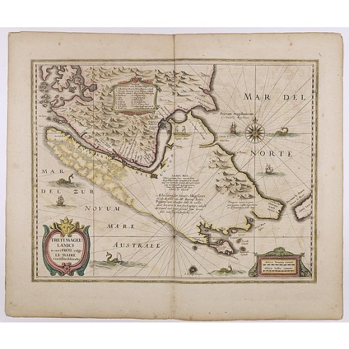
Pas kaart Van Rio Oronoque Golfo De Paria met d'Eylanden Trinidad, Tabago, Granada, Granadillos, en Bequia . . .
A highly detailed and rare sea chart of the mouth of the Orinoco River, Trinidad, Tabago, St.Vincent and neighboring islands. Oriented with north to the right by two compass roses.A large inset shows Tobago on a larger scale. Taken from De Nieuwe Groote Lichtende Zee-Fakkel, Part IV.Decorative scale cartouche features Neptune with his entourage and natives with trade goods. The chart is further adorned with a monkey atop the title cartouche and a sailing ship.
$900
Maker : VAN KEULEN, J.
Place : Amsterdam
Date : 1684

Pas-Kaat vaneen gedeelte van de Aethiopische Zee behelsende de Kusten Zanguebar, Ajan en Abex, en een gedeelte van de Arabische Kust. . .
A finely engraved and detailed chart of the most eastern tip of Africa, including Somalia, Djibouti, Yemen, Mauritius, and many other islands in the Indian Ocean.Very rare: only included in 6th volume (so-called secret atlas) of Van Keulen's. Latitude scale, compass rose and system of rhumb lines, soundings, anchorage's, etc. Many Dutch names and a wealth of cities and information appear in the chart. The trading posts of the different nations are marked with flags. Number 47. in lower left corn...
$4.500
Maker : VAN KEULEN, J.
Place : Amsterdam
Date : 1753
Postage & Shipping
-
Item Location
Terms and conditions - Item Location
- Amsterdam, , Netherlands
- Ships To
- United States, United Kingdom, Albania, Argentina, Armenia, Australia, Azerbaijan, Bahamas, Belgium, Bermuda, Cambodia, Canada, Chile, China, Croatia, Cyprus, Czech Republic, Denmark, Estonia, Finland, France, Germany, Gibraltar, Greece, Greenland, Guatemala, Hong Kong, Iceland, India, Indonesia, Israel, Italy, Japan, Latvia, Lithuania, Luxembourg, Malta, Mexico, Monaco, Netherlands, Norway, Singapore, Spain, Sweden, Switzerland, Turkey
- Pick-ups
- No pick-ups
This item is owned and offered by the seller Paulus_Swaen_Old_Maps - All items are available for immediate sale, offered subject to prior sale.
Invoices are created by the seller by using our shopping cart or be prepared by the seller the day following the order and are emailed to you.
Items offeres by different sellers are invoiced separately.
Shipping fees are extra. The buyer is responsible for all applicable taxes, including any VAT, customs clearance, import duties, or equivalent costs arriving at the customer's home border. Payment is due on receipt of the invoice. The item(s) are shipped as soon as possible after receipt of your payment.
Before buying please read the complete Terms Conditions of Sale.
- Payment Methods
- Visa, Mastercard, Bank Transfer, American Express, iDEAL, PayPal, Google Pay
- Returns Accepted
- No
Post Message
Feel free to ask the seller a question. Please note that the seller could be located in an area with a different time zone. Our seller will do their best to respond within 24 hours.Post your message below.
Sign in to ask the seller a question.