
ID: 156
Open
![[Columbus is standing in the bow of his ship]](/uploads/48524.jpg)
[Columbus is standing in the bow of his ship]
BuyNow for $400
- Maker :
- DE BRY, Th.
- Place :
- Frankfurt
- Date :
- 1594
- Color :
- Colored
- Height mm.:
- 145
- Width mm.:
- 195
- Condition :
- Copper engraving with letter press in Latin on recto and verso. Paper very slightly age toned, as usual. Size of the sheet : 34x24cm.
- Bibliography :
- Tooley (TMC-2) pp. 22-24.
- Seller's ref. :
- 48524
This item is offered by Paulus_Swaen_Old_Maps
See other Items from this seller- Postage
-
Europe
$36 to Netherlands
- Select Country
- Zip/Post Code
- Quantity
$400
Description
Columbus is standing in the bow of his ship, which is near the shore. He is clad in a long mantle and undercoat, while his armor lies at his feet, and his standard is floating from the foremast.Behind him is Minerva, carrying a spear and a shield with the head of Medusa in the center, presenting a laurel branch to Columbus.
Behind the goddess is Mars in full armor, standing on the back of a turtle for a chariot, and drawn by three lions. Near him, are two Sirens, whilst at the head of the vessel, are a Mermaid and a Triton acting as pilots.
In the far distance, is a flock of Harpies, typifying the sinister influences with which the Genoese had to contend. In the East is the rising sun and the territory which he had just discovered.
The image is based upon a 1592 engraving by Jan van der Straet, also known as Joannes [or Johannes] Stradanus, who created a series of four prints under the title America refection, celebrating the discovery of the new world.
The image was also re-issued in 1592 to commemorate the 100th Anniversary of Columbus' discovery of the New World.
Finally re-issued by de Bry in 'America', 4th Part, 1594, where the figures are now shown in reverse.
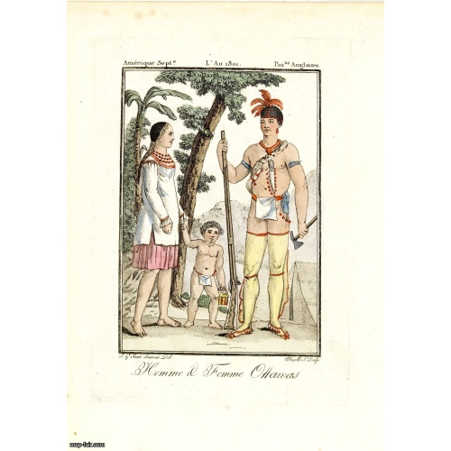
Homme & Femme Ottawas.
Hand-colored mezzotint of Native Americans engraved by Félix Mixelle and Lachaussée Jeune after Jacques Grasset de Saint-Sauveur.As an etcher, drawer and writer, Grasset de Saint-Sauveur was a prolific polygraph in keeping with the encyclopedic spirit of the eighteenth century: he wrote exotic novels as well as documentary works on various subjects. Called by one of his biographers a drawer without genius but a good example of the taste of his time, Grasset de Saint-Sauveur was literally bewit...
$75
Maker : GRASSET DE SAINT SAUVEUR,J.
Place : Paris,
Date : 1806
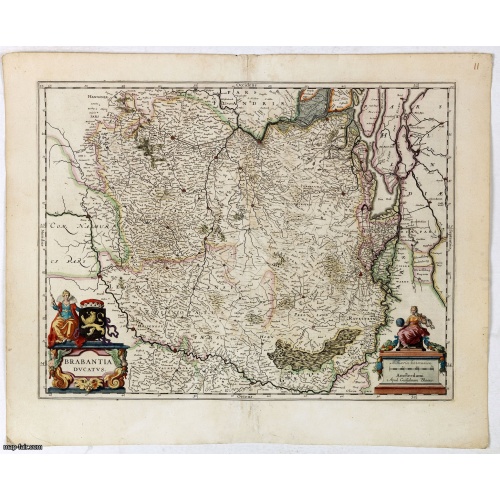
Brabantia Ducatus.
A very decorative map by Willem Blaeu with west is at the top. On the lower left a magnificent cartouche with a sitting female figure carrying a globe and compasses and the coat of arms of Brabant. The map encloses the area between the rivers Rhine, Meuse and Scheldt, with Namur (Namen) as the most southern town.
$400
Maker : BLAEU, W.
Place : Amsterdam, 1645
Date : 1645
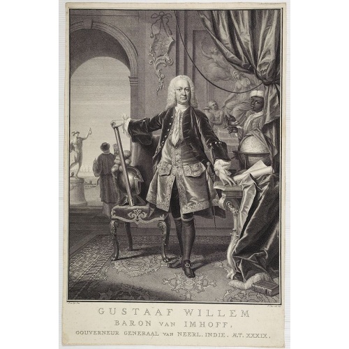
Gustaaf Willem Baron van Imhoff.
Decorative portrait of Gustaaf Willem Baron van Imhoff, who was Governor for the V.O.C. (Dutch East Indian Company) in Indonesia.
$750
Maker : TANJÉ, P.
Place : Amsterdam
Date : 1745
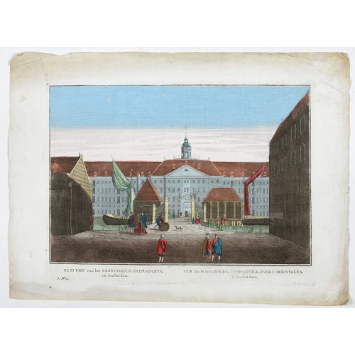
Vue du Magazin de la Compagnie des Indes Orientales. . .
So-called optical print of the formerly the V.O.C. warehouse and arsenal for the Admiralty of Amsterdam, now-a-days the Scheepvaartmuseum (Maritime Museum).In the eighteenth and nineteenth centuries there were many popular speciality establishments in Paris, Augsburg and London which produced optical viewing devices and special engravings to be viewed through them. In the 18th century the optical print or vue optique came into existence, whose exaggerated converging lines were intended to produc...
$550
Maker : ANONYMOUS
Place : France
Date : 1780
Postage & Shipping
-
Item Location
Terms and conditions - Item Location
- 75013, Ile-de-France, France
- Ships To
- United States, United Kingdom, Albania, Argentina, Armenia, Australia, Azerbaijan, Bahamas, Belgium, Bermuda, Cambodia, Canada, Chile, China, Croatia, Cyprus, Czech Republic, Denmark, Estonia, Finland, France, Germany, Gibraltar, Greece, Greenland, Guatemala, Hong Kong, Iceland, India, Indonesia, Israel, Italy, Japan, Latvia, Lithuania, Luxembourg, Malta, Mexico, Monaco, Netherlands, Norway, Singapore, Spain, Sweden, Switzerland, Turkey
- Pick-ups
- No pick-ups
This item is owned and offered by the seller Paulus_Swaen_Old_Maps - All items are available for immediate sale, offered subject to prior sale.
Invoices are created by the seller by using our shopping cart or be prepared by the seller the day following the order and are emailed to you.
Items offeres by different sellers are invoiced separately.
Shipping fees are extra. The buyer is responsible for all applicable taxes, including any VAT, customs clearance, import duties, or equivalent costs arriving at the customer's home border. Payment is due on receipt of the invoice. The item(s) are shipped as soon as possible after receipt of your payment.
Before buying please read the complete Terms Conditions of Sale.
- Payment Methods
- Visa, Mastercard, Bank Transfer, American Express, iDEAL, PayPal, Google Pay
- Returns Accepted
- No
Post Message
Feel free to ask the seller a question. Please note that the seller could be located in an area with a different time zone. Our seller will do their best to respond within 24 hours.Post your message below.
Sign in to ask the seller a question.
![[Columbus is standing in the bow of his ship]](/uploads/cache/48524-500x500.jpg)