
ID: 337
Open
Listing ID: #337 has been added to your wishlist.
Listing ID: #243 has been added to your wishlist.
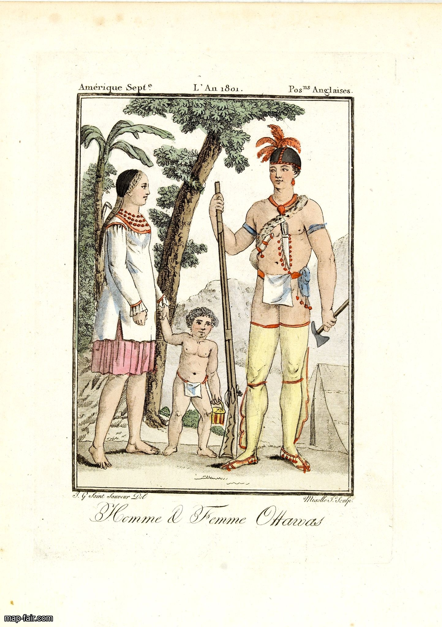
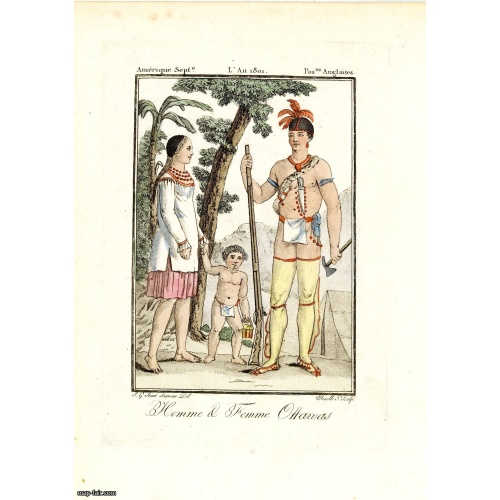
Homme & Femme Ottawas.
BuyNow for $75
- Maker :
- GRASSET DE SAINT SAUVEUR,J.
- Place :
- Paris,
- Date :
- 1806
- Color :
- In original colors.
- Height mm.:
- 130
- Width mm.:
- 85
- Condition :
- Some very light outer marginal age toning. In very good condition.
- Bibliography :
- -
- Seller's ref. :
- 33525
This item is offered by Paulus_Swaen_Old_Maps
See other Items from this seller- Postage
-
Europe
$34 to France
- Select Country
- Zip/Post Code
- Quantity
$75
Description
Hand-colored mezzotint of Native Americans engraved by Félix Mixelle and Lachaussée Jeune after Jacques Grasset de Saint-Sauveur.As an etcher, drawer and writer, Grasset de Saint-Sauveur was a prolific polygraph in keeping with the encyclopedic spirit of the eighteenth century: he wrote exotic novels as well as documentary works on various subjects.
Called by one of his biographers a drawer without genius but a good example of the taste of his time, Grasset de Saint-Sauveur was literally bewitched by costumes.
Born in Montreal in April 1757 - at the beginning of the Seven Years' War - Jacques Grasset de Saint-Sauveur went to live in France after the conquest of New France by the British. He studied at Sainte-Barbe College in Paris and then embarked on a diplomatic career. After serving as French vice-consul in Hungary for several years, he was promoted to the consul in Cairo.
He died in Paris in May 1810.
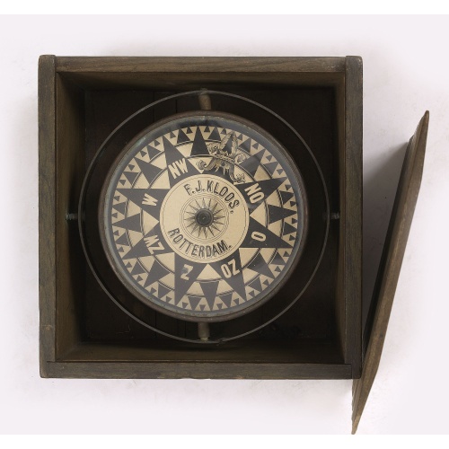
Compass.
A very nicely crafted sloop compass in original box. The compass is gimbaled and is executed in beautiful red copper. Made and signed by F.J. Kloos & Son of Rotterdam in the 1850-1875 period. The compass works fine. Height of the box: 13.5 cm (5.5 inches)
$2.250
Maker : KLOOS, F.J.
Place : Rotterdam
Date : 1850-1875
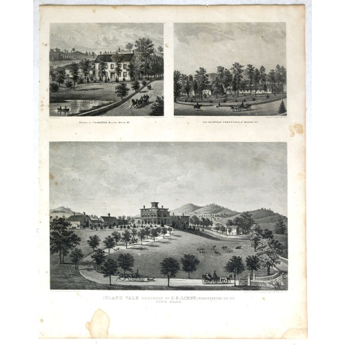
Property of F.A.Halstead Bedford Station, The Halstead Homestead at Bedford and Inland Vale residence of J.S.Libby, Westchester Co. NY North Salem.
Three heliographic prints on one sheet : "Property of F.A.Halstead Bedford Station", "The Halstead Homestead at Bedford" and "Inland Vale residence of J.S.Libby, Westchester Co. NY North Salem" after design by R.K.Sneden.From Beer's famous county atlas "Atlas of New York and vicinity, a documentary record of nineteenth century life and delightful specimens of American folk art". F. W. Beers, along with other members of his family, were among the leading county atlas publishers in period immediat...
$90
Maker : DE BEERS, F.W.
Place : New York
Date : 1867
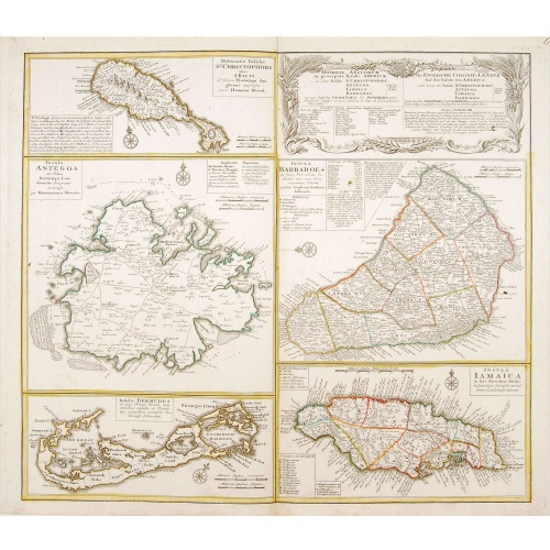
Dominia Anglorum in praecipuis Insulis Americae ut sunt Insula S. Christopheri, Antegoa, Iamaica, Barbados nec non Insula Bermudes vel Sommers . . .
Four maps of the islands of West Indies (St. Christoph "Delineatio Insulae St, Christophori alias I. Kitts", Antigua "Insula Antegoa", Barbados "Insula Barbadoes" and Iamaica "Insula Iamaica") and a map of Bermudas ("Insulae Bermudes") showing British possessions in the Caribbean. At the upper right of the sheet text in German relating to the areas depicted.A second edition with Bermudes. The first edition uses the name Bermudos.
$500
Maker : HOMANN HEIRS.
Place : Nuremberg
Date : 1740

Universe Europae Maritime Eiusque Navigationis Descriptio. Generale Pascaerte van Europa . . .
This general chart of north-western Europe and the surrounding coastal waters is from the rare pilot-guide De Spiegel der Zeevaerdt , printed by Christopher Plantin in Leyden.FIRST PLATE AND FIRST STATE, which appeared in the first 3 editions, before Latin names of some seas and inscriptions in the scale bars were added. (editions 4-12). EXTREMELY RARE.The map's title is given in both Latin and Dutch, with the latter attributing it to Waghenaer and nothing a privilege of ten years. The date 1583...
$25.000
Maker : WAGHENAER, L.J.
Place : Leyden
Date : 1584
Postage & Shipping
-
Item Location
Terms and conditions - Item Location
- Amsterdam, , Netherlands
- Ships To
- United States, United Kingdom, Albania, Argentina, Armenia, Australia, Azerbaijan, Bahamas, Belgium, Bermuda, Cambodia, Canada, Chile, China, Croatia, Cyprus, Czech Republic, Denmark, Estonia, Finland, France, Germany, Gibraltar, Greece, Greenland, Guatemala, Hong Kong, Iceland, India, Indonesia, Israel, Italy, Japan, Latvia, Lithuania, Luxembourg, Malta, Mexico, Monaco, Netherlands, Norway, Singapore, Spain, Sweden, Switzerland, Turkey
- Pick-ups
- No pick-ups
This item is owned and offered by the seller Paulus_Swaen_Old_Maps - All items are available for immediate sale, offered subject to prior sale.
Invoices are created by the seller by using our shopping cart or be prepared by the seller the day following the order and are emailed to you.
Items offeres by different sellers are invoiced separately.
Shipping fees are extra. The buyer is responsible for all applicable taxes, including any VAT, customs clearance, import duties, or equivalent costs arriving at the customer's home border. Payment is due on receipt of the invoice. The item(s) are shipped as soon as possible after receipt of your payment.
Before buying please read the complete Terms Conditions of Sale.
- Payment Methods
- Visa, Mastercard, Bank Transfer, iDEAL, PayPal
- Returns Accepted
- No
Post Message
Feel free to ask the seller a question. Please note that the seller could be located in an area with a different time zone. Our seller will do their best to respond within 24 hours.Post your message below.
Sign in to ask the seller a question.
![[Murder of Dominican monks in Cumana or Cubagua Island].](/uploads/cache/40177-500x500.jpg)
-500x500.jpg)