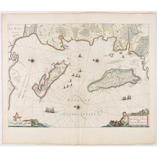
ID: 75
Open
Listing ID: #75 has been added to your wishlist.
.jpg)
Kaart van de Gaspar Straaten volgens opnemingen van J.Stolze, D.Ross, enz.
BuyNow for $900
- Maker :
- HULST VAN KEULEN, Wed.G.
- Place :
- Amsterdam
- Date :
- 1843
- Color :
- Uncoloured
- Height mm.:
- 610
- Width mm.:
- 908
- Condition :
- Good and dark impression. Slight age toning of paper. A symmetrical brown spot close to lower centerfold, 3 cm into the printed area. Else very good condition.
- Bibliography :
- -
- Seller's ref. :
- 23243-(1)
This item is offered by Paulus_Swaen_Old_Maps
See other Items from this seller- Postage
-
Europe
$34 to Netherlands
- Select Country
- Zip/Post Code
- Quantity
$900
Description
Very large and rare chart centered on the strait between Bangka's southeastern seacoast and Belitung's western shores.Short front views of the coastal relief are shown in the lower-left corner of the map.
The chart is prepared by H.L.Osthoff in 1840 and published in 1844 by Jacob Swart.
When Gerard Hulst van Keulen died in 1801, his widow ran the firm until her death in 1810, at which time Johannes Hulst van Keulen became the last van Keulen to run the firm.
In 1823, Jacob Swart entered the service of the van Keulen firm, and in 1844, with the death of Johannes Hulst van Keulen, head of the van Keulen Chartmakers was passed to Jacob Swart. When Jacob died in 1866, he was succeeded by his son, Jacob Swart, Jr. Finally, the possessions of the firm were sold at auction in 1885.
![[Captain Weert dines with the Chief].](/uploads/cache/39922-500x500.jpg)
[Captain Weert dines with the Chief].
Scarce print with a German text sheet. Captain Weert and the chief ate modestly on roast plantain, smoked fish and wine fermented from palm, bought by a local woman. However, when Weert ordered Spanish wine to be brought from his ship, the chief forgot his temperance and drank so much he had to be carried to rest. Weert had to stay the night but returned to his ship in the morning.On the way back he was confronted by an ugly, naked woman carrying ashes in a box. After circling him three times an...
$80
Maker : GOTTFRIED, J.L. / DE BRY.
Place : Frankfurt, M.Merian
Date : 1633
-500x500.jpg)
Town of Verplanck / Crugers / Croton Landing.
Fine lithographed map of the town of Verplanck / Crugers / Croton Landing. The map provides the names of specific homeowners, as well as information about the occupations and physical locations of the various tradesmen in each village from Beer's famous county atlas "Atlas of New York and vicinity," "a documentary record of nineteenth-century life and delightful specimens of American folk art." F. W. Beers, along with other members of his family, were among the leading county atlas publishers in...
$90
Maker : DE BEERS, F.W.
Place : New York
Date : 1867
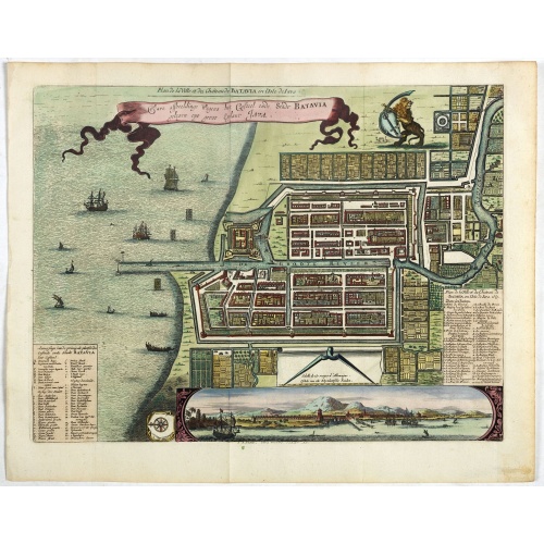
Ware affbeeldinge wegens het casteel ende stadt Batavia. . .
A reduced version of Clement de Jonghe (1650) plan of Jakarta from 1650. The town plan has a vignette at the bottom showing Jakarta from the sea with the volcanoes Mount Gede, Mount Pangrnago and Mount Salak in the background. Engraved for Arnoldus Montanus "Gedenkwaerdige gesantschappen der Oost-Indische maatschappy in ’t Vereenigde Nederland. . ." (1669) but reissued by Pieter van der AA.Batavia, present-day Jakarta, the Dutch center of trading activities in the East Indies. European and nat...
$800
Maker : VANDER AA, P.
Place : Leiden
Date : 1719

Mappe-Monde pour connoitre les progres & les conquestes..
Unusual double hemisphere map with California as an Island. Dutch text describes the expeditions and colonial possessions of the Dutch East India Company. The map originated in about 1670. Chatelain acquired the plate; he added decorative elements, including sailing ships, the Dutch crest, and a figure representing Europa seated inside a native fort.Zacharie Chatelain (d.1723) was the father of Henri Abraham (1684-1743) and Zacharie Junior (1690-1754).They worked as a partnership publishing the ...
$800
Maker : CHATELAIN, H.
Place : Amsterdam
Date : 1729
Postage & Shipping
-
Item Location
Terms and conditions - Item Location
- Amsterdam, , Netherlands
- Ships To
- United States, United Kingdom, Albania, Argentina, Armenia, Australia, Azerbaijan, Bahamas, Belgium, Bermuda, Cambodia, Canada, Chile, China, Croatia, Cyprus, Czech Republic, Denmark, Estonia, Finland, France, Germany, Gibraltar, Greece, Greenland, Guatemala, Hong Kong, Iceland, India, Indonesia, Israel, Italy, Japan, Latvia, Lithuania, Luxembourg, Malta, Mexico, Monaco, Netherlands, Norway, Singapore, Spain, Sweden, Switzerland, Turkey
- Pick-ups
- No pick-ups
This item is owned and offered by the seller Paulus_Swaen_Old_Maps - All items are available for immediate sale, offered subject to prior sale.
Invoices are created by the seller by using our shopping cart or be prepared by the seller the day following the order and are emailed to you.
Items offeres by different sellers are invoiced separately.
Shipping fees are extra. The buyer is responsible for all applicable taxes, including any VAT, customs clearance, import duties, or equivalent costs arriving at the customer's home border. Payment is due on receipt of the invoice. The item(s) are shipped as soon as possible after receipt of your payment.
Before buying please read the complete Terms Conditions of Sale.
- Payment Methods
- Visa, Mastercard, Bank Transfer, American Express, iDEAL, Google Pay
- Returns Accepted
- No
Post Message
Feel free to ask the seller a question. Please note that the seller could be located in an area with a different time zone. Our seller will do their best to respond within 24 hours.Post your message below.
Sign in to ask the seller a question.
-500x500.jpg)