ID: 341
Open
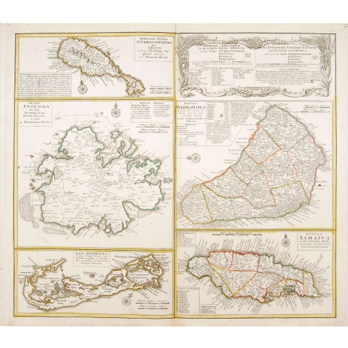
Dominia Anglorum in praecipuis Insulis Americae ut sunt Insula S. Christopheri, Antegoa, Iamaica, Barbados nec non Insula Bermudes vel Sommers . . .
BuyNow for $500
- Maker :
- HOMANN HEIRS.
- Place :
- Nuremberg
- Date :
- 1740
- Color :
- Colored.
- Height mm.:
- 490
- Width mm.:
- 558
- Condition :
- Very minor marginal discoloration.
- Bibliography :
- -
- Seller's ref. :
- 04452
This item is offered by Paulus_Swaen_Old_Maps
See other Items from this seller- Postage
-
Europe
$34 to France
- Select Country
- Zip/Post Code
- Quantity
$500
Description
Four maps of the islands of West Indies (St. Christoph "Delineatio Insulae St, Christophori alias I. Kitts", Antigua "Insula Antegoa", Barbados "Insula Barbadoes" and Iamaica "Insula Iamaica") and a map of Bermudas ("Insulae Bermudes") showing British possessions in the Caribbean.
At the upper right of the sheet text in German relating to the areas depicted.
A second edition with Bermudes. The first edition uses the name Bermudos.

Gustaaf Willem Baron van Imhoff.
Decorative portrait of Gustaaf Willem Baron van Imhoff, who was Governor for the V.O.C. (Dutch East Indian Company) in Indonesia.
$750
Maker : TANJÉ, P.
Place : Amsterdam
Date : 1745
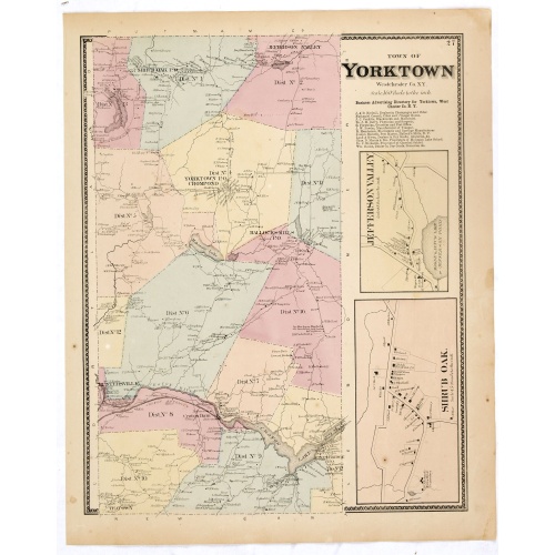
Town of Yorktown.
Fine lithographed map of the town of Yorktown. The map provides the names of specific homeowners, as well as information about the occupations and physical locations of the various tradesmen in each village from Beer's famous county atlas "Atlas of New York and vicinity," "a documentary record of nineteenth-century life and delightful specimens of American folk art." F. W. Beers, along with other members of his family, were among the leading county atlas publishers in the period immediately fol...
$90
Maker : DE BEERS, F.W.
Place : New York
Date : 1867
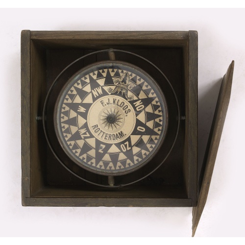
Compass.
A very nicely crafted sloop compass in original box. The compass is gimbaled and is executed in beautiful red copper. Made and signed by F.J. Kloos & Son of Rotterdam in the 1850-1875 period. The compass works fine. Height of the box: 13.5 cm (5.5 inches)
$2.250
Maker : KLOOS, F.J.
Place : Rotterdam
Date : 1850-1875

Very fine brass astronomical equinoctial ring with two brass circles.
Very fine brass astronomical equinoctial ring with two brass circles with engraved foliage decoration, signed "Jean-Baptiste-Nicolas Delure A Paris", on the hanger ring. The meridian ring is engraved with a latitude scale 90-0-90 degrees, reverse with a scale for determining solar altitude and zennith distance, an equinoctial ring with obverse engraved with hour scale in Roman numerals, the central bridge with pin-hole sliding over calendar and zodiac scales, 100 mm diam.Jean-Baptiste-Nicolas De...
$8.000
Maker : JEAN-BAPTISTE NICOLAS DELURE À PARIS
Place : Paris
Date : ca. 1690
Postage & Shipping
-
Item Location
Terms and conditions - Item Location
- Amsterdam, , Netherlands
- Ships To
- United States, United Kingdom, Albania, Argentina, Armenia, Australia, Azerbaijan, Bahamas, Belgium, Bermuda, Cambodia, Canada, Chile, China, Croatia, Cyprus, Czech Republic, Denmark, Estonia, Finland, France, Germany, Gibraltar, Greece, Greenland, Guatemala, Hong Kong, Iceland, India, Indonesia, Israel, Italy, Japan, Latvia, Lithuania, Luxembourg, Malta, Mexico, Monaco, Netherlands, Norway, Singapore, Spain, Sweden, Switzerland, Turkey
- Pick-ups
- No pick-ups
This item is owned and offered by the seller Paulus_Swaen_Old_Maps - All items are available for immediate sale, offered subject to prior sale.
Invoices are created by the seller by using our shopping cart or be prepared by the seller the day following the order and are emailed to you.
Items offeres by different sellers are invoiced separately.
Shipping fees are extra. The buyer is responsible for all applicable taxes, including any VAT, customs clearance, import duties, or equivalent costs arriving at the customer's home border. Payment is due on receipt of the invoice. The item(s) are shipped as soon as possible after receipt of your payment.
Before buying please read the complete Terms Conditions of Sale.
- Payment Methods
- Visa, Mastercard, Bank Transfer, iDEAL, PayPal
- Returns Accepted
- No
Post Message
Feel free to ask the seller a question. Please note that the seller could be located in an area with a different time zone. Our seller will do their best to respond within 24 hours.Post your message below.
Sign in to ask the seller a question.