ID: 341
Open
Listing ID: #341 has been added to your wishlist.
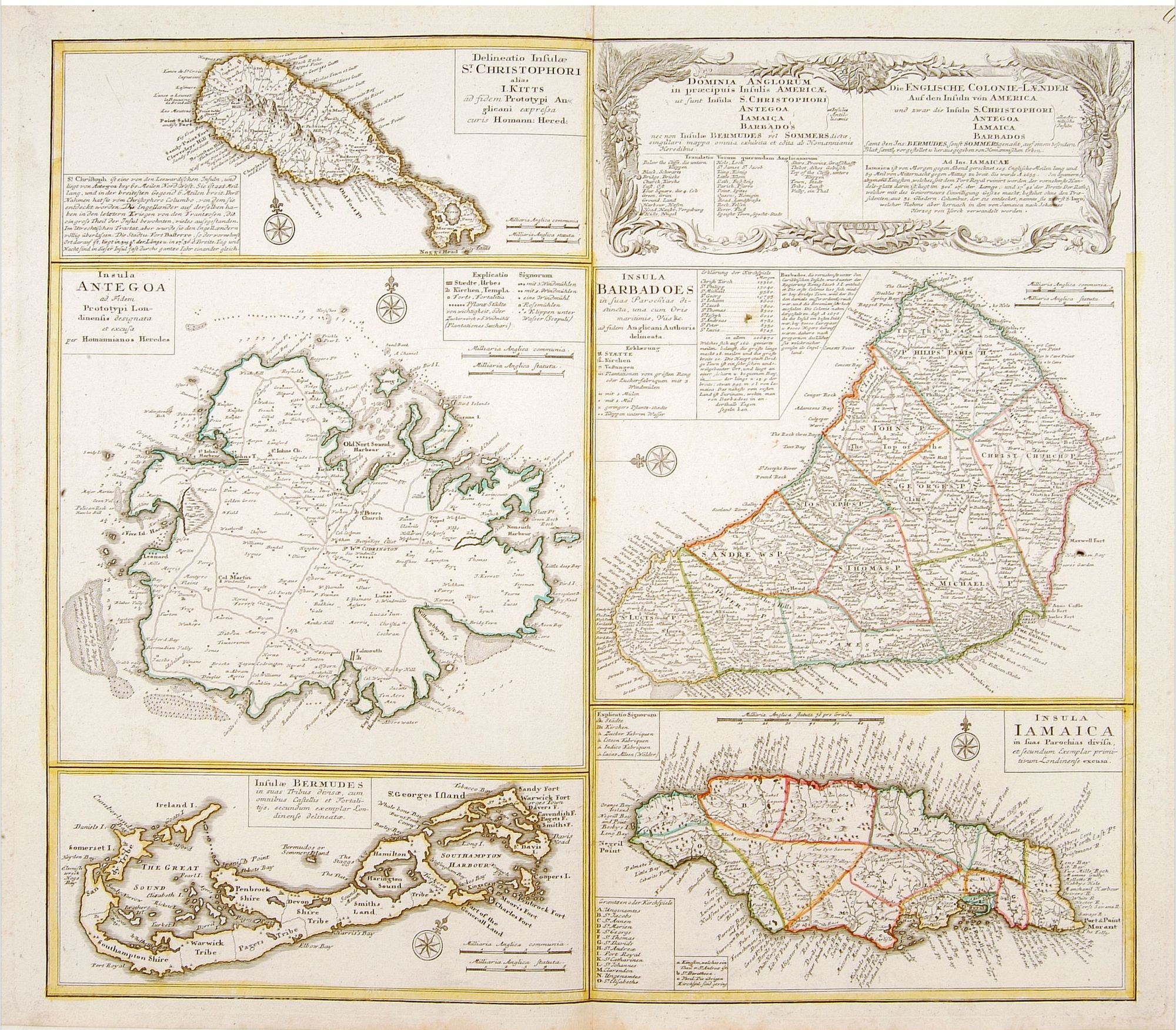
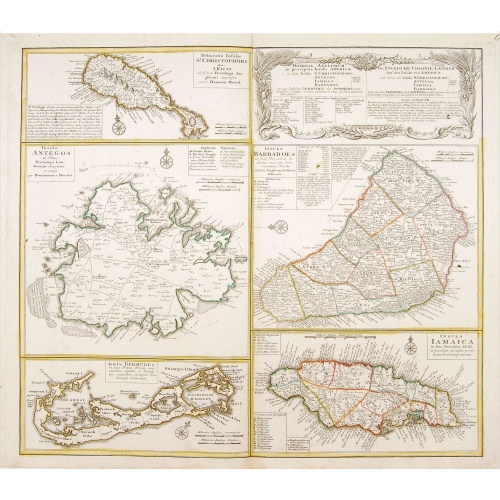
Dominia Anglorum in praecipuis Insulis Americae ut sunt Insula S. Christopheri, Antegoa, Iamaica, Barbados nec non Insula Bermudes vel Sommers . . .
BuyNow for $500
- Maker :
- HOMANN HEIRS.
- Place :
- Nuremberg
- Date :
- 1740
- Color :
- Colored.
- Height mm.:
- 490
- Width mm.:
- 558
- Condition :
- Very minor marginal discoloration.
- Bibliography :
- -
- Seller's ref. :
- 04452
This item is offered by Paulus_Swaen_Old_Maps
See other Items from this seller- Postage
-
Europe
$34 to France
- Select Country
- Zip/Post Code
- Quantity
$500
Description
Four maps of the islands of West Indies (St. Christoph "Delineatio Insulae St, Christophori alias I. Kitts", Antigua "Insula Antegoa", Barbados "Insula Barbadoes" and Iamaica "Insula Iamaica") and a map of Bermudas ("Insulae Bermudes") showing British possessions in the Caribbean.
At the upper right of the sheet text in German relating to the areas depicted.
A second edition with Bermudes. The first edition uses the name Bermudos.
![Groeninga MDLXXIII. [Groningen]](/uploads/cache/27192-500x500.jpg)
Groeninga MDLXXIII. [Groningen]
RECTO: A panoramic view of the city of Groningen dated 1573.VERSO: a woodcut of a cow, a bull and their calf.Taken from Sebastian Munster's encyclopedic work, the "Cosmographia Universalis". The Cosmographia by Sebastian Münster had numerous editions in different languages including Latin, French (translated by François de Belleforest), Italian, English, and even Czech. The last German edition was published in 1628, long after his death. The Cosmographia was one of the most successful and popu...
$60
Maker : MUNSTER, S.
Place : Basle, ca. 1564
Date : 1564
-500x500.jpg)
Carte Generale des Dixet Sept Provinces des Pays Bas.
Rare map of the Low Countries, including Belgium, the Netherlands and Luxembourg after Tassin and offered for sale by the publisher N. Berey.
$650
Maker : BEREY, N. / TASSIN, C.
Place : Paris
Date : 1634
![Westelijk Halfrond. [Western hemisphere]](/uploads/cache/25524-500x500.jpg)
Westelijk Halfrond. [Western hemisphere]
Uncommon world map view of the western and eastern hemispheres of North and South America, Asia. Lithography by J.H. van Weijer, published in Atlas der geheele Aarde in 24 kaarten.
$50
Maker : SCHOLTENS, A.L.
Place : Groningen
Date : ca. 1860

Descriptio Transisalaniae.
An original early 17th century copper engraved miniature antique map of the eastern Dutch region of Overijssel by Petrus Bertius. The title is displayed in a simple strapwork cartouche with the further title in bold letters above the map. Zwolle the capital city is engraved, along with Lochem, Zutphen, Apeldoorn, Deventer, Hengelo and Enschede. From the Bertius atlas Tabularum geographicarum contractarum. Bertius (1565-1629) was a Flemish cartographer, theologian, historian and geographer. Altho...
$100
Maker : LANGENES, B. / BERTIUS, P.
Place : Amsterdam
Date : 1606
Postage & Shipping
-
Item Location
Terms and conditions - Item Location
- 75013, Ile-de-France, France
- Ships To
- United States, United Kingdom, Albania, Argentina, Armenia, Australia, Azerbaijan, Bahamas, Belgium, Bermuda, Cambodia, Canada, Chile, China, Croatia, Cyprus, Czech Republic, Denmark, Estonia, Finland, France, Germany, Gibraltar, Greece, Greenland, Guatemala, Hong Kong, Iceland, India, Indonesia, Israel, Italy, Japan, Latvia, Lithuania, Luxembourg, Malta, Mexico, Monaco, Netherlands, Norway, Singapore, Spain, Sweden, Switzerland, Turkey
- Pick-ups
- No pick-ups
This item is owned and offered by the seller Paulus_Swaen_Old_Maps - All items are available for immediate sale, offered subject to prior sale.
Invoices are created by the seller by using our shopping cart or be prepared by the seller the day following the order and are emailed to you.
Items offeres by different sellers are invoiced separately.
Shipping fees are extra. The buyer is responsible for all applicable taxes, including any VAT, customs clearance, import duties, or equivalent costs arriving at the customer's home border. Payment is due on receipt of the invoice. The item(s) are shipped as soon as possible after receipt of your payment.
Before buying please read the complete Terms Conditions of Sale.
- Payment Methods
- Visa, Mastercard, Bank Transfer, iDEAL, PayPal
- Returns Accepted
- No
Post Message
Feel free to ask the seller a question. Please note that the seller could be located in an area with a different time zone. Our seller will do their best to respond within 24 hours.Post your message below.
Sign in to ask the seller a question.
-500x500.jpg)