ID: 229
Open
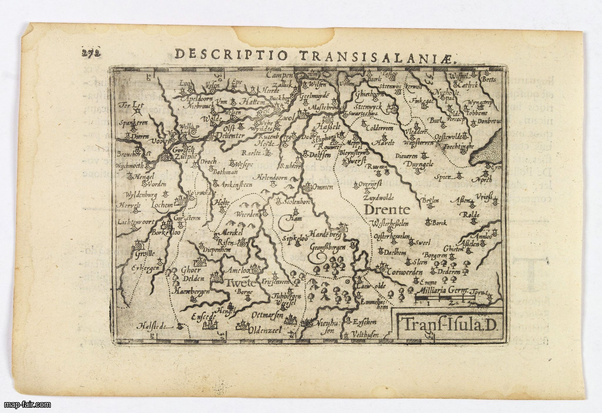
Descriptio Transisalaniae.
BuyNow for $100
- Maker :
- LANGENES, B. / BERTIUS, P.
- Place :
- Amsterdam
- Date :
- 1606
- Color :
- Uncoloured
- Height mm.:
- 85
- Width mm.:
- 125
- Condition :
- In very good condition, lightly age toned, with light water stains, all with wide margins, a nice dark impression. Some show through of text on verso. Latin text to verso.
- Bibliography :
- -
- Seller's ref. :
- 43392
This item is offered by Paulus_Swaen_Old_Maps
See other Items from this seller- Postage
-
Europe
$34 to France
- Select Country
- Zip/Post Code
- Quantity
$100
Description
An original early 17th century copper engraved miniature antique map of the eastern Dutch region of Overijssel by Petrus Bertius.The title is displayed in a simple strapwork cartouche with the further title in bold letters above the map. Zwolle the capital city is engraved, along with Lochem, Zutphen, Apeldoorn, Deventer, Hengelo and Enschede. From the Bertius atlas Tabularum geographicarum contractarum.
Bertius (1565-1629) was a Flemish cartographer, theologian, historian and geographer. Although he published much in the fields of history, theology and mathematics, he is perhaps best known as a cartographer. His works were heavily influenced by the earlier works of Mercator, which date from the late sixteenth century. He was connected by marriage to Jacobus Hondius and Pieter van den Keere, both excellent cartographers, who would influence his later life. He was ‘Cosmographer’ to the court of King Louis XIII.
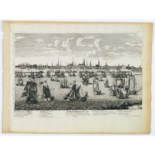
Amsterdam Ville du comté de Hollande. . .
A very decorative and very rare town view of Amsterdam, including a numbered key ( A- T) in the lower part. Engraved by Pierre-Alexandre Aveline. With the signature "Aveline avec privil. du Roy" in the lower right margin. Pierre Aveline (Paris, c.1656 - 23 May 1722), was an engraver, print-publisher and print-seller. He probably trained with Adam Pérelle and specialized in topographical representations like him. He engraved in suites many views of Paris and of provincial, European and African c...
$500
Maker : AVELINE, P.A.
Place : Paris
Date : 1692
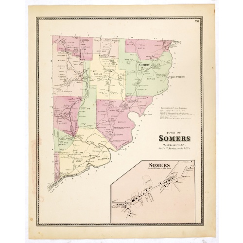
Town of Somers.
Fine lithographed map of the town of Somers. The map provides the names of specific homeowners, as well as information about the occupations and physical locations of the various tradesmen in each village from Beer's famous county atlas "Atlas of New York and vicinity," "a documentary record of nineteenth-century life and delightful specimens of American folk art." F. W. Beers, along with other members of his family, were among the leading county atlas publishers in the period immediately follo...
$90
Maker : DE BEERS, F.W.
Place : New York
Date : 1867
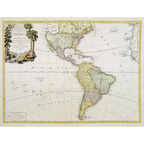
L'Amerique divisée en ses principaux Etats..
Uncommon map published by Lattré. This map is most notable for its depiction of "Mer de L'Ouest" or "Sea of the West". A great sea, easily the size of the Mediterranean, to flow from the then-known Strait of Juan de Fuca. Showing an opening to the ocean from this great sea at roughly in North California or Oregon and Quivira somewhere in Idaho. Fattening Alaska and appropriately leaving blank the unknown parts of Northern America. Listing Indian nations, towns such as Santa Fe.
$900
Maker : JANVIER,Sr.
Place : Paris
Date : 1760

Nieuwe Wassende Graade Zee Kaart over de Spaanse Zee Vant Kanaal tot 't Eyland Cuba in Westindia. . .
¤ Engraved by I.van Anse. A very representative example of a Dutch chart of the Atlantic, showing the north-east coast of America, the coasts of Africa and Europe and South America, including Florida and the West Indies. Gerard issued ca. 40 charts of this exceptionally large format. Collections of these large-size charts were issued in the shining sea-torch and as separate atlases.Title in Dutch, French and English. North America from Labrador to West Florida, including New Foundland, the Gulf...
$3.000
Maker : VAN KEULEN, G.
Place : Amsterdam
Date : 1728
Postage & Shipping
-
Item Location
Terms and conditions - Item Location
- Paris, Ile-de-France, France
- Ships To
- United States, United Kingdom, Albania, Argentina, Armenia, Australia, Azerbaijan, Bahamas, Belgium, Bermuda, Cambodia, Canada, Chile, China, Croatia, Cyprus, Czech Republic, Denmark, Estonia, Finland, France, Germany, Gibraltar, Greece, Greenland, Guatemala, Hong Kong, Iceland, India, Indonesia, Israel, Italy, Japan, Latvia, Lithuania, Luxembourg, Malta, Mexico, Monaco, Netherlands, Norway, Singapore, Spain, Sweden, Switzerland, Turkey
- Pick-ups
- No pick-ups
This item is owned and offered by the seller Paulus_Swaen_Old_Maps - All items are available for immediate sale, offered subject to prior sale.
Invoices are created by the seller by using our shopping cart or be prepared by the seller the day following the order and are emailed to you.
Items offeres by different sellers are invoiced separately.
Shipping fees are extra. The buyer is responsible for all applicable taxes, including any VAT, customs clearance, import duties, or equivalent costs arriving at the customer's home border. Payment is due on receipt of the invoice. The item(s) are shipped as soon as possible after receipt of your payment.
Before buying please read the complete Terms Conditions of Sale.
- Payment Methods
- Visa, Mastercard, Bank Transfer, iDEAL, PayPal
- Returns Accepted
- No
Post Message
Feel free to ask the seller a question. Please note that the seller could be located in an area with a different time zone. Our seller will do their best to respond within 24 hours.Post your message below.
Sign in to ask the seller a question.