ID: 5
Open
Listing ID: #5 has been added to your wishlist.


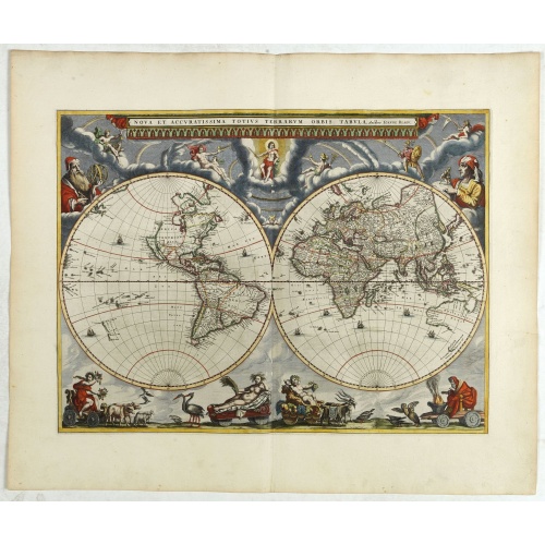
Nova et Accuratissima Totius Terrarum Orbis Tabula.
From his atlas Major.
BuyNow for $17.500
- Maker :
- BLAEU, J.
- Place :
- Amsterdam
- Date :
- 1662
- Color :
- In original colors
- Height mm.:
- 405
- Width mm.:
- 545
- Condition :
- Mint condition with very large margins. French text on verso.
- Bibliography :
- -
- Seller's ref. :
- 42850
This item is offered by Paulus_Swaen_Old_Maps
See other Items from this seller- Postage
-
Standard Shipping
$0 to France
- Select Country
- Zip/Post Code
- Quantity
$17.500
Description
Since its appearance as an Appendix in 1630, the atlas launched by
Willem Blaeu and continued by his son Joan had expanded greatly. But
despite many new regional maps the world map remained unchanged. For
some reason, Joan Blaeu's important wall map of 1648 was not immediately
adapted by his firm for atlas use.
The New
World map prepared by Joan Blaeu for his eleven-volume 'Atlas Maior' in
1662 is, unlike its predecessor, in two hemispheres. Outside the twin
hemispheres at the top are celestial figures seated amid clouds: below
are representations of the four seasons, with each allegorical figure
seated in an appropriate chariot quaintly drawn by pairs of beasts and
birds. As with all productions by the firm of Blaeu, the engraving and
layout and elegance of decoration are all of the highest standards.
-500x500.jpg)
Amstelodamum, Celebre Emporium Forma Plana.
Second state of this rare and decorative plan of Amsterdam with Visscher's imprint. With a panoramic view seen from the IJ and further insets of Council House, The Exchange, House of the Dutch East India Company and House of the West India Company. This state figures the fourth extension with the projected growth of the city added to the left half of the sheet; on the west side, the "Realeneiland" has been extended, above the image of the west India House, the imprint of Visscher has been added,...
$5.000
Maker : VISSCHER, Claes Jansz.
Place : Amsterdam
Date : c. 1636
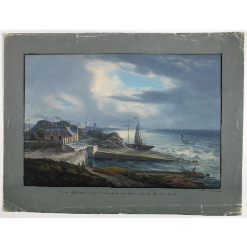
Vue de Gattweick et de l'embouchure du Rhin, dans la Mer du Nord.
Very decorative view of Katwijk. Signed lower right, Louis Bleuler au chateau de Laufen . Original design by Louis Bleuer. This gouache was the model for his aquatint in his famous book 80 Rheingegenden published in 1826.
$1.500
Maker : BLEULER, L.
Place : gERMANY
Date : 1820
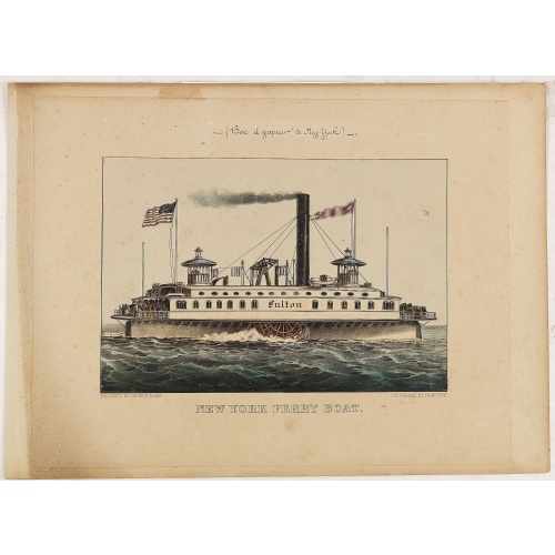
New York Ferry Boat. (Bac à vapeur de New York).
A very decorative print showing the New York Ferry Boat "Fulton," published by Currier & Ives. The Ferry boat "Fulton" sails to the right. A single smokestack trails smoke, and two flags blow to the left. Passengers, horses, and a carriage are visible on deck, and a captain is in the wheelhouse at right.Published by Currier & Ives 125 Nassau Street, New York."Currier & Ives was a New York publishing firm that produced and sold thousands of impressions of more than 7,000 different lithographic pr...
$550
Maker : CURRIER & IVES.
Place : New York
Date : ca. 1875

Descriptio Transisalaniae.
An original early 17th century copper engraved miniature antique map of the eastern Dutch region of Overijssel by Petrus Bertius. The title is displayed in a simple strapwork cartouche with the further title in bold letters above the map. Zwolle the capital city is engraved, along with Lochem, Zutphen, Apeldoorn, Deventer, Hengelo and Enschede. From the Bertius atlas Tabularum geographicarum contractarum. Bertius (1565-1629) was a Flemish cartographer, theologian, historian and geographer. Altho...
$100
Maker : LANGENES, B. / BERTIUS, P.
Place : Amsterdam
Date : 1606
Postage & Shipping
-
Item Location
Terms and conditions - Item Location
- 75013, Ile-de-France, France
- Ships To
- United States, United Kingdom, Albania, Argentina, Armenia, Australia, Azerbaijan, Bahamas, Belgium, Bermuda, Cambodia, Canada, Chile, China, Croatia, Cyprus, Czech Republic, Denmark, Estonia, Finland, France, Germany, Gibraltar, Greece, Greenland, Guatemala, Hong Kong, Iceland, India, Indonesia, Israel, Italy, Japan, Latvia, Lithuania, Luxembourg, Malta, Mexico, Monaco, Netherlands, Norway, Singapore, Spain, Sweden, Switzerland, Turkey
- Pick-ups
- Buyer can pick-up
This item is owned and offered by the seller Paulus_Swaen_Old_Maps - All items are available for immediate sale, offered subject to prior sale.
Invoices are created by the seller by using our shopping cart or be prepared by the seller the day following the order and are emailed to you.
Items offeres by different sellers are invoiced separately.
Shipping fees are extra. The buyer is responsible for all applicable taxes, including any VAT, customs clearance, import duties, or equivalent costs arriving at the customer's home border. Payment is due on receipt of the invoice. The item(s) are shipped as soon as possible after receipt of your payment.
Before buying please read the complete Terms Conditions of Sale.
- Payment Methods
- Visa, Mastercard, Bank Transfer, American Express, iDEAL, PayPal, Google Pay
- Returns Accepted
- No
Post Message
Feel free to ask the seller a question. Please note that the seller could be located in an area with a different time zone. Our seller will do their best to respond within 24 hours.Post your message below.
Sign in to ask the seller a question.