
ID: 308
Closed
Listing ID: #308 has been added to your wishlist.
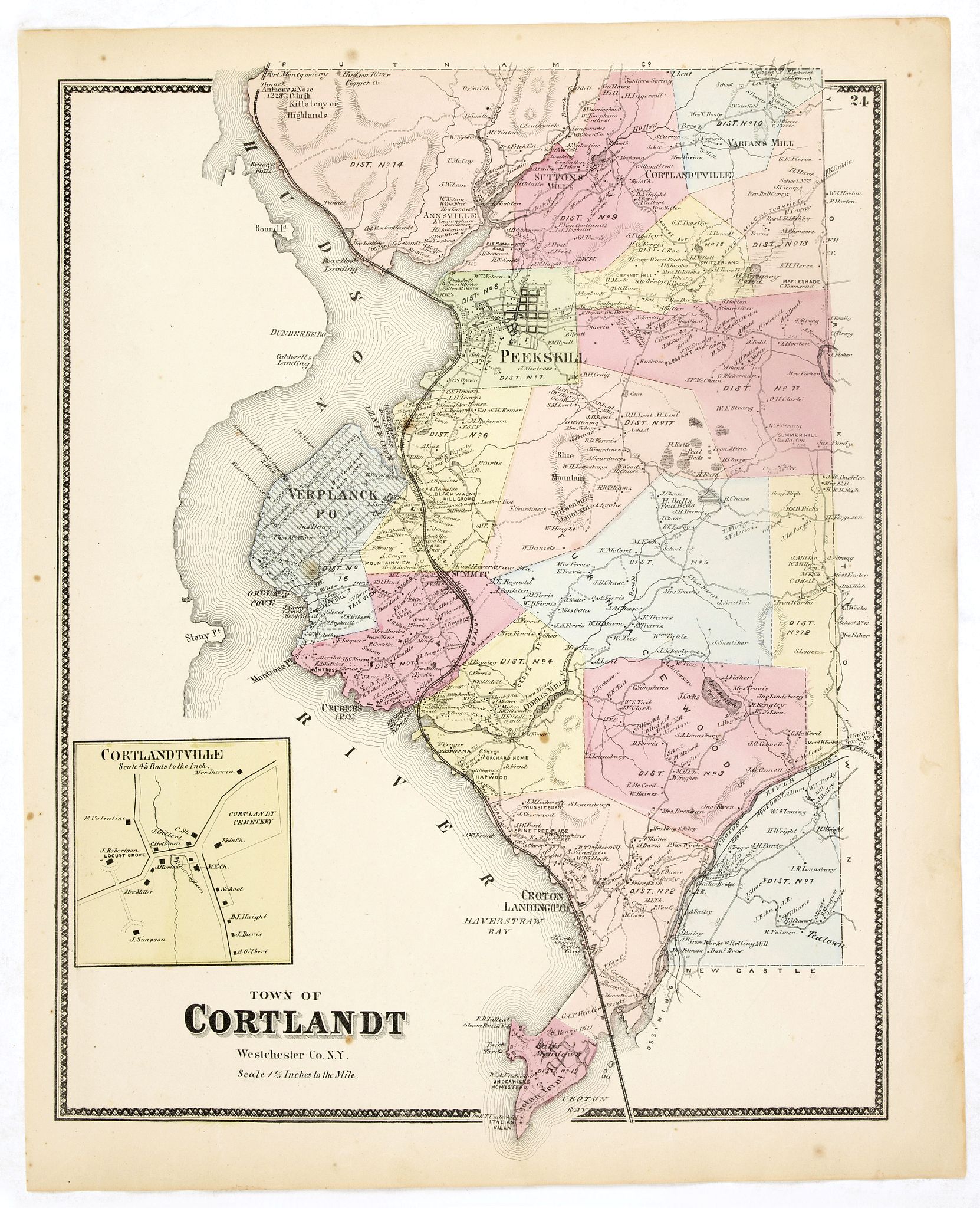
Town of Cortlandt.
BuyNow for $90
- Maker :
- DE BEERS, F.W.
- Place :
- New York
- Date :
- 1867
- Color :
- Original colors
- Height mm.:
- 405
- Width mm.:
- 320
- Condition :
- Some very light spotting but generally in very good condition.
- Bibliography :
- Barbara B. McCorkle 'The Strange Case of F.W. Beers and The Atlas of New York and Vicinity' in Meridian 5, pp.39-43. cf. Phillips 2290; cf. Rumsey 4631. Ristow, American Maps and Mapmakers, chapter 25.
- Seller's ref. :
- 37657
This item is offered by Paulus_Swaen_Old_Maps
See other Items from this seller- Postage
-
Europe
$35 to France
- Select Country
- Zip/Post Code
- Quantity
$90
Description
Fine lithographed map of the town of Cortlandt. The map provides the names of specific homeowners, as well as information about the occupations and physical locations of the various tradesmen in each village from Beer's famous county atlas "Atlas of New York and vicinity", "a documentary record of nineteenth-century life and delightful specimens of American folk art."
F. W. Beers, along with other members of his family, were among the leading county atlas publishers in the period immediately following the Civil War. Their atlases provide "a detailed cartographical, biographical, and pictorial record of a large segment of rural America in the Victorian age" (Ristow).
Beers first published his Atlas of New York & Vicinity in 1867.
Shows townships, roads, railroads, radial distances. "Atlas of New York and vicinity" published by Beers, Ellis & Soule, 95 Maiden Lane, New York.

Lyste vande prysen der goederen ingekoft by de Kamer. . .
Rare price list of meat, bacon, wheat, rye, butter, cheese, olive oil, Spanish wines, Bordeaux, brandy etc.On front page in letter press Lyste Van de Pryfen der Goederen, Ingekofst by de Kamer van de OOST-INDISCHE COMPAGNIE tot Gestelt na de datums van der zelver inkoop.Dated in manuscript 1685. Rare pricelist of articles purchased by the V.O.C. over the year 1685. Including large quantities of French wines!. Very rare.
$2.500
Maker : V.O.C.
Place : Amsterdam
Date : 1685

Eastern passage to China. sheet 1.
James Horsburgh early chart of the coasts of Java, Bali, Lombok, with part of Sulawesi, and Borneo. Insets of "Sketch of Bally Strait", Sketch of Lombock Strait", Plan of Allas Strait", "Sketch of Sappy Strait".The chart shows depth soundings & both topographical and hydrographical details and proposed sailing directions in the Sunda Straits. Filled with several coastal profiles, which were of great help for the sailor.In top Horsburgh thanks for the aid he has gotten for preparing this chart : ...
$3.000
Maker : HORSBURGH, JAMES, F.R.S
Place : London
Date : 1824

Mappe-Monde pour connoitre les progres & les conquestes..
Unusual double hemisphere map with California as an Island. Dutch text describes the expeditions and colonial possessions of the Dutch East India Company. The map originated in about 1670. Chatelain acquired the plate; he added decorative elements, including sailing ships, the Dutch crest, and a figure representing Europa seated inside a native fort.Zacharie Chatelain (d.1723) was the father of Henri Abraham (1684-1743) and Zacharie Junior (1690-1754).They worked as a partnership publishing the ...
$800
Maker : CHATELAIN, H.
Place : Amsterdam
Date : 1729

Brabantiae Descriptio.
In an inset Mechelen and surroundings. Decorative scale and title cartouche with dedicational initials, which may refer to Laurentius Michaelis, who may be connected with the Mechelen inset map.Dare to go in Black. All early maps were printed in black and white, and many were kept that way for a long time. A black and white map in an early and strong impression is a rarity nowadays, being so many examples recently colored up!
$350
Maker : ORTELIUS, A.
Place : Antwerp, 1598
Date : 1598
Postage & Shipping
-
Item Location
Terms and conditions - Item Location
- 75013, Ile-de-France, France
- Ships To
- United States, United Kingdom, Albania, Argentina, Armenia, Australia, Azerbaijan, Bahamas, Belgium, Bermuda, Cambodia, Canada, Chile, China, Croatia, Cyprus, Czech Republic, Denmark, Estonia, Finland, France, Germany, Gibraltar, Greece, Greenland, Guatemala, Hong Kong, Iceland, India, Indonesia, Israel, Italy, Japan, Latvia, Lithuania, Luxembourg, Malta, Mexico, Monaco, Netherlands, Norway, Singapore, Spain, Sweden, Switzerland, Turkey
- Pick-ups
- No pick-ups
This item is owned and offered by the seller Paulus_Swaen_Old_Maps - All items are available for immediate sale, offered subject to prior sale.
Invoices are created by the seller by using our shopping cart or be prepared by the seller the day following the order and are emailed to you.
Items offeres by different sellers are invoiced separately.
Shipping fees are extra. The buyer is responsible for all applicable taxes, including any VAT, customs clearance, import duties, or equivalent costs arriving at the customer's home border. Payment is due on receipt of the invoice. The item(s) are shipped as soon as possible after receipt of your payment.
Before buying please read the complete Terms Conditions of Sale.
- Payment Methods
- Visa, Mastercard, Bank Transfer, American Express, iDEAL, PayPal, Google Pay
- Returns Accepted
- No
Post Message
Feel free to ask the seller a question. Please note that the seller could be located in an area with a different time zone. Our seller will do their best to respond within 24 hours.Post your message below.
Sign in to ask the seller a question.
