
ID: 110
Closed
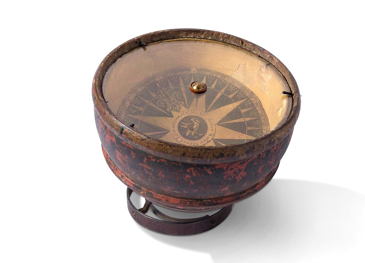
Mariner’s compass
BuyNow for $3.000
- Maker :
- MANN
- Place :
- Liverpool
- Date :
- ca. 1785
- Color :
- Uncolored.
- Height mm.:
- 170
- Width mm.:
- 170
- Condition :
- In original wooden case, in gimbals and oak surround. Dated in pencil ''1785''.
- Bibliography :
- -
- Seller's ref. :
- 48676
This item is offered by Paulus_Swaen_Old_Maps
See other Items from this seller- Postage
-
Standard Shipping
$0 to Netherlands
- Select Country
- Zip/Post Code
- Quantity
$3.000
Description
Inverted compass called "snitch" in wood painted in imitation of tortoiseshell and brass, signed "Ing MANN Maker Water Street Liverpool".
Straat Riouw onder opzicht van de commissie tot verbetering der Indische Zeekaarten..
Very large and rare so-called Blue Back chart centered on the strait passing between the Riau Islands. It contains an inset map with enlarged details of Riouw Harbor on Bintang Island.Coastal profiles are shown in the lower-left corner of the chart.The chart is prepared by W.H.Dittlof Tjassens, P.A.J.Bloijs van Treslong Prins and J.van Gogh during an expedition in 1840 by the ship Nehalennia under the command of Captain F.G.van der Plaat. The chart is engraved by D.Veelwaard Jr. And published in...
$1.250
Maker : HULST VAN KEULEN, Wed.G.
Place : Amsterdam
Date : 1843

Lyste vande prysen der goederen ingekoft by de Kamer. . .
Rare price list of meat, bacon, wheat, rye, butter, cheese, olive oil, Spanish wines, Bordeaux, brandy etc.On front page in letter press Lyste Van de Pryfen der Goederen, Ingekofst by de Kamer van de OOST-INDISCHE COMPAGNIE tot Gestelt na de datums van der zelver inkoop.Dated in manuscript 1685. Rare pricelist of articles purchased by the V.O.C. over the year 1685. Including large quantities of French wines!. Very rare.
$2.500
Maker : V.O.C.
Place : Amsterdam
Date : 1685

A new mape of Ye XVII Provinces of Low Germanie.
Showing all 17 Provinces of the Netherlands before the split between Spain and the Protestant Provinces under the House of Orange.The map was first published. At the same time, the war of independence was still being fought against Philip II. With columns of figures on either side and surmounted by eight city prospects. A famous and most decorative item.A fourth state published by Thomas Basset and Richard Chiswell. The date has been removed and Speed's name has been added to the title cartouche...
$2.300
Maker : SPEED, J.
Place : London, 1676
Date : 1626

Gelriae, Cliviae, Finitimorumque Locorum Verissima..
East to the top. Fine map of Geldria and Limburg, prepared by Christian s'Grooten. Very fine title cartouche lower right with painter's utensils around the cartouche.Dare to go in Black. All early maps were printed in black and white, and many were kept that way for a long time. A black and white map in an early and strong impression is a rarity nowadays, being so many examples recently colored up!
$250
Maker : ORTELIUS, A.
Place : Antwerp
Date : 1598
Postage & Shipping
-
Item Location
Terms and conditions - Item Location
- 75013, Ile-de-France, France
- Ships To
- United States, United Kingdom, Albania, Argentina, Armenia, Australia, Azerbaijan, Bahamas, Belgium, Bermuda, Cambodia, Canada, Chile, China, Croatia, Cyprus, Czech Republic, Denmark, Estonia, Finland, France, Germany, Gibraltar, Greece, Greenland, Guatemala, Hong Kong, Iceland, India, Indonesia, Israel, Italy, Japan, Latvia, Lithuania, Luxembourg, Malta, Mexico, Monaco, Netherlands, Norway, Singapore, Spain, Sweden, Switzerland, Turkey
- Pick-ups
- No pick-ups
This item is owned and offered by the seller Paulus_Swaen_Old_Maps - All items are available for immediate sale, offered subject to prior sale.
Invoices are created by the seller by using our shopping cart or be prepared by the seller the day following the order and are emailed to you.
Items offeres by different sellers are invoiced separately.
Shipping fees are extra. The buyer is responsible for all applicable taxes, including any VAT, customs clearance, import duties, or equivalent costs arriving at the customer's home border. Payment is due on receipt of the invoice. The item(s) are shipped as soon as possible after receipt of your payment.
Before buying please read the complete Terms Conditions of Sale.
- Payment Methods
- Visa, Mastercard, Bank Transfer, American Express, iDEAL, PayPal, Google Pay
- Returns Accepted
- No
Post Message
Feel free to ask the seller a question. Please note that the seller could be located in an area with a different time zone. Our seller will do their best to respond within 24 hours.Post your message below.
Sign in to ask the seller a question.
