ID: 334
Open
Listing ID: #334 has been added to your wishlist.
![[Religious ritual on Hispaniola].](/uploads/39921.jpg)
[Religious ritual on Hispaniola].
BuyNow for $80
- Maker :
- GOTTFRIED, J.L. / DE BRY.
- Place :
- Frankfurt, M.Merian
- Date :
- 1633
- Color :
- Uncolored
- Height mm.:
- 162
- Width mm.:
- 192
- Condition :
- Copper plate engraving on text sheet. Paper browned as usual. Right margin slightly cropped. White tape over an old tear to bottom margin.
Size of sheet : 345 x 212 mm. German text on verso. German text on verso. - Bibliography :
- www.history-engraved.org/ Hispaniola 540
- Seller's ref. :
- 39921
This item is offered by Paulus_Swaen_Old_Maps
See other Items from this seller- Postage
-
Europe
$34 to France
- Select Country
- Zip/Post Code
- Quantity
$80
Description
Scarce print with a German text sheet.On certain feast-days the Indian cacique, while beating a drum, led a procession of his people to the worship of their idol, which was a strange hybrid-like creature with several heads.The men were painted black, red and yellow and came first, dressed in parrot feathers and necklaces of seashells. The women, decorated with jewellery, followed with their naked daughters. When all were assembled, the cacique inserted a stake into his throat, which made him vomit, so as to rid himself of secrets.
While the men sat cross-legged, chanting, the women brought baskets of bread and roses in adoration of their idol From de Bry's "Great American Voyages".
Johann Theodor de Bry (1561-1623) was born in Liège in 1561, the eldest son of the engraver and publisher Theodor de Bry. It was from his father that Johann learned his craft, producing both engravings and etchings.
In 1588, the Lutheran De Bry family settled in Frankfurt am Main, a safe haven for Lutherans at this time of religious discord. Together with his father and brother (Johann Israël de Bry), Johann published two popular emblem books.
He also produced engravings from celebrated contemporary painters. De Bry died in Frankfurt in 1623.

Pas kaart Van Rio Oronoque Golfo De Paria met d'Eylanden Trinidad, Tabago, Granada, Granadillos, en Bequia . . .
A highly detailed and rare sea chart of the mouth of the Orinoco River, Trinidad, Tabago, St.Vincent and neighboring islands. Oriented with north to the right by two compass roses.A large inset shows Tobago on a larger scale. Taken from De Nieuwe Groote Lichtende Zee-Fakkel, Part IV.Decorative scale cartouche features Neptune with his entourage and natives with trade goods. The chart is further adorned with a monkey atop the title cartouche and a sailing ship.
$900
Maker : VAN KEULEN, J.
Place : Amsterdam
Date : 1684

Carta esférica del Rio de la Plata : desde su embocadura hasta Buenos Aires.
Large nautical chart illustrating the estuary formed by the combination of the Uruguay River and the Paraná River. It forms part of the border between Argentina and Uruguay, with the major ports and capital cities of Buenos Aires in the southwest and Montevideo in the northeast.
$750
Maker : DIRECTION HIDROGRAFICA
Place : Madrid
Date : 1812-1838
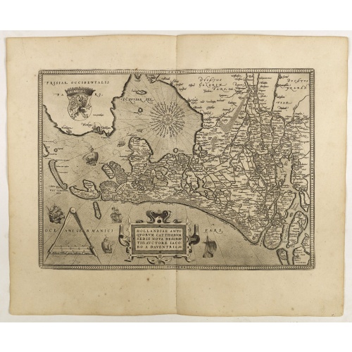
Hollandiae Antiquorum Catthorum..
This map shows Holland in great detail, including small towns, walled cities, rivers and lakes (many of which were reclaimed in the 17th century, and no longer exist). A coat of arms is in the upper left corner of the map image. In the ocean, there are many sailing ships and smaller fishing boats. An intricate compass rose is in the upper middle area. A very decorative map of the Dutch provinces of Friesland, Groningen and Drente and of the German Province of Friesland.
$750
Maker : ORTELIUS, A.
Place : Antwerp
Date : 1598
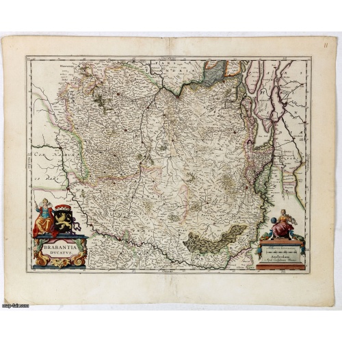
Brabantia Ducatus.
A very decorative map by Willem Blaeu with west is at the top. On the lower left a magnificent cartouche with a sitting female figure carrying a globe and compasses and the coat of arms of Brabant. The map encloses the area between the rivers Rhine, Meuse and Scheldt, with Namur (Namen) as the most southern town.
$400
Maker : BLAEU, W.
Place : Amsterdam, 1645
Date : 1645
Postage & Shipping
-
Item Location
Terms and conditions - Item Location
- Clearwater, Florida, United States
- Ships To
- United States, United Kingdom, Albania, Argentina, Armenia, Australia, Azerbaijan, Bahamas, Belgium, Bermuda, Cambodia, Canada, Chile, China, Croatia, Cyprus, Czech Republic, Denmark, Estonia, Finland, France, Germany, Gibraltar, Greece, Greenland, Guatemala, Hong Kong, Iceland, India, Indonesia, Israel, Italy, Japan, Latvia, Lithuania, Luxembourg, Malta, Mexico, Monaco, Netherlands, Norway, Singapore, Spain, Sweden, Switzerland, Turkey
- Pick-ups
- No pick-ups
This item is owned and offered by the seller Paulus_Swaen_Old_Maps - All items are available for immediate sale, offered subject to prior sale.
Invoices are created by the seller by using our shopping cart or be prepared by the seller the day following the order and are emailed to you.
Items offeres by different sellers are invoiced separately.
Shipping fees are extra. The buyer is responsible for all applicable taxes, including any VAT, customs clearance, import duties, or equivalent costs arriving at the customer's home border. Payment is due on receipt of the invoice. The item(s) are shipped as soon as possible after receipt of your payment.
Before buying please read the complete Terms Conditions of Sale.
- Payment Methods
- Visa, Mastercard, Bank Transfer, American Express, iDEAL, PayPal, Google Pay
- Returns Accepted
- No
Post Message
Feel free to ask the seller a question. Please note that the seller could be located in an area with a different time zone. Our seller will do their best to respond within 24 hours.Post your message below.
Sign in to ask the seller a question.
![[Religious ritual on Hispaniola].](/uploads/cache/39921-500x500.jpg)