
ID: 283
Open
Listing ID: #283 has been added to your wishlist.
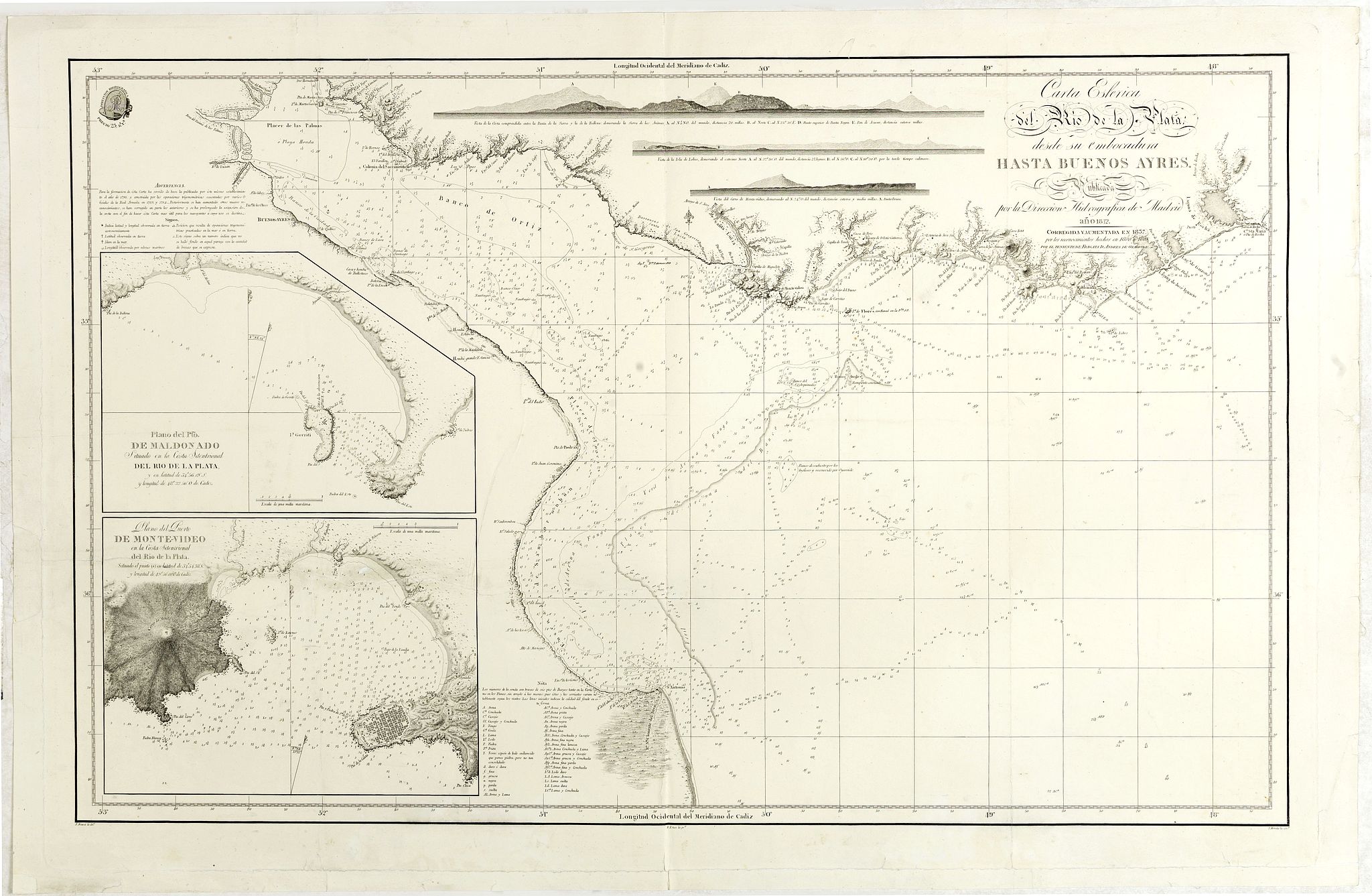
Carta esférica del Rio de la Plata : desde su embocadura hasta Buenos Aires.
BuyNow for $750
- Maker :
- DIRECTION HIDROGRAFICA
- Place :
- Madrid
- Date :
- 1812-1838
- Color :
- Uncolored
- Height mm.:
- 565
- Width mm.:
- 888
- Condition :
- Left and lower neat line reinforced. Repair of horizontal tear in lower left part, 45 cm into the engraved area. Repair of a small tear attaining the upper right border frame.
- Bibliography :
- -
- Seller's ref. :
- 42521
This item is offered by Paulus_Swaen_Old_Maps
See other Items from this seller- Postage
-
Europe
$34 to France
- Select Country
- Zip/Post Code
- Quantity
$750
Description
Large nautical chart illustrating the estuary formed by the combination of the Uruguay River and the Paraná River.It forms part of the border between Argentina and Uruguay, with the major ports and capital cities of Buenos Aires in the southwest and Montevideo in the northeast.
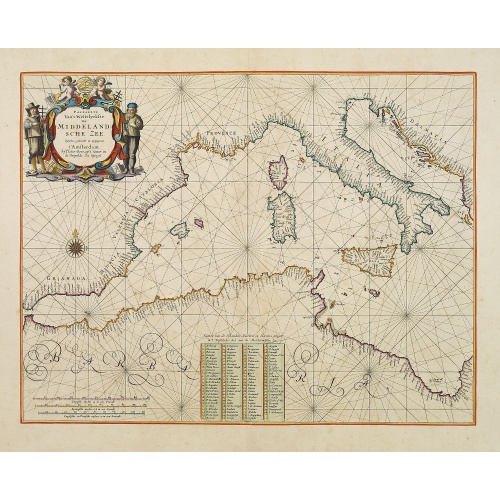
Pascaerte Van't Westelyckste der Middelandsche Zee. . .
An eye-catching chart of the western part of the Mediterranean Sea.Pieter Goos (ca. 1616-1675) was one of the most important cartographer, engraver, publisher and print seller of Amsterdam. His widow continued business at her husband's death. She re-issued the Nieuwe Groote Zee-Spiegel in 1676.In very decorative original colors. The compass rose and cartouche heightened with gold.The map is in a strictly contemporary coloring and of the highest level.
$3.750
Maker : GOOS, P.
Place : Amsterdam
Date : 1666
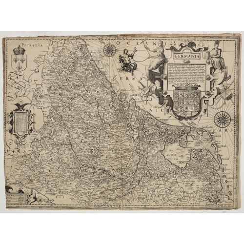
Inferior Germania.
Very rare map of the Benelux, centered on the Netherlands. According to van der Heijden only known in 6 examples. Two compass-roses with rumb lines but without the names of the wind directions. Very decorative title cartouche with legend, and underneath a large escutcheon with the coats-of-arms of all the XVII Provinces.The maps shows a striking resemblance, also in details, the one by Jodocus Hondius of 1593 and to the map in four sheets of 1602. For the greater part the text in the title carto...
$4.500
Maker : ANONYMOUS / HONDIUS, J. ?
Place : Amsterdam
Date : ca. 1600
![[Murder of Dominican monks in Cumana or Cubagua Island].](/uploads/cache/40177-500x500.jpg)
[Murder of Dominican monks in Cumana or Cubagua Island].
Murder of Dominican monks in Cumana or Cubagua Island in what is now Venezuela. Scarce print (150x177mm.) on a German text sheet taken from a first edition of Johann Ludwig Gottfried's "Newe Welt Vnd Americanische Historien/ Jnhaltende Warhafftige vnd volkommene Beschreibungen Aller West-Indianischen Landschafften…" published by M.Merian in 1631.
$80
Maker : GOTTFRIED, J.L. / DE BRY, T.
Place : Frankfurt, M.Merian
Date : 1633
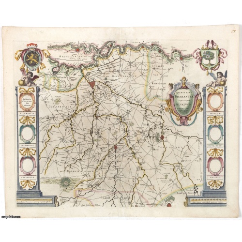
Quarta pars Brabantiae cujus caput Sylvaducis.
The coat of arms of Brabant and 's-Hertogenbosch do appear on the map. But the municipal arms in the columns on right and left-hand side have not yet been filled in. The map was prepared by Willibrordus van der Burgt.Considered one of the most decorative maps published by the publishing house of Blaeu.
$750
Maker : BLAEU, W.
Place : Amsterdam
Date : 1645
Postage & Shipping
-
Item Location
Terms and conditions - Item Location
- 75013, Ile-de-France, France
- Ships To
- United States, United Kingdom, Albania, Argentina, Armenia, Australia, Azerbaijan, Bahamas, Belgium, Bermuda, Cambodia, Canada, Chile, China, Croatia, Cyprus, Czech Republic, Denmark, Estonia, Finland, France, Germany, Gibraltar, Greece, Greenland, Guatemala, Hong Kong, Iceland, India, Indonesia, Israel, Italy, Japan, Latvia, Lithuania, Luxembourg, Malta, Mexico, Monaco, Netherlands, Norway, Singapore, Spain, Sweden, Switzerland, Turkey
- Pick-ups
- No pick-ups
This item is owned and offered by the seller Paulus_Swaen_Old_Maps - All items are available for immediate sale, offered subject to prior sale.
Invoices are created by the seller by using our shopping cart or be prepared by the seller the day following the order and are emailed to you.
Items offeres by different sellers are invoiced separately.
Shipping fees are extra. The buyer is responsible for all applicable taxes, including any VAT, customs clearance, import duties, or equivalent costs arriving at the customer's home border. Payment is due on receipt of the invoice. The item(s) are shipped as soon as possible after receipt of your payment.
Before buying please read the complete Terms Conditions of Sale.
- Payment Methods
- Visa, Mastercard, Bank Transfer, American Express, iDEAL, PayPal, Google Pay
- Returns Accepted
- No
Post Message
Feel free to ask the seller a question. Please note that the seller could be located in an area with a different time zone. Our seller will do their best to respond within 24 hours.Post your message below.
Sign in to ask the seller a question.

![Westelijk Halfrond. [Western hemisphere]](/uploads/cache/25524-500x500.jpg)
