ID: 320
Open
Listing ID: #320 has been added to your wishlist.
![[Murder of Dominican monks in Cumana or Cubagua Island].](/uploads/40177.jpg)
[Murder of Dominican monks in Cumana or Cubagua Island].
BuyNow for $80
- Maker :
- GOTTFRIED, J.L. / DE BRY, T.
- Place :
- Frankfurt, M.Merian
- Date :
- 1633
- Color :
- Uncolored
- Height mm.:
- 150
- Width mm.:
- 175
- Condition :
- Copper plate engraving on text sheet. Paper slightly browned, as usual. Size of sheet : 345 x 215 mm. German text on verso.
- Bibliography :
- -
- Seller's ref. :
- 40177
This item is offered by Paulus_Swaen_Old_Maps
See other Items from this seller- Postage
-
Europe
$34 to France
- Select Country
- Zip/Post Code
- Quantity
$80
Description
Murder of Dominican monks in Cumana or Cubagua Island in what is now Venezuela. Scarce print (150x177mm.) on a German text sheet taken from a first edition of Johann Ludwig Gottfried's "Newe Welt Vnd Americanische Historien/ Jnhaltende Warhafftige vnd volkommene Beschreibungen Aller West-Indianischen Landschafften…" published by M.Merian in 1631.![[Printed on silk] Nieuw Wassende Graaden Paskaart Vertoonende alle de bekende Zeekusten en Landen op den geheelen Aard Boodem of Werelt door Gerard van Keulen. . .](/uploads/cache/31640-500x500.jpg)
[Printed on silk] Nieuw Wassende Graaden Paskaart Vertoonende alle de bekende Zeekusten en Landen op den geheelen Aard Boodem of Werelt door Gerard van Keulen. . .
A very scarce and beautiful chart on Mercator's projection printed on silk. The map is printed on silk. With the name of Gerard van Keulen and the privilege. The map shows great interior detail, including a well-formed depiction of the Great Lakes and Mississippi River. Fort de Creveceur is shown near the Illinois River. The east coast of Siberia has been drawn after Nicolas Witsen's 1687 map of Tartary. A Great Companies Land has been added off the northwest coast of America. California is an i...
$20.000
Maker : VAN KEULEN, G.
Place : Amsterdam
Date : 1728
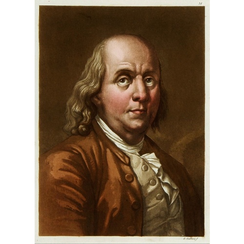
Portrait de Benjamin Franklin.
Portrait de Benjamin Franklin. From Giulio Ferrario's work Le Costume ancien et moderne ou histoire du gouvernement, de la milice, de la religion, des arts, etc. published in Milan by the author between 1816 and 1827.This aquatint engraved plate was color printed on fine wove paper of a soft aged white color, bearing the embossed seal of authenticity impressed at the time of publication with the legend “Il Costume Antico E Moderno” surrounding the initials GF. A beautifully hand colored aq...
$75
Maker : FERRARIO, G.
Place : Milan, 1827
Date : 1827
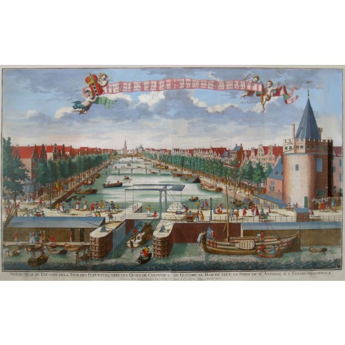
Beschrijving Gezicht van den Ykant af bezyden den Schreiers hoex Toren langs de Keulsche en Geldersche Kaei naer de Nieuwe Markt
This large engraving (560x920mm.) comes from a are series of 25 beautiful large views of Amsterdam and gives a colorful picture of the life and business of the city at the beginning of the 18th century. The print gives a view of the cityscape and architecture of that time. It also shows daily manners and customs and all kinds of scenes take place; There is a fight to the left of the bridge in the foreground (now Prins Hendrik Kade), while in front of the Scheierstoren quiet citizens read the not...
$2.000
Maker : DE LETH, H.
Place : Amsterdam
Date : ca 1720

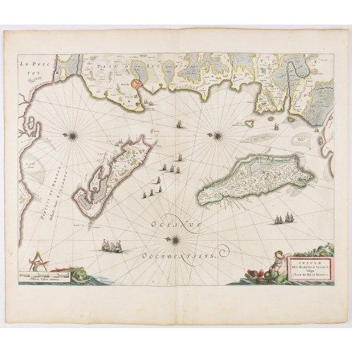
Universe Europae Maritime Eiusque Navigationis Descriptio. Generale Pascaerte van Europa . . .
This general chart of north-western Europe and the surrounding coastal waters is from the rare pilot-guide De Spiegel der Zeevaerdt , printed by Christopher Plantin in Leyden.FIRST PLATE AND FIRST STATE, which appeared in the first 3 editions, before Latin names of some seas and inscriptions in the scale bars were added. (editions 4-12). EXTREMELY RARE.The map's title is given in both Latin and Dutch, with the latter attributing it to Waghenaer and nothing a privilege of ten years. The date 1583...
$25.000
Maker : WAGHENAER, L.J.
Place : Leyden
Date : 1584
Postage & Shipping
-
Item Location
Terms and conditions - Item Location
- Amsterdam, , Netherlands
- Ships To
- United States, United Kingdom, Albania, Argentina, Armenia, Australia, Azerbaijan, Bahamas, Belgium, Bermuda, Cambodia, Canada, Chile, China, Croatia, Cyprus, Czech Republic, Denmark, Estonia, Finland, France, Germany, Gibraltar, Greece, Greenland, Guatemala, Hong Kong, Iceland, India, Indonesia, Israel, Italy, Japan, Latvia, Lithuania, Luxembourg, Malta, Mexico, Monaco, Netherlands, Norway, Singapore, Spain, Sweden, Switzerland, Turkey
- Pick-ups
- No pick-ups
This item is owned and offered by the seller Paulus_Swaen_Old_Maps - All items are available for immediate sale, offered subject to prior sale.
Invoices are created by the seller by using our shopping cart or be prepared by the seller the day following the order and are emailed to you.
Items offeres by different sellers are invoiced separately.
Shipping fees are extra. The buyer is responsible for all applicable taxes, including any VAT, customs clearance, import duties, or equivalent costs arriving at the customer's home border. Payment is due on receipt of the invoice. The item(s) are shipped as soon as possible after receipt of your payment.
Before buying please read the complete Terms Conditions of Sale.
- Payment Methods
- Visa, Mastercard, Bank Transfer, American Express, iDEAL, PayPal, Google Pay
- Returns Accepted
- No
Post Message
Feel free to ask the seller a question. Please note that the seller could be located in an area with a different time zone. Our seller will do their best to respond within 24 hours.Post your message below.
Sign in to ask the seller a question.
![[Murder of Dominican monks in Cumana or Cubagua Island].](/uploads/cache/40177-500x500.jpg)
-500x500.jpg)