ID: 98
Open
[Printed on silk] Nieuw Wassende Graaden Paskaart Vertoonende alle de bekende Zeekusten en Landen op den geheelen Aard Boodem of Werelt door Gerard van Keulen. . .
BuyNow for $20.000
- Maker :
- VAN KEULEN, G.
- Place :
- Amsterdam
- Date :
- 1728
- Color :
- Uncoloured
- Height mm.:
- 580
- Width mm.:
- 990
- Condition :
- Printed on silk for portability. Verso reinforced on several places due to the fragility of silk and backed with fragile Japan paper for protective reasons. Very dark impression. Very good condition throughout because the map is printed on silk.
- Bibliography :
- Koeman, Atlantes Neerlandici, IV,p.382
- Seller's ref. :
- 31640
This item is offered by Paulus_Swaen_Old_Maps
See other Items from this seller- Postage
-
Standard Shipping
$0 to Netherlands
- Select Country
- Zip/Post Code
- Quantity
$20.000
Description
A very scarce and beautiful chart on Mercator's projection printed on silk. The map is printed on silk. With the name of Gerard van Keulen and the privilege. The map shows great interior detail, including a well-formed depiction of the Great Lakes and Mississippi River. Fort de Creveceur is shown near the Illinois River. The east coast of Siberia has been drawn after Nicolas Witsen's 1687 map of Tartary. A Great Companies Land has been added off the northwest coast of America. California is an island.The map is beautifully decorated in the upper left is a title cartouche, personifications of the continents, and native flora and fauna. At the lower left is a secondary cartouche set in the middle of an ocean with sea nymphs and the figure of Poseidon.
[Cavendish reaches Morro Moreno.]
Scarce print with a German text sheet showing Cavendish’s fleet anchor at a place called Morro Moreno, on the coast of Chile. The Indians came down from the high cliffs to greet the voyagers and brought with them firewood and fresh water as a sign of friendship. Later the English were taken to their homes, which were made from two sticks in the ground, with others laid across and covered with straw. The whole family, including children, lay underneath on animal skins. They were skilled fisherm...
$80
Maker : GOTTFRIED, J.L. / DE BRY.
Place : Frankfurt, M.Merian
Date : 1633
Virulus marinus. Cete (Whale and whaling scene)
Whale and whaling scene, set against a mountainous landscape in the manner of Pieter Brueghel the Elder. Plate number 1. The engraving is copied after Adrian Collaert plate in "Piscium Vivæ Icones" a series first published in Antwerp by Adriaen Collaert after 1598, later published between 1627 and 1677 by Galle family. Several copies were made of this series.Most of the ships in the background were copied from a series of ten prints known as the Sailing Vessels, executed by Frans Huys after des...
$300
Maker : COLLAERT, Adriaen (after)
Place : Antwerp
Date : after 1598
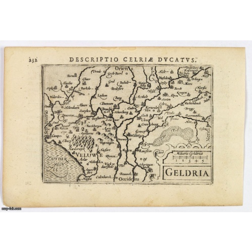
Geldria.
An original early 17th century copper engraved miniature antique map of the Dutch province of Gelderland by Petrus Bertius, that was published in Amsterdam at the beginning of the seventeenth century. Shows extensive river systems, hills, towns and cities, sea hatching in the Zyder Zee and a strapwork title. Cities include: Arnhem, Nijmegen, Zutphen, Harderwijk. North is orientated to the left. From the Bertius atlas Tabularum geographicarum contractarum. Bertius (1565-1629) was a Flemish cartog...
$100
Maker : LANGENES, B. / BERTIUS, P.
Place : Amsterdam, 1606
Date : 1606
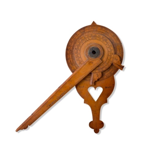
Nocturnal in boxwood and brass.
Nocturlabe in boxwood and brass, the wheels maintained by a central nut presenting an annual calendar divided into months and days, an hour disc and a mobile alidade, the back engraved with a compass rose.The grip is openwork with a heart inscribed "Both Bears" for the Big and Little Dipper.England, circa 1700.Height without the alidade : 21,5 cm - Height in total : 26 cmNocturnal (sometimes called a ""horologium nocturnum" - time instrument for the night) in boxwood and brass, the wheels held ...
$15.000
Maker : COOPER, Th.
Place : England, Thomas Cooper
Date : dated 1701
Postage & Shipping
-
Item Location
Terms and conditions - Item Location
- Amsterdam, , Netherlands
- Ships To
- United States, United Kingdom, Albania, Argentina, Armenia, Australia, Azerbaijan, Bahamas, Belgium, Bermuda, Cambodia, Canada, Chile, China, Croatia, Cyprus, Czech Republic, Denmark, Estonia, Finland, France, Germany, Gibraltar, Greece, Greenland, Guatemala, Hong Kong, Iceland, India, Indonesia, Israel, Italy, Japan, Latvia, Lithuania, Luxembourg, Malta, Mexico, Monaco, Netherlands, Norway, Singapore, Spain, Sweden, Switzerland, Turkey
- Pick-ups
- No pick-ups
This item is owned and offered by the seller Paulus_Swaen_Old_Maps - All items are available for immediate sale, offered subject to prior sale.
Invoices are created by the seller by using our shopping cart or be prepared by the seller the day following the order and are emailed to you.
Items offeres by different sellers are invoiced separately.
Shipping fees are extra. The buyer is responsible for all applicable taxes, including any VAT, customs clearance, import duties, or equivalent costs arriving at the customer's home border. Payment is due on receipt of the invoice. The item(s) are shipped as soon as possible after receipt of your payment.
Before buying please read the complete Terms Conditions of Sale.
- Payment Methods
- Visa, Mastercard, Bank Transfer, American Express, iDEAL, PayPal, Google Pay
- Returns Accepted
- No
Post Message
Feel free to ask the seller a question. Please note that the seller could be located in an area with a different time zone. Our seller will do their best to respond within 24 hours.Post your message below.
Sign in to ask the seller a question.

![[Printed on silk] Nieuw Wassende Graaden Paskaart Vertoonende alle de bekende Zeekusten en Landen op den geheelen Aard Boodem of Werelt door Gerard van Keulen. . .](/assets/images/image-loading.svg)
![[Cavendish reaches Morro Moreno.]](/uploads/cache/39910-500x500.jpg)
-500x500.jpg)


![[Printed on silk] Nieuw Wassende Graaden Paskaart Vertoonende alle de bekende Zeekusten en Landen op den geheelen Aard Boodem of Werelt door Gerard van Keulen. . .](/uploads/cache/31640-500x500.jpg)