
ID: 308
Closed
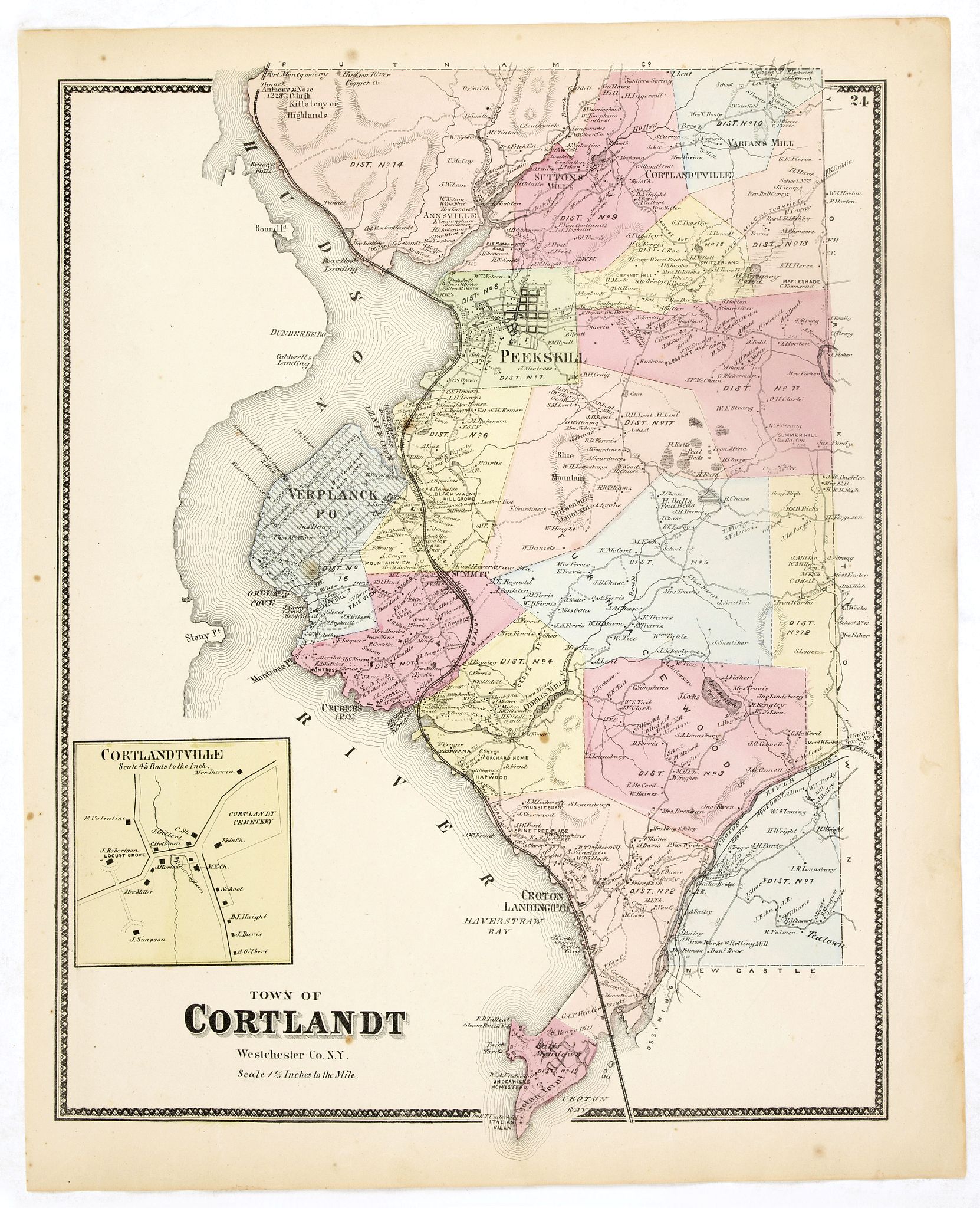
Town of Cortlandt.
BuyNow for $90
- Maker :
- DE BEERS, F.W.
- Place :
- New York
- Date :
- 1867
- Color :
- Original colors
- Height mm.:
- 405
- Width mm.:
- 320
- Condition :
- Some very light spotting but generally in very good condition.
- Bibliography :
- Barbara B. McCorkle 'The Strange Case of F.W. Beers and The Atlas of New York and Vicinity' in Meridian 5, pp.39-43. cf. Phillips 2290; cf. Rumsey 4631. Ristow, American Maps and Mapmakers, chapter 25.
- Seller's ref. :
- 37657
This item is offered by Paulus_Swaen_Old_Maps
See other Items from this seller- Postage
-
Europe
$35 to France
- Select Country
- Zip/Post Code
- Quantity
$90
Description
Fine lithographed map of the town of Cortlandt. The map provides the names of specific homeowners, as well as information about the occupations and physical locations of the various tradesmen in each village from Beer's famous county atlas "Atlas of New York and vicinity", "a documentary record of nineteenth-century life and delightful specimens of American folk art."
F. W. Beers, along with other members of his family, were among the leading county atlas publishers in the period immediately following the Civil War. Their atlases provide "a detailed cartographical, biographical, and pictorial record of a large segment of rural America in the Victorian age" (Ristow).
Beers first published his Atlas of New York & Vicinity in 1867.
Shows townships, roads, railroads, radial distances. "Atlas of New York and vicinity" published by Beers, Ellis & Soule, 95 Maiden Lane, New York.

Kaerte en Afbeeldinge vande Geheele Jurisdictie van Stantdarbuyten Gelegen in de Generaliteit onder Marquisaet van Bergen op den Zoom
With a large title cartouche with signature of the maker Adriaan van der Ende, : Kaerte en Afbeeldinge vande Geheele Jurisdictie van Stantdarbuyten Gelegen in de Generaliteit onder Marquisaet van Bergen op den Zoom, gemaekt, en in den Jare van 1733, 1734, 1735 gemeten by my ondergetz… Willemstadt den 8 Julij 1737 Adr: van Enden.Adriaan van de Ende was a surveyor, appointed by the Council of Brabant in 1720, then living in Heyningen. Was later living and active in Willemstad.Other manuscript m...
$2.500
Maker : VAN DE ENDEN, A.
Place : Willemstadt
Date : 1737

Beschrijvinge vande de zee Cuften va Vlanderen en Picardien. . .
DUTCH TEXT EDITION. A detailed chart of the coast of Flanders and Normandy decorated by a large colorful baroque title cartouche, and the coat of arms of Flanders with a colorful scale cartouche decorated with a compass, a compass rose, several vessels and sea monsters. From an early Dutch text edition of this landmark contribution to the science of navigation. Waghenaer's own personal experiences as a pilot along European coasts were used to compile the Spiegel der Zeevaerdt, the first edition ...
$3.000
Maker : WAGHENAER, L. J.
Place : Leiden, Plantijn
Date : 1585

Mappe-Monde pour connoitre les progres & les conquestes..
Unusual double hemisphere map with California as an Island. Dutch text describes the expeditions and colonial possessions of the Dutch East India Company. The map originated in about 1670. Chatelain acquired the plate; he added decorative elements, including sailing ships, the Dutch crest, and a figure representing Europa seated inside a native fort.Zacharie Chatelain (d.1723) was the father of Henri Abraham (1684-1743) and Zacharie Junior (1690-1754).They worked as a partnership publishing the ...
$800
Maker : CHATELAIN, H.
Place : Amsterdam
Date : 1729
![[Printed on silk] Nieuw Wassende Graaden Paskaart Vertoonende alle de bekende Zeekusten en Landen op den geheelen Aard Boodem of Werelt door Gerard van Keulen. . .](/uploads/cache/31640-500x500.jpg)
[Printed on silk] Nieuw Wassende Graaden Paskaart Vertoonende alle de bekende Zeekusten en Landen op den geheelen Aard Boodem of Werelt door Gerard van Keulen. . .
A very scarce and beautiful chart on Mercator's projection printed on silk. The map is printed on silk. With the name of Gerard van Keulen and the privilege. The map shows great interior detail, including a well-formed depiction of the Great Lakes and Mississippi River. Fort de Creveceur is shown near the Illinois River. The east coast of Siberia has been drawn after Nicolas Witsen's 1687 map of Tartary. A Great Companies Land has been added off the northwest coast of America. California is an i...
$20.000
Maker : VAN KEULEN, G.
Place : Amsterdam
Date : 1728
Postage & Shipping
-
Item Location
Terms and conditions - Item Location
- Amsterdam, , Netherlands
- Ships To
- United States, United Kingdom, Albania, Argentina, Armenia, Australia, Azerbaijan, Bahamas, Belgium, Bermuda, Cambodia, Canada, Chile, China, Croatia, Cyprus, Czech Republic, Denmark, Estonia, Finland, France, Germany, Gibraltar, Greece, Greenland, Guatemala, Hong Kong, Iceland, India, Indonesia, Israel, Italy, Japan, Latvia, Lithuania, Luxembourg, Malta, Mexico, Monaco, Netherlands, Norway, Singapore, Spain, Sweden, Switzerland, Turkey
- Pick-ups
- No pick-ups
This item is owned and offered by the seller Paulus_Swaen_Old_Maps - All items are available for immediate sale, offered subject to prior sale.
Invoices are created by the seller by using our shopping cart or be prepared by the seller the day following the order and are emailed to you.
Items offeres by different sellers are invoiced separately.
Shipping fees are extra. The buyer is responsible for all applicable taxes, including any VAT, customs clearance, import duties, or equivalent costs arriving at the customer's home border. Payment is due on receipt of the invoice. The item(s) are shipped as soon as possible after receipt of your payment.
Before buying please read the complete Terms Conditions of Sale.
- Payment Methods
- Visa, Mastercard, Bank Transfer, American Express, iDEAL, PayPal, Google Pay
- Returns Accepted
- No
Post Message
Feel free to ask the seller a question. Please note that the seller could be located in an area with a different time zone. Our seller will do their best to respond within 24 hours.Post your message below.
Sign in to ask the seller a question.
