ID: 474
Open

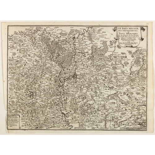
Le Païs Messin, ses dependances, et Terre Adiacentes.
BuyNow for €60
- Maker :
- DE FER, N.
- Place :
- Paris
- Date :
- 1705
- Color :
- Uncoloured
- Height mm.:
- 277
- Width mm.:
- 373
- Condition :
- Mint condition. Dark impression.
- Bibliography :
- -
- Seller's ref. :
- 40884
This item is offered by Librairie_Loeb-Larocque
See other Items from this seller- Postage
-
France
€15 to France
- Select Country
- Zip/Post Code
- Quantity
€60
Description
Map of the Messin region, from Nicolas de Fer's "L'Atlas curieux ou le Monde réprésente dans des cartes. "The "Atlas Curieux" is a geographic encyclopedia of images and a celebration of the French Empire under the Sun King, with maps of French possessions in the western hemisphere, maps of France, with detailed views of the grand waterworks at Marly, views of the great palaces and chateaux, views and plans of the Paris Observatory, and samples of military architecture. Issued in six annual parts from 1700-1705, the maps are based on the new observations of the Académie des Sciences, and drawn up with the assistance of Philipe de La Hire.
![Venetia. [Venice ]](/uploads/cache/45176-500x500.jpg)
Venetia. [Venice ]
Very rare view of Venice published in the first edition of "Viaggio da Venetia, a Costantinopoli. Per Mare, e per Terra, & infieme quello di Terra Santa. Da Gioseppe Rosaccio con brevita descritto".Several of the maps and plans resemble those in G. F. Camocio's "Isole famose", in particular the maps of the individual Greek islands, among which are Corfu, Crete, Cyprus, together with a map of Palestine and a view of Jerusalem.It is possible that many of the plates may originate from 1590-1597, wh...
€420
Maker : ROSACCIO, Giuseppe
Place : Venice, Giacomo Franco, 1598
Date : 1598
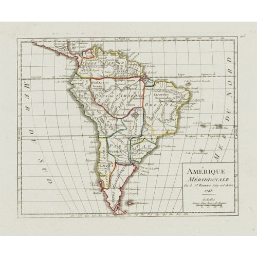
Amérique Méridionale.
Nice small map of South America. Dated 1748. From Atlas Portatif Universel, by Robert de Vaugondy.Page 105 outside border top right. Mary Sponberg Pedley does not mention a state without date.
€75
Maker : VAUGONDY, R. de
Place : Paris
Date : later than 1748
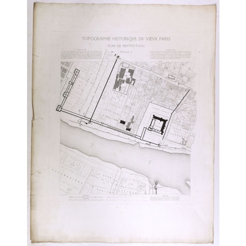
Topographie historique du vieux Paris / Plan de restitution Feuille V.
Copper engraved plan centered on Louvre by Jean-Joseph Sulpis (1826–1911) after a model by Adolphe Berty. Plate 5 from "Topographie historique du vieux Paris". The publication was started by Adolphe Berty and continued by H. Legrand and L.-M. Tisserand, Th. Vacquer and Camille Platon.
€75
Maker : BERTY, A.
Place : Paris
Date : 1866-1897
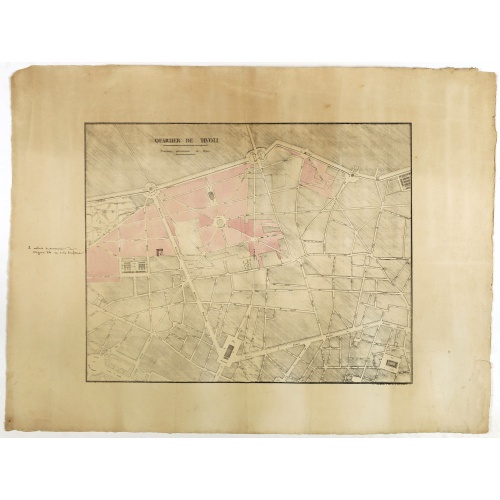
Quartier de Tivoli Nouveaux pereements de Rues.
Plan of the center of Paris showing Tivoli district with Madalene and Clichy. Lithography and pen and ink. Drawn in are the planned workshop of Serrurerie Théophile Mignon, 30 rue de la Bienfaisance.
€75
Maker : ANNONYMOUS
Place : Paris
Date : ca.1835
Postage & Shipping
-
Item Location
Terms and conditions - Item Location
- 75013, Ile-de-France, France
- Ships To
- United States, United Kingdom, Albania, Argentina, Armenia, Australia, Austria, Bahamas, Belgium, Bermuda, Bosnia and Herzegowina, Brazil, Bulgaria, Canada, Chile, China, Costa Rica, Denmark, Dominica, Egypt, El Salvador, Finland, France, Germany, Greece, Guatemala, Hong Kong, Hungary, Iceland, India, Italy, Japan, Korea (South), Kuwait, Liechtenstein, Lithuania, Luxembourg, Madagascar, Mexico, Monaco, Morocco, Netherlands, Netherlands Antilles, New Zealand, Norway, Paraguay, Peru, Philippines, Poland, Portugal, Qatar, Reunion, Romania, San Marino, Saudi Arabia, Seychelles, Singapore, Slovenia, South Africa, Spain, Sri Lanka, Suriname, Sweden, Switzerland, Taiwan, Thailand, Tunisia, Turkey, United Arab Emirates, Uruguay, Vietnam
- Pick-ups
- Buyer can pick-up
This item is owned and offered by the seller Librairie_Loeb-Larocque - All items are available for immediate sale, offered subject to prior sale.
Invoices are created by the seller by using our shopping cart or be prepared by the seller the day following the order and are emailed to you.
Items offeres by different sellers are invoiced separately.
Shipping fees are extra. The buyer is responsible for all applicable taxes, including any VAT, customs clearance, import duties, or equivalent costs arriving at the customer's home border. Payment is due on receipt of the invoice. The item(s) are shipped as soon as possible after receipt of your payment.
Before buying please read the complete Terms Conditions of Sale.
- Payment Methods
- Visa, Mastercard, Bank Transfer, American Express, iDEAL, PayPal, Google Pay
- Returns Accepted
- No
Post Message
Feel free to ask the seller a question. Please note that the seller could be located in an area with a different time zone. Our seller will do their best to respond within 24 hours.Post your message below.
Sign in to ask the seller a question.