ID: 209
Open
Listing ID: #209 has been added to your wishlist.
![Venetia. [Venice ]](/uploads/45176.jpg)
Venetia. [Venice ]
BuyNow for €420
- Maker :
- ROSACCIO, Giuseppe
- Place :
- Venice, Giacomo Franco, 1598
- Date :
- 1598
- Color :
- Uncolored
- Height mm.:
- 100
- Width mm.:
- 180
- Condition :
- Paper age-toned, slightly water staining in lower right and in upper part, brown staining in left part. A few brown spotting. Margins a little bit frayed.
- Bibliography :
- -
- Seller's ref. :
- 45176
This item is offered by Librairie_Loeb-Larocque
See other Items from this seller- Postage
-
France
€15 to France
- Select Country
- Zip/Post Code
- Quantity
€420
Description
Very rare view of Venice published in the first edition of "Viaggio da Venetia, a Costantinopoli. Per Mare, e per Terra, & infieme quello di Terra Santa. Da Gioseppe Rosaccio con brevita descritto".
Several of the maps and plans resemble those in G. F. Camocio's "Isole famose", in particular the maps of the individual Greek islands, among which are Corfu, Crete, Cyprus, together with a map of Palestine and a view of Jerusalem.
It is possible that many of the plates may originate from 1590-1597, when they seem to have appeared first in a little-known work "Raccolta da disegni di tutte le citta et fortezze di mare che sono nel viaggio a Costantinopoli" [Venice (1597?)]. They were probably engraved by Natale Bonifacio.
Rosaccio (c.1530-1620) produced many small format atlases and geographical works, as well as works on astrology and astronomy.
![[Les anciennes provinces Françaises à la ville de Saint Denis].](/uploads/cache/41681-500x500.jpg)
[Les anciennes provinces Françaises à la ville de Saint Denis].
Nine small chromolithography's trade cards for Ville de Saint Denis, each with French regions and places, with description in French on each verso.Cards of the regions : Bretagne, L'Angoumois, Ile de France, Anjou, Limousin, Picardie, Provence, Savoie, Poitou.
€80
Maker : H. LAAS / PECAUD / CIE PARIS
Place : Paris
Date : ca. 1900
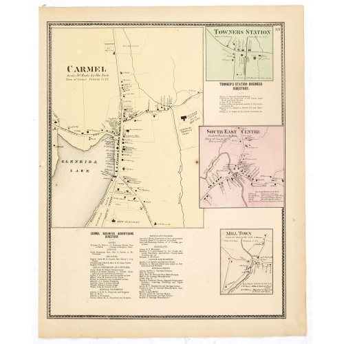
Town of Carmel / Towners Station / South East Centre / Mill Town.
Fine lithographed map of the town of Carmel / Towners Station / South East Centre / Mill Town. From "Atlas of New York and vicinity" published by Beers, Ellis & Soule, 95 Maiden Lane, New York.The map provides the names of specific homeowners, as well as information about the occupations and physical locations of the various tradesmen in each village from Beer's famous county atlas "Atlas of New York and vicinity," "a documentary record of nineteenth-century life and delightful specimens of Ame...
€80
Maker : DE BEERS, F. W.
Place : New York
Date : 1867
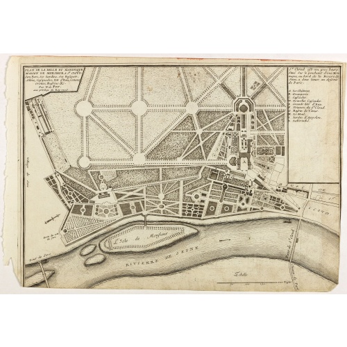
Plan de la belle et magnifique Maison de Monsieur A St Cloud . . .
Plan of the city of Saint Cloud, from Nicolas de Fer's "L'Atlas curieux ou le Monde réprésente dans des cartes. "The "Atlas Curieux" is a geographic encyclopedia of images and a celebration of the French Empire under the Sun King, with maps of French possessions in the western hemisphere, maps of France, with detailed views of the grand waterworks at Marly, views of the great palaces and chateaux, views and plans of the Paris Observatory, and samples of military architecture. Issued in six ann...
€60
Maker : DE FER, N.
Place : Paris
Date : 1705
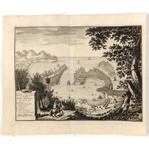
Haven van Aquapulco in ' Coninkryk van Nova Spagnien in de Zuyd Zee.
A finely engraved plan of the harbor, fort and village of Acapulco drawn from a hilltop vantage point looking out to sea. Several galleons are pictured approaching or anchored in the harbor. After Johannes Vingboons.François Valentijn (1666-1727), a missionary, worked at Amboina from 1684 to 1694 and 1705 to 1713 and traveled extensively in the VOC's lands. He is best known for his monumental history and description, "Oud en Nieuw Oost-Indiën" which remains one of the most important primary so...
€650
Maker : VALENTIJN, F.
Place : Amsterdam
Date : 1726
Postage & Shipping
-
Item Location
Terms and conditions - Item Location
- 75013, Ile-de-France, France
- Ships To
- United States, United Kingdom, Albania, Argentina, Armenia, Australia, Austria, Bahamas, Belgium, Bermuda, Bosnia and Herzegowina, Brazil, Bulgaria, Canada, Chile, China, Costa Rica, Denmark, Dominica, Egypt, El Salvador, Finland, France, Germany, Greece, Guatemala, Hong Kong, Hungary, Iceland, India, Italy, Japan, Korea (South), Kuwait, Liechtenstein, Lithuania, Luxembourg, Madagascar, Mexico, Monaco, Morocco, Netherlands, Netherlands Antilles, New Zealand, Norway, Paraguay, Peru, Philippines, Poland, Portugal, Qatar, Reunion, Romania, San Marino, Saudi Arabia, Seychelles, Singapore, Slovenia, South Africa, Spain, Sri Lanka, Suriname, Sweden, Switzerland, Taiwan, Thailand, Tunisia, Turkey, United Arab Emirates, Uruguay, Vietnam
- Pick-ups
- Buyer can pick-up
This item is owned and offered by the seller Librairie_Loeb-Larocque - All items are available for immediate sale, offered subject to prior sale.
Invoices are created by the seller by using our shopping cart or be prepared by the seller the day following the order and are emailed to you.
Items offeres by different sellers are invoiced separately.
Shipping fees are extra. The buyer is responsible for all applicable taxes, including any VAT, customs clearance, import duties, or equivalent costs arriving at the customer's home border. Payment is due on receipt of the invoice. The item(s) are shipped as soon as possible after receipt of your payment.
Before buying please read the complete Terms Conditions of Sale.
- Payment Methods
- Visa, Mastercard, Bank Transfer, American Express, iDEAL, PayPal, Google Pay
- Returns Accepted
- Yes
- Returns Policy
- Please contact us for instructions before returning items.
Post Message
Feel free to ask the seller a question. Please note that the seller could be located in an area with a different time zone. Our seller will do their best to respond within 24 hours.Post your message below.
Sign in to ask the seller a question.
![Venetia. [Venice ]](/uploads/cache/45176-500x500.jpg)
-500x500.jpg)