
ID: 245
Open
Listing ID: #245 has been added to your wishlist.
.jpg)
Peru.
BuyNow for $900
- Maker :
- BLAEU, W.
- Place :
- Amsterdam
- Date :
- 1644
- Color :
- Original colors
- Height mm.:
- 375
- Width mm.:
- 490
- Condition :
- Very good condition, with a dark impression. French text on verso.
- Bibliography :
- V.d.Krogt, Atlantes Neerlandici.
- Seller's ref. :
- 45265
This item is offered by Paulus_Swaen_Old_Maps
See other Items from this seller- Postage
-
Europe
$34 to France
- Select Country
- Zip/Post Code
- Quantity
$900
Description
FIRST EDITION, FIRST ISSUE OF THIS MAP. Decorated with ships and monsters in the sea. Orientated with east at the top. With the signature of G. Blaeuw lower right corner. Shows the Pacific coast of South America from Ecuador (at the left-hand side) as far south as the Atacama desert in the northern reaches of Chile."As early as 1520, Spanish settlers in Panama had heard tales of a powerful civilization rich in gold that lay to the south, and in 1522 an expedition was organized to find this land and the people called Birú or Pirú in the south.
In 1524 Francisco Pizarro led the first of his expeditions that led ultimately to the discovery and conquest of the Inca empire which extended over wide areas of modern Ecuador, Peru, Bolivia and part of Chile.
Pizarro obtained from Atahuallpa, the head of the Inca empire, a huge ransom of silver and gold that made Spain rich almost beyond the most inventive dreams of the Spanish conquerors, and once the mountain city of Cuzco was captured in 1533, the Spanish hold over much of South America was virtually complete." (John Goss)
From early on Willem Jansz. Blaeu aimed of publishing an atlas to compete with the Hondius-Jansson Atlas. By 1630, he had published at least 17 folio size maps. Blaeu was able to realize his plan soon after he had acquired the copper plates of the atlas maps by Jodocus Hondius. The "Appendix followed in 1630.
In 1635 he finally realized a "international edition" of a world atlas, the "Theatrum Orbis Terrarum".

Nieuwe Wassende Graade Zee Kaart over de Spaanse Zee Vant Kanaal tot 't Eyland Cuba in Westindia. . .
¤ Engraved by I.van Anse. A very representative example of a Dutch chart of the Atlantic, showing the north-east coast of America, the coasts of Africa and Europe and South America, including Florida and the West Indies. Gerard issued ca. 40 charts of this exceptionally large format. Collections of these large-size charts were issued in the shining sea-torch and as separate atlases.Title in Dutch, French and English. North America from Labrador to West Florida, including New Foundland, the Gulf...
$3.000
Maker : VAN KEULEN, G.
Place : Amsterdam
Date : 1728
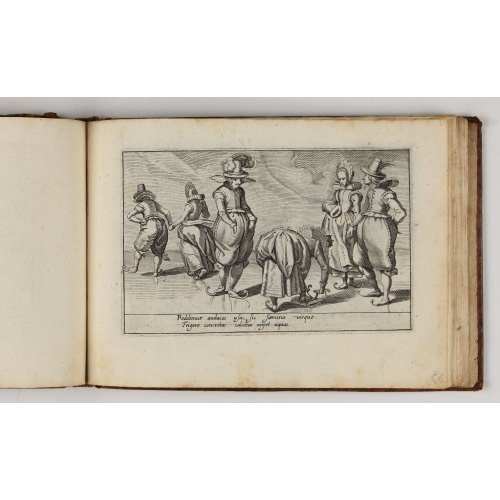
Deliciae Batavicae.
It is a charming book illustrated with portraits of Willem of Orange and Prince Maurits and eight engraved armorial plates. Followed by thirthy engraved views or scenes of Dutch cities, most with Latin text at the foot.The plates include views of Amsterdam, Leiden, a skating scene, and Prince Maurits sailing wagon. The Anatomy Theatre of the University of Leiden with a finely attired man looking at the dissected body of a man lying on the central table, surrounded by concentric benches with hum...
$5.000
Maker : MARCUS, J.
Place : Amsterdam, Johannes Janssonius
Date : 1618
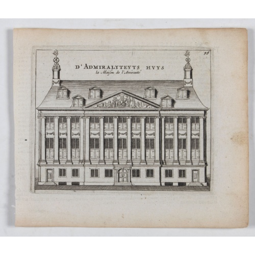
D' Admiralyteyts Huys - La maison de l'Amirauté.
Decorative print of the "D'Admiralyteits Huys", Het Prinsenhof, of the Dutch East India Company VOC. Located at the Oudezijds Voorburgwal 195-199, Amsterdam.
$150
Maker : ANONYMOUS
Place : Amsterdam
Date : ca. 1700
-500x500.jpg)
Holland & Belgium.
An attractive steel engraved map of Holland and Belgium. Map flanked by France and Prussia. Duchy of Luxembourg included. Many place names and physical features shown. 4 mileage scales given.The Arrowsmith family members were among the most respected and influential cartographers of the nineteenth century. Taken from 'The London Atlas of Universal Geography…' John Arrowsmith (1790-1873) joined his uncle, Aaron Arrowsmith in mapmaking in London in 1810. Upon the death of his uncle in 1823, the ...
$110
Maker : ARROWSMITH, John
Place : London, 1839
Date : 1839
Postage & Shipping
-
Item Location
Terms and conditions - Item Location
- 75013, Ile-de-France, France
- Ships To
- United States, United Kingdom, Albania, Argentina, Armenia, Australia, Azerbaijan, Bahamas, Belgium, Bermuda, Cambodia, Canada, Chile, China, Croatia, Cyprus, Czech Republic, Denmark, Estonia, Finland, France, Germany, Gibraltar, Greece, Greenland, Guatemala, Hong Kong, Iceland, India, Indonesia, Israel, Italy, Japan, Latvia, Lithuania, Luxembourg, Malta, Mexico, Monaco, Netherlands, Norway, Singapore, Spain, Sweden, Switzerland, Turkey
- Pick-ups
- No pick-ups
This item is owned and offered by the seller Paulus_Swaen_Old_Maps - All items are available for immediate sale, offered subject to prior sale.
Invoices are created by the seller by using our shopping cart or be prepared by the seller the day following the order and are emailed to you.
Items offeres by different sellers are invoiced separately.
Shipping fees are extra. The buyer is responsible for all applicable taxes, including any VAT, customs clearance, import duties, or equivalent costs arriving at the customer's home border. Payment is due on receipt of the invoice. The item(s) are shipped as soon as possible after receipt of your payment.
Before buying please read the complete Terms Conditions of Sale.
- Payment Methods
- Visa, Mastercard, Bank Transfer, American Express, iDEAL, PayPal, Google Pay
- Returns Accepted
- No
Post Message
Feel free to ask the seller a question. Please note that the seller could be located in an area with a different time zone. Our seller will do their best to respond within 24 hours.Post your message below.
Sign in to ask the seller a question.
-500x500.jpg)
![[A prisoner of the Indians of Tupinamba, covered in feathers . . .]](/uploads/cache/41101-500x500.jpg)
![[How natives of Paria cope with illness] / Vespucci reaches Lake Maracaibo]..](/uploads/cache/41095-(2)-500x500.jpg)