
ID: 309
Open
.jpg)
Town of Verplanck / Crugers / Croton Landing.
BuyNow for $90
- Maker :
- DE BEERS, F.W.
- Place :
- New York
- Date :
- 1867
- Color :
- Original colors
- Height mm.:
- 405
- Width mm.:
- 320
- Condition :
- Some very light spotting but generally in very good condition.
- Bibliography :
- Barbara B. McCorkle 'The Strange Case of F.W. Beers and The Atlas of New York and Vicinity' in Meridian 5, pp.39-43. cf. Phillips 2290; cf. Rumsey 4631. Ristow, American Maps and Mapmakers, chapter 25.
- Seller's ref. :
- 37658
This item is offered by Paulus_Swaen_Old_Maps
See other Items from this seller- Postage
-
Europe
$34 to France
- Select Country
- Zip/Post Code
- Quantity
$90
Description
Fine lithographed map of the town of Verplanck / Crugers / Croton Landing. The map provides the names of specific homeowners, as well as information about the occupations and physical locations of the various tradesmen in each village from Beer's famous county atlas "Atlas of New York and vicinity," "a documentary record of nineteenth-century life and delightful specimens of American folk art."
F. W. Beers, along with other members of his family, were among the leading county atlas publishers in the period immediately following the Civil War. Their atlases provide "a detailed cartographical, biographical, and pictorial record of a large segment of rural America in the Victorian age" (Ristow).
Beers first published his Atlas of New York & Vicinity in 1867.
Shows townships, roads, railroads, radial distances. "Atlas of New York and vicinity" published by Beers, Ellis & Soule, 95 Maiden Lane, New York.
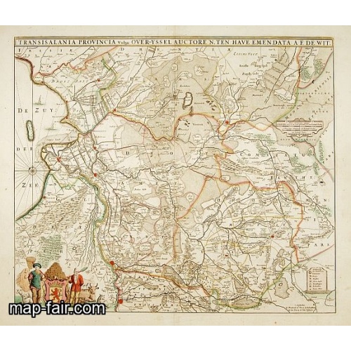
Transisalania provincia vulgo Over-Yssel auctore N.ten Have
Detailed map prepared by Nico ten Have.
$300
Maker : DE WIT, F.
Place : Amsterdam
Date : 1690

Freedom of the Air.
A world map packed with information about aviation and the aluminum industry.The use of aircraft in warfare, especially in the roles of close ground support and strategic bombing, was completely revolutionized during WWII. Apart from tactics, the technology also evolved to facilitate heavier bombers, faster fighters, more capable transports and greater range all-around. One critical component of this development was using light, flexible and sturdy aluminum frames and skins for the planes, rathe...
$230
Maker : ALCOA ALUMINUM COMPANY.
Place : United-States
Date : 1943
-500x500.jpg)
Virulus marinus. Cete (Whale and whaling scene)
Whale and whaling scene, set against a mountainous landscape in the manner of Pieter Brueghel the Elder. Plate number 1. The engraving is copied after Adrian Collaert plate in "Piscium Vivæ Icones" a series first published in Antwerp by Adriaen Collaert after 1598, later published between 1627 and 1677 by Galle family. Several copies were made of this series.Most of the ships in the background were copied from a series of ten prints known as the Sailing Vessels, executed by Frans Huys after des...
$300
Maker : COLLAERT, Adriaen (after)
Place : Antwerp
Date : after 1598

Eastern passage to China. sheet 1.
James Horsburgh early chart of the coasts of Java, Bali, Lombok, with part of Sulawesi, and Borneo. Insets of "Sketch of Bally Strait", Sketch of Lombock Strait", Plan of Allas Strait", "Sketch of Sappy Strait".The chart shows depth soundings & both topographical and hydrographical details and proposed sailing directions in the Sunda Straits. Filled with several coastal profiles, which were of great help for the sailor.In top Horsburgh thanks for the aid he has gotten for preparing this chart : ...
$3.000
Maker : HORSBURGH, JAMES, F.R.S
Place : London
Date : 1824
Postage & Shipping
-
Item Location
Terms and conditions - Item Location
- Amsterdam, , Netherlands
- Ships To
- United States, United Kingdom, Albania, Argentina, Armenia, Australia, Azerbaijan, Bahamas, Belgium, Bermuda, Cambodia, Canada, Chile, China, Croatia, Cyprus, Czech Republic, Denmark, Estonia, Finland, France, Germany, Gibraltar, Greece, Greenland, Guatemala, Hong Kong, Iceland, India, Indonesia, Israel, Italy, Japan, Latvia, Lithuania, Luxembourg, Malta, Mexico, Monaco, Netherlands, Norway, Singapore, Spain, Sweden, Switzerland, Turkey
- Pick-ups
- No pick-ups
This item is owned and offered by the seller Paulus_Swaen_Old_Maps - All items are available for immediate sale, offered subject to prior sale.
Invoices are created by the seller by using our shopping cart or be prepared by the seller the day following the order and are emailed to you.
Items offeres by different sellers are invoiced separately.
Shipping fees are extra. The buyer is responsible for all applicable taxes, including any VAT, customs clearance, import duties, or equivalent costs arriving at the customer's home border. Payment is due on receipt of the invoice. The item(s) are shipped as soon as possible after receipt of your payment.
Before buying please read the complete Terms Conditions of Sale.
- Payment Methods
- Visa, Mastercard, Bank Transfer, American Express, iDEAL, PayPal, Google Pay
- Returns Accepted
- No
Post Message
Feel free to ask the seller a question. Please note that the seller could be located in an area with a different time zone. Our seller will do their best to respond within 24 hours.Post your message below.
Sign in to ask the seller a question.
-500x500.jpg)
