ID: 107
Open
Listing ID: #107 has been added to your wishlist.
Freedom of the Air.
BuyNow for $230
- Maker :
- ALCOA ALUMINUM COMPANY.
- Place :
- United-States
- Date :
- 1943
- Color :
- Printed colors
- Height mm.:
- 850
- Width mm.:
- 605
- Condition :
- Offset. Creasing along fold lines, some of which have small tears along the folds that have been repaired on the verso. Very good overall, with bright colors lithographed on a clean sheet.
- Bibliography :
- -
- Seller's ref. :
- 47149
This item is offered by Paulus_Swaen_Old_Maps
See other Items from this seller- Postage
-
Europe
$34 to Netherlands
- Select Country
- Zip/Post Code
- Quantity
$230
Description
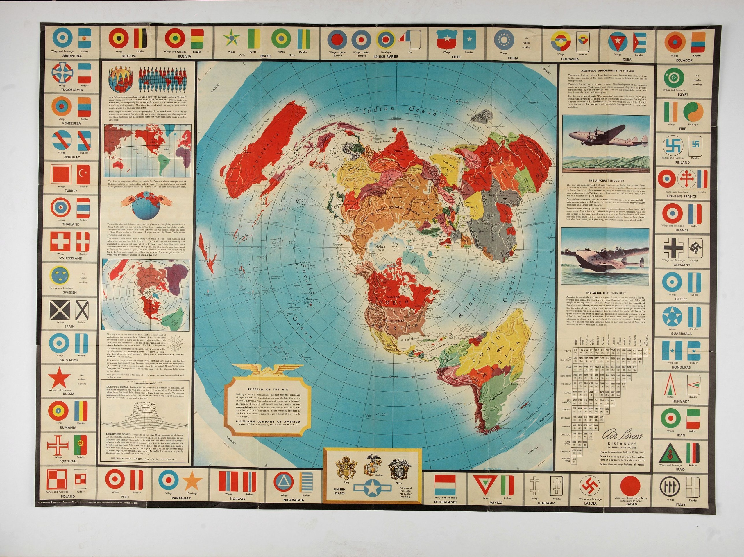
A world map packed with information about aviation and the aluminum industry.The use of aircraft in warfare, especially in the roles of close ground support and strategic bombing, was completely revolutionized during WWII. Apart from tactics, the technology also evolved to facilitate heavier bombers, faster fighters, more capable transports and greater range all-around.
One critical component of this development was using light, flexible and sturdy aluminum frames and skins for the planes, rather than the wood and canvas popularized during WWI.
Alcoa, a major American aluminum manufacturer, was well poised to capitalize on these wartime developments and issued this map to educate the American public about the company’s role in the conflict.
The main image is a world map on a polar projection (or Azimuthal Equidistant, if you want to get technical) which highlights the shortened distances between locations on the globe via air.
The explanatory text regarding the map’s projection and the benefits of aluminum can be found on either side of the map, while the border is comprised of the wing, rudder and tail markings of aircraft from major countries around the world. Interestingly, the belligerent status (Allied, Axis, Neutral) seems to play no part in the selection of the countries depicted. Neutral Spain, “Fighting France,” the Chinese Nationalists, occupied Poland and “Eire” (Ireland) are all shown.
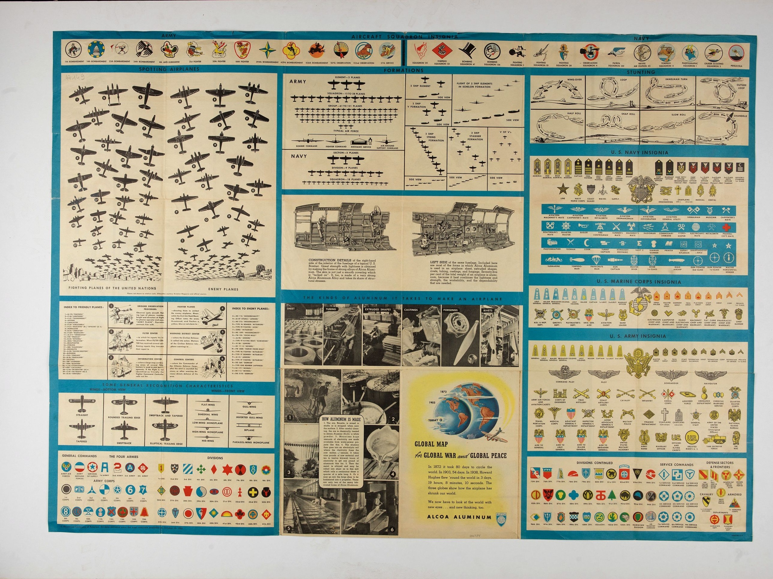
Aviation information continues on the verso of the sheet, which contains numerous charts and diagrams of military insignia, unit logos, profiles of Allied and Axis aircraft, the organizational structure of air corps, and even illustrations of specific dogfighting techniques.
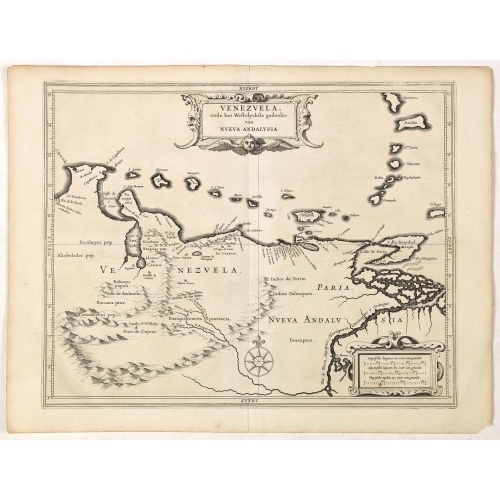
Venezuela, atque Occidentalis Pars Novæ Andalusiae.
Coastline of Venezuela with little interior development. Including Aruba, Bonaire, Curaçao, etc. Scarce map prepared by Hessel Gerritsz (1581-1632), former apprentice of Willem Blaeu, and Blaeu’s predecessor as chief cartographer of the Dutch East India Company. Gerritsz enjoys a very high reputation for his critical approach towards his sources.Most of Gerritsz’ work exists only in manuscript, and these maps published by de Laet, are among the only printed Gerritsz maps available to the co...
$600
Maker : LAET, DE J. / GERITSZ, H.
Place : Leiden, Elzevier
Date : 1630
![Groeninga MDLXXIII. [Groningen]](/uploads/cache/27192-500x500.jpg)
Groeninga MDLXXIII. [Groningen]
RECTO: A panoramic view of the city of Groningen dated 1573.VERSO: a woodcut of a cow, a bull and their calf.Taken from Sebastian Munster's encyclopedic work, the "Cosmographia Universalis". The Cosmographia by Sebastian Münster had numerous editions in different languages including Latin, French (translated by François de Belleforest), Italian, English, and even Czech. The last German edition was published in 1628, long after his death. The Cosmographia was one of the most successful and popu...
$60
Maker : MUNSTER, S.
Place : Basle, ca. 1564
Date : 1564
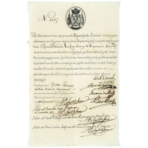
Very rare share in the Ostend Company. (4527)
Upper left hand corner share number 4527 in manuscript. In top emblem of the Ostend Company in copper engraving. Text: De Directeurs van de generale Keijserlijche- Indische compagnie, ordoneren aen hunnen cassier 'joan Baptist Cogels junior, te ontvangen van D'Heer Ferdinand Anthoin Baron de Veecquemans, Antwerp. de somme van tweehondert en vijftigh guldens wisselgeldt, voor het eerste payement sijnder actie van een duijsent guldens in het Capitael van de Selve compagnie, op de conditien in het ...
$2.000
Maker : OSTEND COMPANY
Place : Antwerp / Ostend
Date : 1723
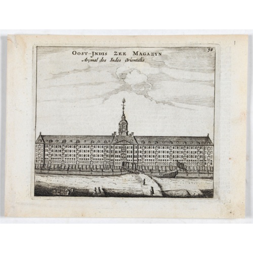
Oost-Indis Zee Magazyn - Arçenal des Indes Orientalis.
Decorative view of the East Indian Arsenal, now-a-says the Maritime Museum.
$150
Maker : ANONYMOUS
Place : Amsterdam
Date : ca. 1700
Postage & Shipping
-
Item Location
Terms and conditions - Item Location
- 75013, Ile-de-France, France
- Ships To
- United States, United Kingdom, Albania, Argentina, Armenia, Australia, Azerbaijan, Bahamas, Belgium, Bermuda, Cambodia, Canada, Chile, China, Croatia, Cyprus, Czech Republic, Denmark, Estonia, Finland, France, Germany, Gibraltar, Greece, Greenland, Guatemala, Hong Kong, Iceland, India, Indonesia, Israel, Italy, Japan, Latvia, Lithuania, Luxembourg, Malta, Mexico, Monaco, Netherlands, Norway, Singapore, Spain, Sweden, Switzerland, Turkey
- Pick-ups
- No pick-ups
This item is owned and offered by the seller Paulus_Swaen_Old_Maps - All items are available for immediate sale, offered subject to prior sale.
Invoices are created by the seller by using our shopping cart or be prepared by the seller the day following the order and are emailed to you.
Items offeres by different sellers are invoiced separately.
Shipping fees are extra. The buyer is responsible for all applicable taxes, including any VAT, customs clearance, import duties, or equivalent costs arriving at the customer's home border. Payment is due on receipt of the invoice. The item(s) are shipped as soon as possible after receipt of your payment.
Before buying please read the complete Terms Conditions of Sale.
- Payment Methods
- Visa, Mastercard, Bank Transfer, American Express, iDEAL, PayPal, Google Pay
- Returns Accepted
- No
Post Message
Feel free to ask the seller a question. Please note that the seller could be located in an area with a different time zone. Our seller will do their best to respond within 24 hours.Post your message below.
Sign in to ask the seller a question.