ID: 328
Open
Listing ID: #328 has been added to your wishlist.
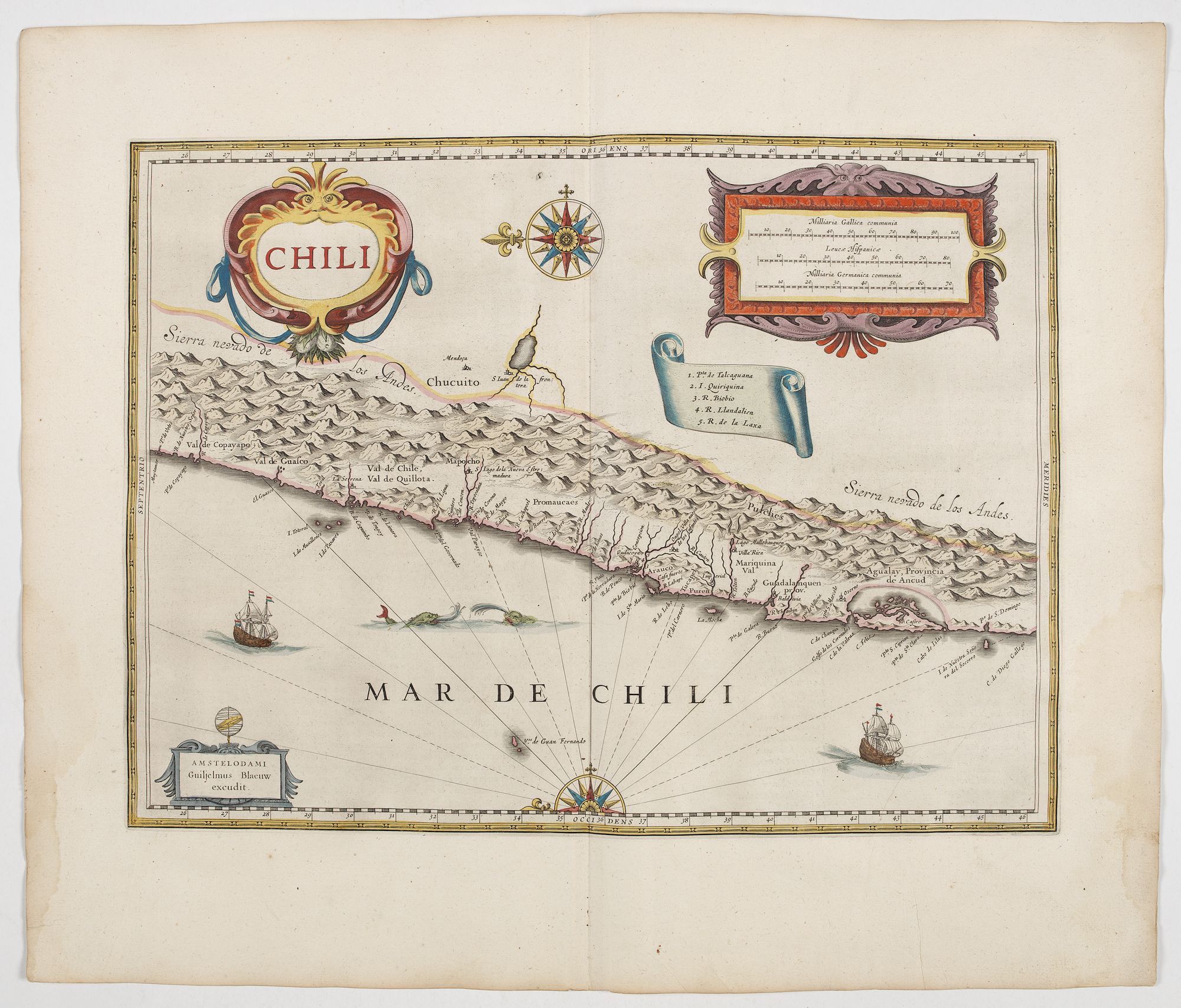
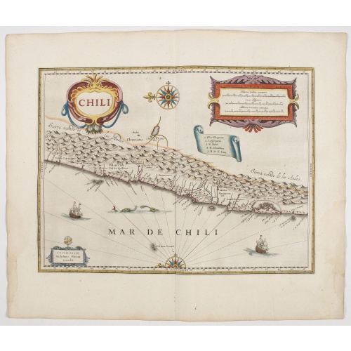
Chili.
BuyNow for $900
- Maker :
- BLAEU, W.
- Place :
- Amsterdam, 1644
- Date :
- 1644
- Color :
- Original colors
- Height mm.:
- 355
- Width mm.:
- 480
- Condition :
- A dark impression. French text on verso. In very fine condition.
- Bibliography :
- -
- Seller's ref. :
- 45175
This item is offered by Paulus_Swaen_Old_Maps
See other Items from this seller- Postage
-
Europe
$34 to France
- Select Country
- Zip/Post Code
- Quantity
$900
Description
Willem Blaeu's very decorative map of Chili with two large and beautiful cartouches, a compass and ships.From early on Willem Jansz. Blaeu aimed of publishing an atlas to compete with the Hondius-Janssonius Atlas. By 1630, he had published at least 17 folio size maps.
Blaeu was able to realize his plan soon after he had acquired the copper plates of the atlas maps by Jodocus Hondius. The "Appendix followed in 1630.
In 1635 he finally realized a "international edition" of a world atlas, the "Theatrum Orbis Terrarum".
-500x500.jpg)
Amstelodamum, Celebre Emporium Forma Plana.
Second state of this rare and decorative plan of Amsterdam with Visscher's imprint. With a panoramic view seen from the IJ and further insets of Council House, The Exchange, House of the Dutch East India Company and House of the West India Company. This state figures the fourth extension with the projected growth of the city added to the left half of the sheet; on the west side, the "Realeneiland" has been extended, above the image of the west India House, the imprint of Visscher has been added,...
$5.000
Maker : VISSCHER, Claes Jansz.
Place : Amsterdam
Date : c. 1636
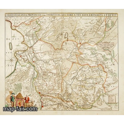
Transisalania provincia vulgo Over-Yssel auctore N.ten Have
Detailed map prepared by Nico ten Have.
$300
Maker : DE WIT, F.
Place : Amsterdam
Date : 1690
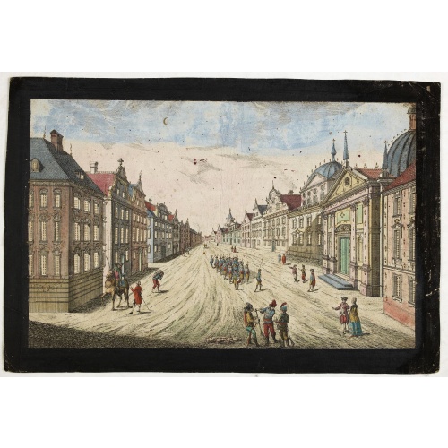
Prospect des Haupt Plazes der Untern Stadt zu Quebec.
A so-called optical print showing a decorative imaginary town view of Québec, with a street view with soldiers marching and pedestrians, an idealized view depicting Québec as a typical European city.By Franz Xavier Habermann (1721-1796).This print is a fine example of this illusionary printmaking, but also as a testament to the strong interest by Europeans in America at the time and also as a fine example of the perspective view.In the eighteenth and nineteenth centuries, there were many popul...
$500
Maker : ACADEMIE
Place : Augsburg, ca.1780
Date : 1780
![[Diego de Almagro is killed.]](/uploads/cache/40354-500x500.jpg)
[Diego de Almagro is killed.]
Almagro returned to Cuzco, disillusioned and embittered from his long and fruitless journey south into Chile, where he had been searching for further wealth. This led to a split in the control of Peru between the Pizarrists, who held the coastal regions, and the Almagrists who held the Cordillera. Further quarreling culminated in a battle just outside Cuzco in 1538, known as Las Salinas, which the Pizarrists eventually won. Almagro was subsequently garrotted and his captain, Orgóñez, beheaded....
$80
Maker : GOTTFRIED, J.L. / DE BRY.
Place : Frankfurt, M.Merian
Date : 1633
Postage & Shipping
-
Item Location
Terms and conditions - Item Location
- 75013, Ile-de-France, France
- Ships To
- United States, United Kingdom, Albania, Argentina, Armenia, Australia, Azerbaijan, Bahamas, Belgium, Bermuda, Cambodia, Canada, Chile, China, Croatia, Cyprus, Czech Republic, Denmark, Estonia, Finland, France, Germany, Gibraltar, Greece, Greenland, Guatemala, Hong Kong, Iceland, India, Indonesia, Israel, Italy, Japan, Latvia, Lithuania, Luxembourg, Malta, Mexico, Monaco, Netherlands, Norway, Singapore, Spain, Sweden, Switzerland, Turkey
- Pick-ups
- No pick-ups
This item is owned and offered by the seller Paulus_Swaen_Old_Maps - All items are available for immediate sale, offered subject to prior sale.
Invoices are created by the seller by using our shopping cart or be prepared by the seller the day following the order and are emailed to you.
Items offeres by different sellers are invoiced separately.
Shipping fees are extra. The buyer is responsible for all applicable taxes, including any VAT, customs clearance, import duties, or equivalent costs arriving at the customer's home border. Payment is due on receipt of the invoice. The item(s) are shipped as soon as possible after receipt of your payment.
Before buying please read the complete Terms Conditions of Sale.
- Payment Methods
- Visa, Mastercard, Bank Transfer, American Express, iDEAL, PayPal, Google Pay
- Returns Accepted
- No
Post Message
Feel free to ask the seller a question. Please note that the seller could be located in an area with a different time zone. Our seller will do their best to respond within 24 hours.Post your message below.
Sign in to ask the seller a question.