
ID: 76
Closed
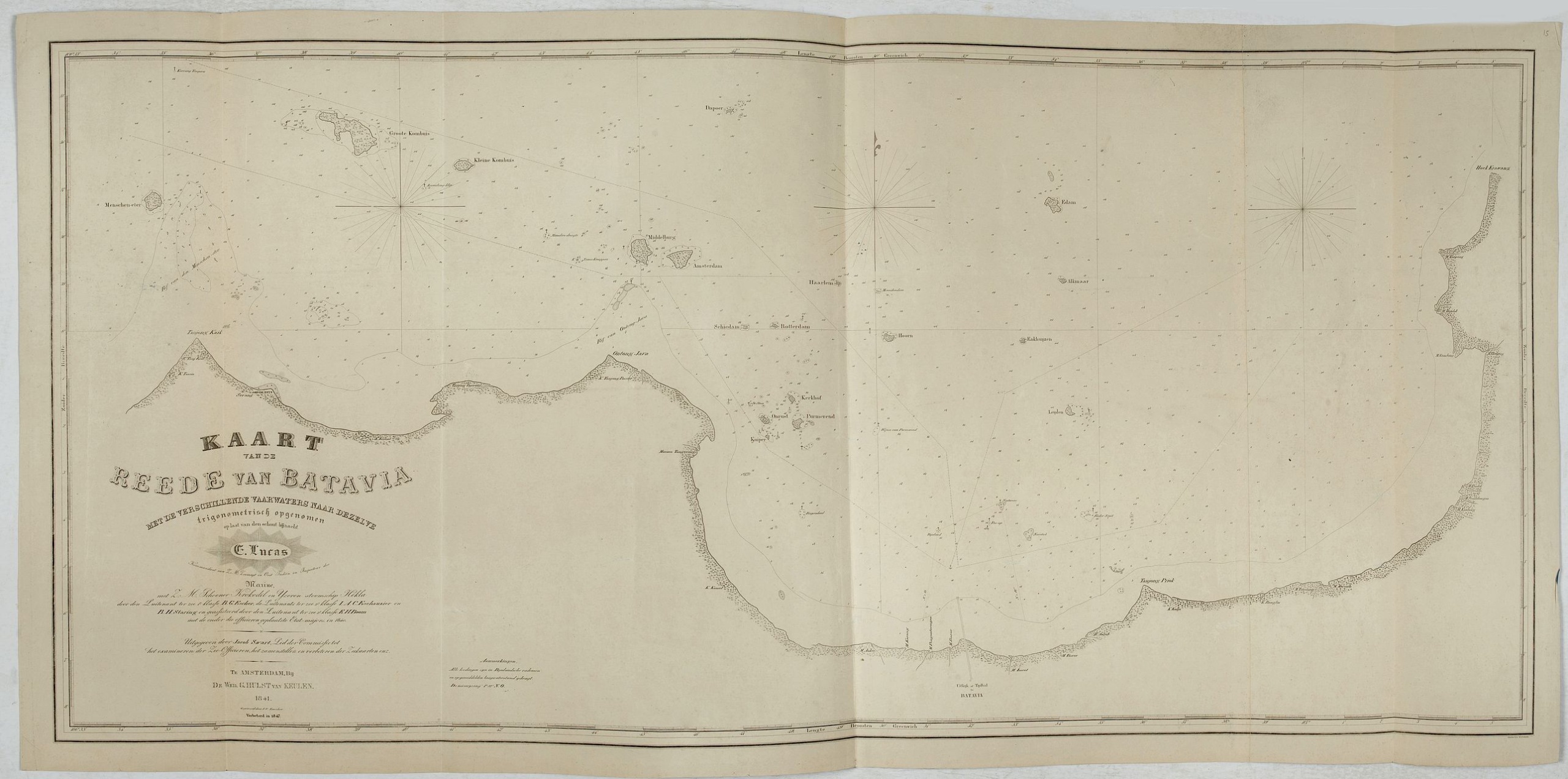
Kaart van de Reede van Batavia met de verschillende vaarwaters naar dezelve trigometrisch opgenomen op last van deb schout bijnacht E.Lucas.
BuyNow for $1.800
- Maker :
- HULST VAN KEULEN, Wed. G.
- Place :
- Amsterdam
- Date :
- (1841) 1847
- Color :
- Uncoloured
- Height mm.:
- 540
- Width mm.:
- 1228
- Condition :
- 2 sheets joined and laid down on a sheet of blue paper. Good impression. Slight age toning of paper. Various vertical folds as issued. Altogether very good condition.
- Bibliography :
- -
- Seller's ref. :
- 23244
This item is offered by Paulus_Swaen_Old_Maps
See other Items from this seller- Postage
-
Standard Shipping
$0 to Netherlands
- Select Country
- Zip/Post Code
- Quantity
$1.800
Description
Very large and rare so-called blue-black chart centered on Jakarta's harbor.
When Gerard Hulst van Keulen died in 1801, his widow ran the firm until her death in 1810, at which time Johannes Hulst van Keulen became the last van Keulen to run the firm.
In 1823, Jacob Swart entered the service of the van Keulen firm, and in 1844, with the death of Johannes Hulst van Keulen, head of the van Keulen Chartmakers was passed to Jacob Swart. When Jacob died in 1866, he was succeeded by his son, Jacob Swart, Jr.
Finally, the possessions of the firm were sold at auction in 1885.

Inventio Maris Magallanici.
Allegorical scene allegorical image celebrating the circumnavigation of the earth by Ferdinand Magellan. The image shows Magellan on board of his ship, surrounded by mythological figures including Apollo with sun and lyre, Zeus on his throne of clouds, Adam and Eve. A bird carrying an elephant and a depiction of the Tierra del Fuego.The image also includes cannon, banner with the double-headed Hapsburg eagle, anchor, broken mast, navigational instruments such as armillary sphere and dividers, se...
$750
Maker : DE BRY, Th.
Place : Frankfurt
Date : 1594

Kaerte en Afbeeldinge vande Geheele Jurisdictie van Stantdarbuyten Gelegen in de Generaliteit onder Marquisaet van Bergen op den Zoom
With a large title cartouche with signature of the maker Adriaan van der Ende, : Kaerte en Afbeeldinge vande Geheele Jurisdictie van Stantdarbuyten Gelegen in de Generaliteit onder Marquisaet van Bergen op den Zoom, gemaekt, en in den Jare van 1733, 1734, 1735 gemeten by my ondergetz… Willemstadt den 8 Julij 1737 Adr: van Enden.Adriaan van de Ende was a surveyor, appointed by the Council of Brabant in 1720, then living in Heyningen. Was later living and active in Willemstad.Other manuscript m...
$2.500
Maker : VAN DE ENDEN, A.
Place : Willemstadt
Date : 1737

Inverted nautical Compass, called "mouchard" (~ "spy-glass")
Inverted maritime compass called "mouchard" (spy) in wood and brass, signed "A Van Vastenhoud In Amsterdam". This type of compass was found in the captain's cabin and hanging above the captain's bed. The captain was so able to see the direction when he was in his cabin. This example is mounted in a wooden box to keep it safe. The compass itself is mounted on brass gimbals to keep it steady on a moving ship. It has a single iron needle with a brass cap that rests on a spike projecting from the bo...
$7.500
Maker : VAN VASTENHOUD, A.
Place : Amsterdam
Date : ca. 1780

Compass.
A sloop compass in the original wooden box with lit. The compass with floating rose (Cardan system). Slung in gimbals, the east point is decorated and graduated in half points and decorated N & E points.The cardan suspension system, also called a gimbal, is a pivotal support that allows the rotation of an object about a single axis. If simultaneously assembled three rings, one on another by orthogonal rotation axes, an object placed inside the third ring always remains horizontal, regardless of...
$650
Maker : ANONYMOUS
Place : Unknown
Date : c. 1890-1900
Postage & Shipping
-
Item Location
Terms and conditions - Item Location
- Amsterdam, , Netherlands
- Ships To
- United States, United Kingdom, Albania, Argentina, Armenia, Australia, Azerbaijan, Bahamas, Belgium, Bermuda, Cambodia, Canada, Chile, China, Croatia, Cyprus, Czech Republic, Denmark, Estonia, Finland, France, Germany, Gibraltar, Greece, Greenland, Guatemala, Hong Kong, Iceland, India, Indonesia, Israel, Italy, Japan, Latvia, Lithuania, Luxembourg, Malta, Mexico, Monaco, Netherlands, Norway, Singapore, Spain, Sweden, Switzerland, Turkey
- Pick-ups
- No pick-ups
This item is owned and offered by the seller Paulus_Swaen_Old_Maps - All items are available for immediate sale, offered subject to prior sale.
Invoices are created by the seller by using our shopping cart or be prepared by the seller the day following the order and are emailed to you.
Items offeres by different sellers are invoiced separately.
Shipping fees are extra. The buyer is responsible for all applicable taxes, including any VAT, customs clearance, import duties, or equivalent costs arriving at the customer's home border. Payment is due on receipt of the invoice. The item(s) are shipped as soon as possible after receipt of your payment.
Before buying please read the complete Terms Conditions of Sale.
- Payment Methods
- Visa, Mastercard, Bank Transfer, American Express, iDEAL, PayPal, Google Pay
- Returns Accepted
- No
Post Message
Feel free to ask the seller a question. Please note that the seller could be located in an area with a different time zone. Our seller will do their best to respond within 24 hours.Post your message below.
Sign in to ask the seller a question.
