
ID: 107
Open
Freedom of the Air.
BuyNow for $230
- Maker :
- ALCOA ALUMINUM COMPANY.
- Place :
- United-States
- Date :
- 1943
- Color :
- Printed colors
- Height mm.:
- 850
- Width mm.:
- 605
- Condition :
- Offset. Creasing along fold lines, some of which have small tears along the folds that have been repaired on the verso. Very good overall, with bright colors lithographed on a clean sheet.
- Bibliography :
- -
- Seller's ref. :
- 47149
This item is offered by Paulus_Swaen_Old_Maps
See other Items from this seller- Postage
-
Europe
$34 to Netherlands
- Select Country
- Zip/Post Code
- Quantity
$230
Description
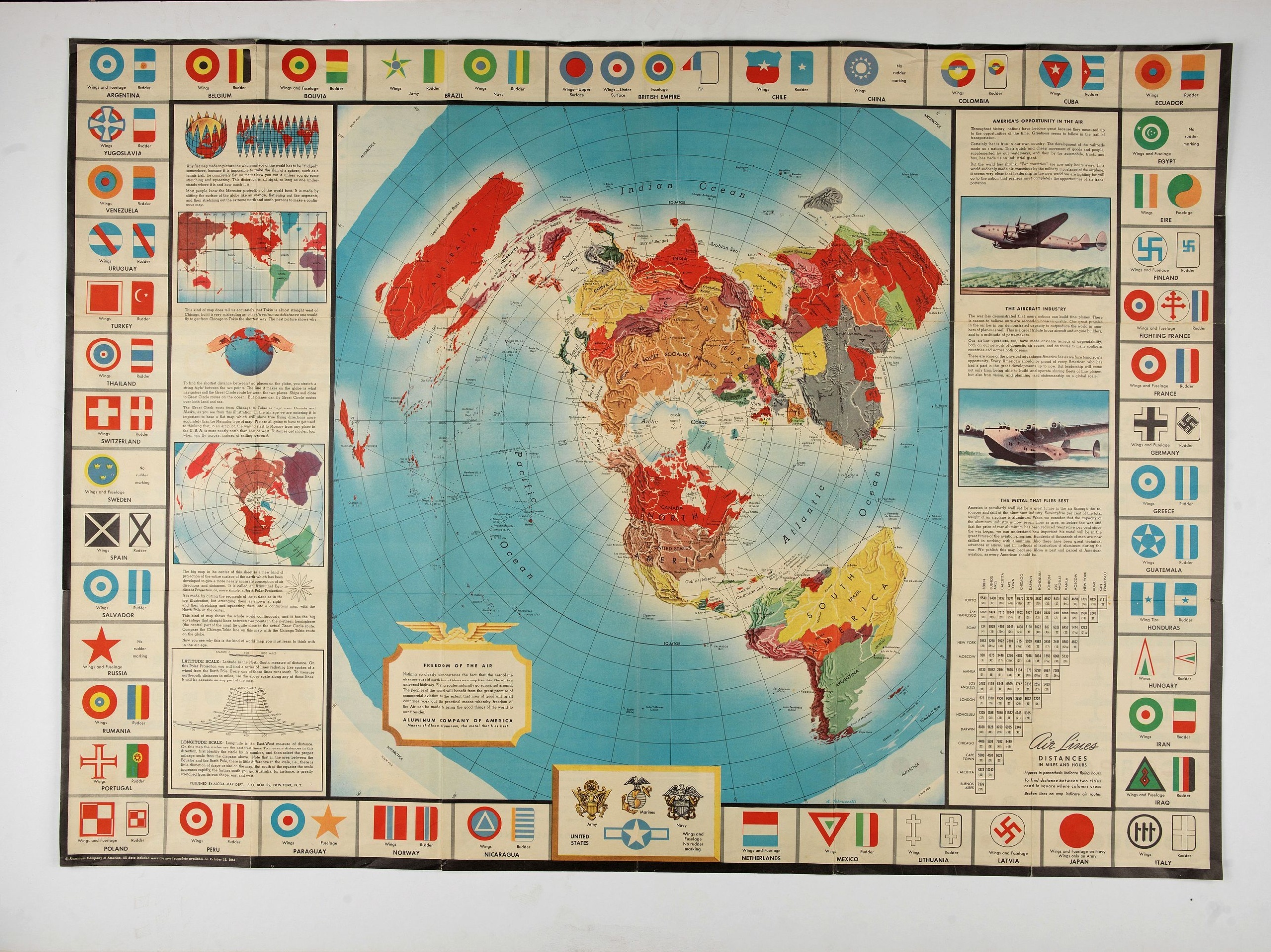
A world map packed with information about aviation and the aluminum industry.The use of aircraft in warfare, especially in the roles of close ground support and strategic bombing, was completely revolutionized during WWII. Apart from tactics, the technology also evolved to facilitate heavier bombers, faster fighters, more capable transports and greater range all-around.
One critical component of this development was using light, flexible and sturdy aluminum frames and skins for the planes, rather than the wood and canvas popularized during WWI.
Alcoa, a major American aluminum manufacturer, was well poised to capitalize on these wartime developments and issued this map to educate the American public about the company’s role in the conflict.
The main image is a world map on a polar projection (or Azimuthal Equidistant, if you want to get technical) which highlights the shortened distances between locations on the globe via air.
The explanatory text regarding the map’s projection and the benefits of aluminum can be found on either side of the map, while the border is comprised of the wing, rudder and tail markings of aircraft from major countries around the world. Interestingly, the belligerent status (Allied, Axis, Neutral) seems to play no part in the selection of the countries depicted. Neutral Spain, “Fighting France,” the Chinese Nationalists, occupied Poland and “Eire” (Ireland) are all shown.
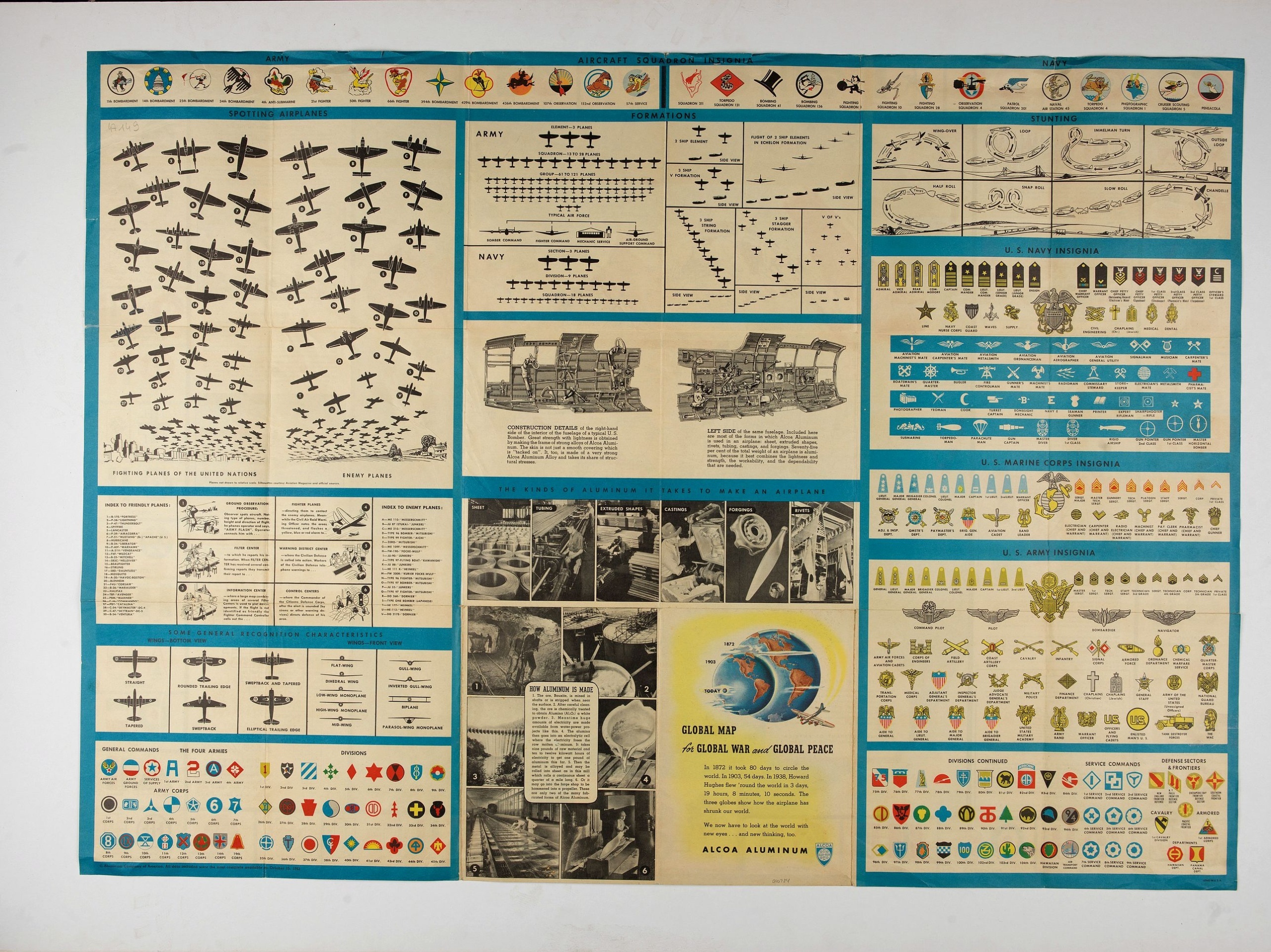
Aviation information continues on the verso of the sheet, which contains numerous charts and diagrams of military insignia, unit logos, profiles of Allied and Axis aircraft, the organizational structure of air corps, and even illustrations of specific dogfighting techniques.
Provincia ecclesiastica di Utrecht Nell' Olanda (Tav LXIII)
This large-format map of The Netherlands with its different dioceses. The map is finely engraved and beautifully colored and was prepared by Girolamo Petri, a lawyer who served as a senior official within the Vatican’s State Secretariat, the arm of the Holy See responsible for managing its relationships with foreign powers. The map shows the various dioceses, which are each distinguished by their own bright colors, marking their seats, as well as other major towns. While key geographical featu...
$300
Maker : PETRI Girolamo
Place : Rome
Date : 1858
![[How the Indians cured the Spanish thirst for gold....by pouring it down their throats!]](/uploads/cache/40483-(1)-500x500.jpg)
[How the Indians cured the Spanish thirst for gold....by pouring it down their throats!]
A brutal scene depicting native Indians tying down Spanish men and pouring liquid gold down their throats. Scenes of cannibalism in the background.In 1631 Johann Ludwig Gottfried, inherited the Theodor De Bry’s publishing firm, among the illustrated accounts of the expeditions of Magellan, Columbus, Vespucci, Cortes, Balboa, Raleigh, Drake, Smith, and many others.Gottfried issued together with Matthaeus Merian a one-volume condensation "Newe Welt Vnd Americanische Historien/ Jnhaltende Warhaff...
$80
Maker : GOTTFRIED, J.L. / DE BRY.
Place : Frankfurt, M.Merian
Date : 1633
Ware affbeeldinge wegens het casteel ende stadt Batavia. . .
A reduced version of Clement de Jonghe (1650) plan of Jakarta from 1650. The town plan has a vignette at the bottom showing Jakarta from the sea with the volcanoes Mount Gede, Mount Pangrnago and Mount Salak in the background. Engraved for Arnoldus Montanus "Gedenkwaerdige gesantschappen der Oost-Indische maatschappy in ’t Vereenigde Nederland. . ." (1669) but reissued by Pieter van der AA.Batavia, present-day Jakarta, the Dutch center of trading activities in the East Indies. European and nat...
$800
Maker : VANDER AA, P.
Place : Leiden
Date : 1719

Gelriae, Cliviae, Finitimorumque Locorum Verissima..
East to the top. Fine map of Geldria and Limburg, prepared by Christian s'Grooten. Very fine title cartouche lower right with painter's utensils around the cartouche.Dare to go in Black. All early maps were printed in black and white, and many were kept that way for a long time. A black and white map in an early and strong impression is a rarity nowadays, being so many examples recently colored up!
$250
Maker : ORTELIUS, A.
Place : Antwerp
Date : 1598
Postage & Shipping
-
Item Location
Terms and conditions - Item Location
- 75013, Ile-de-France, France
- Ships To
- United States, United Kingdom, Albania, Argentina, Armenia, Australia, Azerbaijan, Bahamas, Belgium, Bermuda, Cambodia, Canada, Chile, China, Croatia, Cyprus, Czech Republic, Denmark, Estonia, Finland, France, Germany, Gibraltar, Greece, Greenland, Guatemala, Hong Kong, Iceland, India, Indonesia, Israel, Italy, Japan, Latvia, Lithuania, Luxembourg, Malta, Mexico, Monaco, Netherlands, Norway, Singapore, Spain, Sweden, Switzerland, Turkey
- Pick-ups
- No pick-ups
This item is owned and offered by the seller Paulus_Swaen_Old_Maps - All items are available for immediate sale, offered subject to prior sale.
Invoices are created by the seller by using our shopping cart or be prepared by the seller the day following the order and are emailed to you.
Items offeres by different sellers are invoiced separately.
Shipping fees are extra. The buyer is responsible for all applicable taxes, including any VAT, customs clearance, import duties, or equivalent costs arriving at the customer's home border. Payment is due on receipt of the invoice. The item(s) are shipped as soon as possible after receipt of your payment.
Before buying please read the complete Terms Conditions of Sale.
- Payment Methods
- Visa, Mastercard, Bank Transfer, American Express, iDEAL, PayPal, Google Pay
- Returns Accepted
- No
Post Message
Feel free to ask the seller a question. Please note that the seller could be located in an area with a different time zone. Our seller will do their best to respond within 24 hours.Post your message below.
Sign in to ask the seller a question.

