ID: 158
Closed

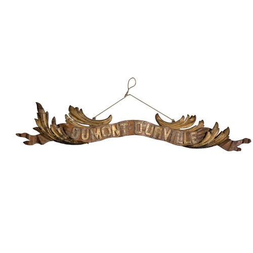
Transom of a ship in gilded carved wood bearing the inscription "DUMONT- DURVILLE"
BuyNow for $7.500
- Maker :
- ANONYMOUS
- Place :
- France
- Date :
- 1880
- Color :
- In original color
- Height mm.:
- 300
- Width mm.:
- 1550
- Condition :
- Carved wood with gilt. Signs of wear.
- Bibliography :
- -
- Seller's ref. :
- 48707
This item is offered by Paulus_Swaen_Old_Maps
See other Items from this seller- Postage
-
Standard Shipping
$0 to France
- Select Country
- Zip/Post Code
- Quantity
$7.500
Description
Decorative transom sign in gilded carved wood bearing the inscription "DUMONT- DURVILLE" in a foliage environment. The transom usually kept the name of the ship and was often well-decorated.A transom is the flat, vertical surface at the back of a ship that connects the two sides of the hull.The sign holds the name of the great French explorer Jules Dumont d'Urville D’Urville who first visited New Zealand in 1824 as second-in-command to Louis Duperrey. On his second voyage of exploration and scientific investigation from 1826, d’Urville commanded the Astrolabe. He spent three months charting the northern coast of the South Island and the east coast of the North Island, also studying the local people, plant and animal life.In the 1830s, d’Urville published scholarly and popular accounts of the voyage of the Astrolabe.
In 1840 he visited New Zealand for the third time, from March until May, approaching from the Auckland Islands and sailing up the east coast of both South and North Islands. Some days were spent in Akaroa Harbour. During this visit Dumont d'Urville charted the coastline, met with Maori and European, and commented on the recent British annexation of New Zealand.
On his return to France Dumont d'Urville was promoted to the rank of rear admiral in December 1840 and was awarded the gold medal of the Société de Géographie, of which he was a foundation member. Again he received a royal command from King Louis-Philippe to publish an account of the voyage. He wrote the first three volumes of Voyage au pôle sud et dans l'Océanie and had completed the first three chapters of the fourth volume when he died with his wife and only surviving son in a railway accident between Bellevue and Meudon on 8 May 1842.Dumont d’Urville (sometimes writen DDU) is the historic French station.
Bibliography
Dumont d'Urville, J. S. C. New Zealand, 1826–1827. Trans. O. Wright. [Wellington, 1950]
Dumont d'Urville, J. S. C. Voyage de la corvette L'Astrolabe : histoire du voyage. 5 vols. Paris, 1830–33
Dumont d'Urville, J. S. C. The voyage of the Astrolabe , 1840. Trans. O. Wright. Wellington, 1955
Dunmore, J. French explorers in the Pacific. Vol. 2, The nineteenth century. Oxford, 1969
Lesson, R. P. Notice historique sur l'amiral Dumont d'Urville. Rochefort, 1846
Ross, J. O'C. This stern coast. Wellington, 1969

Belchrijuinghe vande zee custen van Engelandt. . .
A rare Dutch text edition of this detailed early chart of the northern coast of England. West to the top. The mileage cartouche has no Latin captures. Decorated by a colorful title cartouche and scale cartouche, one compass rose, and several vessels. An early Dutch text edition of this landmark contribution to the science of navigation. Waghenaer's own experiences as a pilot along European coasts were used to compile the Spiegel der Zeevaerdt, the first edition of which was published in Dutch at...
$3.000
Maker : WAGHENAER, L. J.
Place : Leiden, Plantijn
Date : 1585

Brabantiae Descriptio.
In an inset Mechelen and surroundings. Decorative scale and title cartouche with dedicational initials, which may refer to Laurentius Michaelis, who may be connected with the Mechelen inset map.Dare to go in Black. All early maps were printed in black and white, and many were kept that way for a long time. A black and white map in an early and strong impression is a rarity nowadays, being so many examples recently colored up!
$350
Maker : ORTELIUS, A.
Place : Antwerp, 1598
Date : 1598

Mappe-Monde pour connoitre les progres & les conquestes..
Unusual double hemisphere map with California as an Island. Dutch text describes the expeditions and colonial possessions of the Dutch East India Company. The map originated in about 1670. Chatelain acquired the plate; he added decorative elements, including sailing ships, the Dutch crest, and a figure representing Europa seated inside a native fort.Zacharie Chatelain (d.1723) was the father of Henri Abraham (1684-1743) and Zacharie Junior (1690-1754).They worked as a partnership publishing the ...
$800
Maker : CHATELAIN, H.
Place : Amsterdam
Date : 1729

Marine parallel rulers in brass.
Very fine marine parallel rulers in brass. The parallel ruler is the oldest and most traditional way to measure and trace routes and bearings. The principle is simple: the ruler is placed on the road to be measured and then, like a pantograph, the other part of the ruler is placed on one of the declination roses on the map to determine the angle. They are, essentially, two straight-edges hinged so that they maintain the same angle. By alternating the moving edge, and securely holding down the no...
$1.500
Maker : ANONYMOUS
Place : Paris
Date : ca. 1880
Postage & Shipping
-
Item Location
Terms and conditions - Item Location
- Amsterdam, , Netherlands
- Ships To
- United States, United Kingdom, Albania, Argentina, Armenia, Australia, Azerbaijan, Bahamas, Belgium, Bermuda, Cambodia, Canada, Chile, China, Croatia, Cyprus, Czech Republic, Denmark, Estonia, Finland, France, Germany, Gibraltar, Greece, Greenland, Guatemala, Hong Kong, Iceland, India, Indonesia, Israel, Italy, Japan, Latvia, Lithuania, Luxembourg, Malta, Mexico, Monaco, Netherlands, Norway, Singapore, Spain, Sweden, Switzerland, Turkey
- Pick-ups
- No pick-ups
This item is owned and offered by the seller Paulus_Swaen_Old_Maps - All items are available for immediate sale, offered subject to prior sale.
Invoices are created by the seller by using our shopping cart or be prepared by the seller the day following the order and are emailed to you.
Items offeres by different sellers are invoiced separately.
Shipping fees are extra. The buyer is responsible for all applicable taxes, including any VAT, customs clearance, import duties, or equivalent costs arriving at the customer's home border. Payment is due on receipt of the invoice. The item(s) are shipped as soon as possible after receipt of your payment.
Before buying please read the complete Terms Conditions of Sale.
- Payment Methods
- Visa, Mastercard, Bank Transfer, American Express, iDEAL, PayPal, Google Pay
- Returns Accepted
- No
Post Message
Feel free to ask the seller a question. Please note that the seller could be located in an area with a different time zone. Our seller will do their best to respond within 24 hours.Post your message below.
Sign in to ask the seller a question.