
ID: 102
Open
Listing ID: #102 has been added to your wishlist.
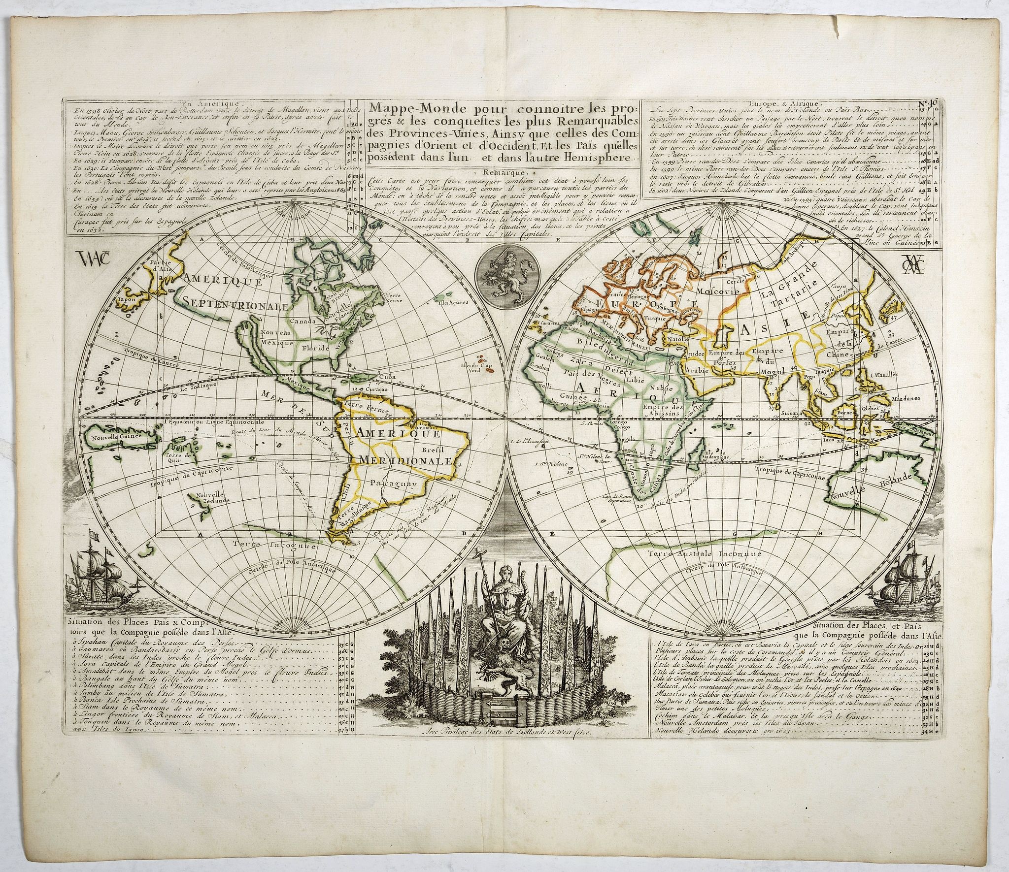
Mappe-Monde pour connoitre les progres & les conquestes..
BuyNow for $800
- Maker :
- CHATELAIN, H.
- Place :
- Amsterdam
- Date :
- 1729
- Color :
- In original outline colors
- Height mm.:
- 335
- Width mm.:
- 460
- Condition :
- Very fine. Rare to find in original outline colors.
- Bibliography :
- -
- Seller's ref. :
- 38863
This item is offered by Paulus_Swaen_Old_Maps
See other Items from this seller- Postage
-
Europe
$34 to Netherlands
- Select Country
- Zip/Post Code
- Quantity
$800
Description
Unusual double hemisphere map with California as an Island. Dutch text describes the expeditions and colonial possessions of the Dutch East India Company.The map originated in about 1670. Chatelain acquired the plate; he added decorative elements, including sailing ships, the Dutch crest, and a figure representing Europa seated inside a native fort.
Zacharie Chatelain (d.1723) was the father of Henri Abraham (1684-1743) and Zacharie Junior (1690-1754).
They worked as a partnership publishing the Atlas Historique, Ou Nouvelle Introduction A L’Histoire … under several different Chatelain imprints, depending on the Chatelain family partnerships at the time of publication.

Very fine brass astronomical equinoctial ring with two brass circles.
Very fine brass astronomical equinoctial ring with two brass circles with engraved foliage decoration, signed "Jean-Baptiste-Nicolas Delure A Paris", on the hanger ring. The meridian ring is engraved with a latitude scale 90-0-90 degrees, reverse with a scale for determining solar altitude and zennith distance, an equinoctial ring with obverse engraved with hour scale in Roman numerals, the central bridge with pin-hole sliding over calendar and zodiac scales, 100 mm diam.Jean-Baptiste-Nicolas De...
$8.000
Maker : JEAN-BAPTISTE NICOLAS DELURE À PARIS
Place : Paris
Date : ca. 1690

Inventio Maris Magallanici.
Allegorical scene allegorical image celebrating the circumnavigation of the earth by Ferdinand Magellan. The image shows Magellan on board of his ship, surrounded by mythological figures including Apollo with sun and lyre, Zeus on his throne of clouds, Adam and Eve. A bird carrying an elephant and a depiction of the Tierra del Fuego.The image also includes cannon, banner with the double-headed Hapsburg eagle, anchor, broken mast, navigational instruments such as armillary sphere and dividers, se...
$750
Maker : DE BRY, Th.
Place : Frankfurt
Date : 1594

Kaerte en Afbeeldinge vande Geheele Jurisdictie van Stantdarbuyten Gelegen in de Generaliteit onder Marquisaet van Bergen op den Zoom
With a large title cartouche with signature of the maker Adriaan van der Ende, : Kaerte en Afbeeldinge vande Geheele Jurisdictie van Stantdarbuyten Gelegen in de Generaliteit onder Marquisaet van Bergen op den Zoom, gemaekt, en in den Jare van 1733, 1734, 1735 gemeten by my ondergetz… Willemstadt den 8 Julij 1737 Adr: van Enden.Adriaan van de Ende was a surveyor, appointed by the Council of Brabant in 1720, then living in Heyningen. Was later living and active in Willemstad.Other manuscript m...
$2.500
Maker : VAN DE ENDEN, A.
Place : Willemstadt
Date : 1737

Belchrijuinghe vande zee custen van Engelandt. . .
A rare Dutch text edition of this detailed early chart of the northern coast of England. West to the top. The mileage cartouche has no Latin captures. Decorated by a colorful title cartouche and scale cartouche, one compass rose, and several vessels. An early Dutch text edition of this landmark contribution to the science of navigation. Waghenaer's own experiences as a pilot along European coasts were used to compile the Spiegel der Zeevaerdt, the first edition of which was published in Dutch at...
$3.000
Maker : WAGHENAER, L. J.
Place : Leiden, Plantijn
Date : 1585
Postage & Shipping
-
Item Location
Terms and conditions - Item Location
- Amsterdam, , Netherlands
- Ships To
- United States, United Kingdom, Albania, Argentina, Armenia, Australia, Azerbaijan, Bahamas, Belgium, Bermuda, Cambodia, Canada, Chile, China, Croatia, Cyprus, Czech Republic, Denmark, Estonia, Finland, France, Germany, Gibraltar, Greece, Greenland, Guatemala, Hong Kong, Iceland, India, Indonesia, Israel, Italy, Japan, Latvia, Lithuania, Luxembourg, Malta, Mexico, Monaco, Netherlands, Norway, Singapore, Spain, Sweden, Switzerland, Turkey
- Pick-ups
- No pick-ups
This item is owned and offered by the seller Paulus_Swaen_Old_Maps - All items are available for immediate sale, offered subject to prior sale.
Invoices are created by the seller by using our shopping cart or be prepared by the seller the day following the order and are emailed to you.
Items offeres by different sellers are invoiced separately.
Shipping fees are extra. The buyer is responsible for all applicable taxes, including any VAT, customs clearance, import duties, or equivalent costs arriving at the customer's home border. Payment is due on receipt of the invoice. The item(s) are shipped as soon as possible after receipt of your payment.
Before buying please read the complete Terms Conditions of Sale.
- Payment Methods
- Visa, Mastercard, Bank Transfer, iDEAL, PayPal, Google Pay
- Returns Accepted
- No
Post Message
Feel free to ask the seller a question. Please note that the seller could be located in an area with a different time zone. Our seller will do their best to respond within 24 hours.Post your message below.
Sign in to ask the seller a question.
