ID: 302
Open

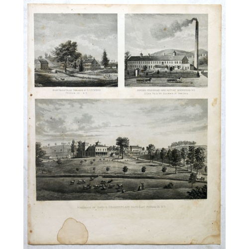
Mount Vernon Valley Residence of S.J. Powers / Borden condensed milk factory brewsters N.Y / Residence of Dan D. Chamberlain South East Putman Co. N.Y.
BuyNow for $90
- Maker :
- DE BEERS, F.W.
- Place :
- New York
- Date :
- 1867
- Color :
- Uncolored
- Height mm.:
- 365
- Width mm.:
- 320
- Condition :
- Sheet size: 440 x 320mm. Marginal staining.
- Bibliography :
- -
- Seller's ref. :
- 37913
This item is offered by Paulus_Swaen_Old_Maps
See other Items from this seller- Postage
-
Europe
$34 to France
- Select Country
- Zip/Post Code
- Quantity
$90
Description
Three heliographic prints on one sheet : "Mount Vernon Valley Residence of S.J. Powers (135 x 155mm.) / Borden condensed milk factory brewsters N.Y (135 x 155mm.) / Residence of Dan D. Chamberlain South East Putman Co. N.Y. (190 x 155mm.) " after design by R.K.Sneden.
Beers first published his Atlas of New York & Vicinity in 1867. It has been observed by McCorkle and others that various issues of the atlas were published in that year and the following with significant differences in the number and selection of maps included by the publisher. This was the result of clever marketing by Beers, intending to sell the atlases to customers in specific regions.
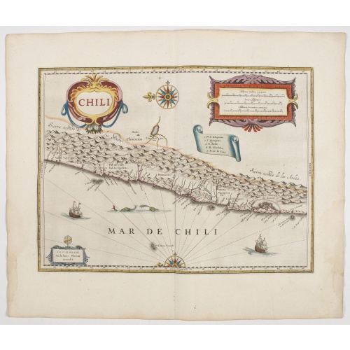
Chili.
Willem Blaeu's very decorative map of Chili with two large and beautiful cartouches, a compass and ships. From early on Willem Jansz. Blaeu aimed of publishing an atlas to compete with the Hondius-Janssonius Atlas. By 1630, he had published at least 17 folio size maps. Blaeu was able to realize his plan soon after he had acquired the copper plates of the atlas maps by Jodocus Hondius. The "Appendix followed in 1630.In 1635 he finally realized a "international edition" of a world atlas, the "The...
$900
Maker : BLAEU, W.
Place : Amsterdam, 1644
Date : 1644
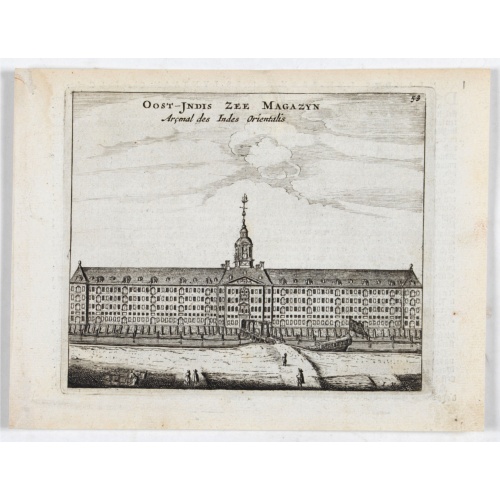
Oost-Indis Zee Magazyn - Arçenal des Indes Orientalis.
Decorative view of the East Indian Arsenal, now-a-says the Maritime Museum.
$150
Maker : ANONYMOUS
Place : Amsterdam
Date : ca. 1700
![[Murder of Dominican monks in Cumana or Cubagua Island].](/uploads/cache/40177-500x500.jpg)
[Murder of Dominican monks in Cumana or Cubagua Island].
Murder of Dominican monks in Cumana or Cubagua Island in what is now Venezuela. Scarce print (150x177mm.) on a German text sheet taken from a first edition of Johann Ludwig Gottfried's "Newe Welt Vnd Americanische Historien/ Jnhaltende Warhafftige vnd volkommene Beschreibungen Aller West-Indianischen Landschafften…" published by M.Merian in 1631.
$80
Maker : GOTTFRIED, J.L. / DE BRY, T.
Place : Frankfurt, M.Merian
Date : 1633
![[French seizure of Chiorera.]](/uploads/cache/39911-500x500.jpg)
[French seizure of Chiorera.]
Scarce print with a German text sheet showing the French torching and looting Chiorera. From de Bry's "Great American Voyages". Johann Theodor de Bry (1561-1623) was born in Liège in 1561, the eldest son of the engraver and publisher Theodor de Bry. It was from his father that Johann learned his craft, producing both engravings and etchings. In 1588, the Lutheran De Bry family settled in Frankfurt am Main, a safe haven for Lutherans at this time of religious discord. Together with his father an...
$80
Maker : GOTTFRIED, J.L. / DE BRY.
Place : Frankfurt, M.Merian
Date : 1633
Postage & Shipping
-
Item Location
Terms and conditions - Item Location
- 75013, Ile-de-France, France
- Ships To
- United States, United Kingdom, Albania, Argentina, Armenia, Australia, Azerbaijan, Bahamas, Belgium, Bermuda, Cambodia, Canada, Chile, China, Croatia, Cyprus, Czech Republic, Denmark, Estonia, Finland, France, Germany, Gibraltar, Greece, Greenland, Guatemala, Hong Kong, Iceland, India, Indonesia, Israel, Italy, Japan, Latvia, Lithuania, Luxembourg, Malta, Mexico, Monaco, Netherlands, Norway, Singapore, Spain, Sweden, Switzerland, Turkey
- Pick-ups
- No pick-ups
This item is owned and offered by the seller Paulus_Swaen_Old_Maps - All items are available for immediate sale, offered subject to prior sale.
Invoices are created by the seller by using our shopping cart or be prepared by the seller the day following the order and are emailed to you.
Items offeres by different sellers are invoiced separately.
Shipping fees are extra. The buyer is responsible for all applicable taxes, including any VAT, customs clearance, import duties, or equivalent costs arriving at the customer's home border. Payment is due on receipt of the invoice. The item(s) are shipped as soon as possible after receipt of your payment.
Before buying please read the complete Terms Conditions of Sale.
- Payment Methods
- Visa, Mastercard, Bank Transfer, American Express, iDEAL, PayPal, Google Pay
- Returns Accepted
- No
Post Message
Feel free to ask the seller a question. Please note that the seller could be located in an area with a different time zone. Our seller will do their best to respond within 24 hours.Post your message below.
Sign in to ask the seller a question.