ID: 70
Open

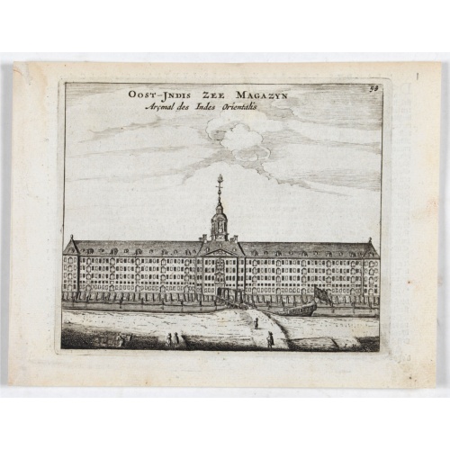
Oost-Indis Zee Magazyn - Arçenal des Indes Orientalis.
BuyNow for $150
- Maker :
- ANONYMOUS
- Place :
- Amsterdam
- Date :
- ca. 1700
- Color :
- Uncolored.
- Height mm.:
- 114
- Width mm.:
- 135
- Condition :
- Some age toning of paper. Faint discolor along left margin, hardly noticeable. Else good condition.
- Bibliography :
- -
- Seller's ref. :
- 22705
This item is offered by Paulus_Swaen_Old_Maps
See other Items from this seller- Postage
-
Europe
$34 to France
- Select Country
- Zip/Post Code
- Quantity
$150
Description
Decorative view of the East Indian Arsenal, now-a-says the Maritime Museum.
Straat Riouw onder opzicht van de commissie tot verbetering der Indische Zeekaarten..
Very large and rare so-called Blue Back chart centered on the strait passing between the Riau Islands. It contains an inset map with enlarged details of Riouw Harbor on Bintang Island.Coastal profiles are shown in the lower-left corner of the chart.The chart is prepared by W.H.Dittlof Tjassens, P.A.J.Bloijs van Treslong Prins and J.van Gogh during an expedition in 1840 by the ship Nehalennia under the command of Captain F.G.van der Plaat. The chart is engraved by D.Veelwaard Jr. And published in...
$1.250
Maker : HULST VAN KEULEN, Wed.G.
Place : Amsterdam
Date : 1843
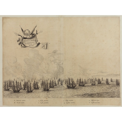
Quartum Praelium Coniovian inter et Fluvium Rio Grande XVII Ian
Decorative engraving of the fourth sea battle with the Portuguese fleet offshore at the Rio Grande, in 1640. Engraved by J. van Brosterhuyzen after a design by Frans J. Post (1612-1680). Below the engraving a numbered key (1-6). Signed in the plate "F. Post 1645" and decorative title cartouche, with "[Quartum praelium coniovian inter et fluvium Rio Grande XVII Jan" in the upper left corner.Taken from C. BARLAEUS, Rerum per octennium in Brasilia (...).
$450
Maker : POST, F. J.
Place : Joannes Blaeu, Amsterdam 1647
Date : 1647
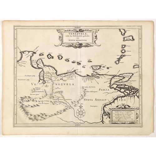
Venezuela, atque Occidentalis Pars Novæ Andalusiae.
Coastline of Venezuela with little interior development. Including Aruba, Bonaire, Curaçao, etc. Scarce map prepared by Hessel Gerritsz (1581-1632), former apprentice of Willem Blaeu, and Blaeu’s predecessor as chief cartographer of the Dutch East India Company. Gerritsz enjoys a very high reputation for his critical approach towards his sources.Most of Gerritsz’ work exists only in manuscript, and these maps published by de Laet, are among the only printed Gerritsz maps available to the co...
$600
Maker : LAET, DE J. / GERITSZ, H.
Place : Leiden, Elzevier
Date : 1630
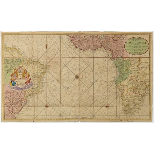
Nieuwe Wassende Graadige Pas-kaart van de Kust van Guinea en Brasilia.
Rare two-sheet sea chart of the coasts of Brazil, West Africa and South Africa, published by Johannes Van Keulen (the younger), circa 1720.The chart shows the western coast of Africa but the information provided in the map for Inland territories is wide. The South American coast of Brazil, the latter with a large, decorative, dedication cartouche inland, and Guyana. In the left-hand part a large dedicational cartouche to Abraham Anias, with the signature of Johannes van Keulen.Abraham Anias (169...
$2.250
Maker : VAN KEULEN, G.
Place : Amsterdam
Date : 1751
Postage & Shipping
-
Item Location
Terms and conditions - Item Location
- Amsterdam, , Netherlands
- Ships To
- United States, United Kingdom, Albania, Argentina, Armenia, Australia, Azerbaijan, Bahamas, Belgium, Bermuda, Cambodia, Canada, Chile, China, Croatia, Cyprus, Czech Republic, Denmark, Estonia, Finland, France, Germany, Gibraltar, Greece, Greenland, Guatemala, Hong Kong, Iceland, India, Indonesia, Israel, Italy, Japan, Latvia, Lithuania, Luxembourg, Malta, Mexico, Monaco, Netherlands, Norway, Singapore, Spain, Sweden, Switzerland, Turkey
- Pick-ups
- No pick-ups
This item is owned and offered by the seller Paulus_Swaen_Old_Maps - All items are available for immediate sale, offered subject to prior sale.
Invoices are created by the seller by using our shopping cart or be prepared by the seller the day following the order and are emailed to you.
Items offeres by different sellers are invoiced separately.
Shipping fees are extra. The buyer is responsible for all applicable taxes, including any VAT, customs clearance, import duties, or equivalent costs arriving at the customer's home border. Payment is due on receipt of the invoice. The item(s) are shipped as soon as possible after receipt of your payment.
Before buying please read the complete Terms Conditions of Sale.
- Payment Methods
- Visa, Mastercard, Bank Transfer, iDEAL, PayPal, Google Pay
- Returns Accepted
- No
Post Message
Feel free to ask the seller a question. Please note that the seller could be located in an area with a different time zone. Our seller will do their best to respond within 24 hours.Post your message below.
Sign in to ask the seller a question.