ID: 245
Open
.jpg)
Peru.
BuyNow for $900
- Maker :
- BLAEU, W.
- Place :
- Amsterdam
- Date :
- 1644
- Color :
- Original colors
- Height mm.:
- 375
- Width mm.:
- 490
- Condition :
- Very good condition, with a dark impression. French text on verso.
- Bibliography :
- V.d.Krogt, Atlantes Neerlandici.
- Seller's ref. :
- 45265
This item is offered by Paulus_Swaen_Old_Maps
See other Items from this seller- Postage
-
Europe
$34 to France
- Select Country
- Zip/Post Code
- Quantity
$900
Description
FIRST EDITION, FIRST ISSUE OF THIS MAP. Decorated with ships and monsters in the sea. Orientated with east at the top. With the signature of G. Blaeuw lower right corner. Shows the Pacific coast of South America from Ecuador (at the left-hand side) as far south as the Atacama desert in the northern reaches of Chile."As early as 1520, Spanish settlers in Panama had heard tales of a powerful civilization rich in gold that lay to the south, and in 1522 an expedition was organized to find this land and the people called Birú or Pirú in the south.
In 1524 Francisco Pizarro led the first of his expeditions that led ultimately to the discovery and conquest of the Inca empire which extended over wide areas of modern Ecuador, Peru, Bolivia and part of Chile.
Pizarro obtained from Atahuallpa, the head of the Inca empire, a huge ransom of silver and gold that made Spain rich almost beyond the most inventive dreams of the Spanish conquerors, and once the mountain city of Cuzco was captured in 1533, the Spanish hold over much of South America was virtually complete." (John Goss)
From early on Willem Jansz. Blaeu aimed of publishing an atlas to compete with the Hondius-Jansson Atlas. By 1630, he had published at least 17 folio size maps. Blaeu was able to realize his plan soon after he had acquired the copper plates of the atlas maps by Jodocus Hondius. The "Appendix followed in 1630.
In 1635 he finally realized a "international edition" of a world atlas, the "Theatrum Orbis Terrarum".
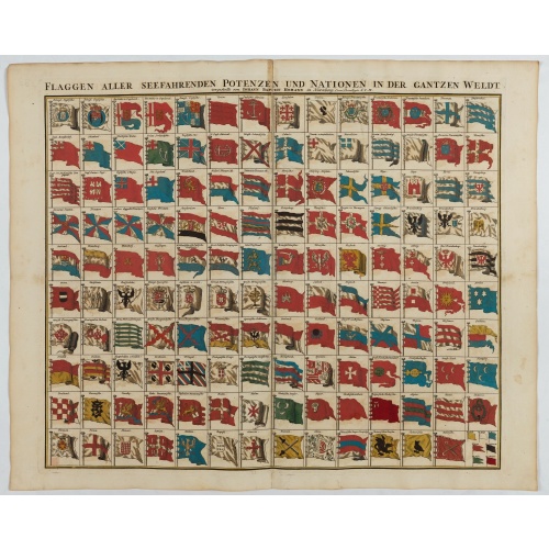
Flaggen aller seefahrenden potenzen und nationen…
A highly decorative and beautiful print with 139 flags of the sea-faring nations, factions, and trading companies. Among the more interesting flags are those of the Dutch West India Company (G.WC. /Geoctroyeerde Westindische Compagnie) and the Dutch East India Company (V.O.C. / Vereenigde Oostindische Compagnie). This plate is probably derived from a Dutch flag print issued by Cornelis Danckerts c. 1700.
$1.000
Maker : HOMANN, J.B.
Place : Nuremberg
Date : 1750
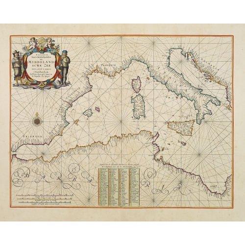
Pascaerte Van't Westelyckste der Middelandsche Zee. . .
An eye-catching chart of the western part of the Mediterranean Sea.Pieter Goos (ca. 1616-1675) was one of the most important cartographer, engraver, publisher and print seller of Amsterdam. His widow continued business at her husband's death. She re-issued the Nieuwe Groote Zee-Spiegel in 1676.In very decorative original colors. The compass rose and cartouche heightened with gold.The map is in a strictly contemporary coloring and of the highest level.
$3.750
Maker : GOOS, P.
Place : Amsterdam
Date : 1666
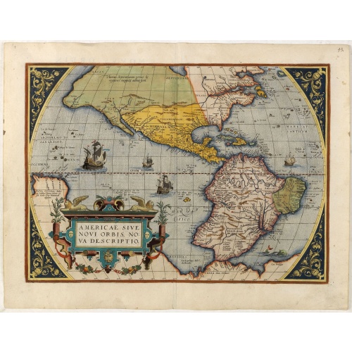
Americae Sive Novi Orbis, Nova Descriptio.
This is the second copperplate of Ortelius'.
$5.500
Maker : ORTELIUS, A.
Place : Antwerp
Date : 1579
![[Cavendish reaches Morro Moreno.]](/uploads/cache/39910-500x500.jpg)
[Cavendish reaches Morro Moreno.]
Scarce print with a German text sheet showing Cavendish’s fleet anchor at a place called Morro Moreno, on the coast of Chile. The Indians came down from the high cliffs to greet the voyagers and brought with them firewood and fresh water as a sign of friendship. Later the English were taken to their homes, which were made from two sticks in the ground, with others laid across and covered with straw. The whole family, including children, lay underneath on animal skins. They were skilled fisherm...
$80
Maker : GOTTFRIED, J.L. / DE BRY.
Place : Frankfurt, M.Merian
Date : 1633
Postage & Shipping
-
Item Location
Terms and conditions - Item Location
- 75013, Ile-de-France, France
- Ships To
- United States, United Kingdom, Albania, Argentina, Armenia, Australia, Azerbaijan, Bahamas, Belgium, Bermuda, Cambodia, Canada, Chile, China, Croatia, Cyprus, Czech Republic, Denmark, Estonia, Finland, France, Germany, Gibraltar, Greece, Greenland, Guatemala, Hong Kong, Iceland, India, Indonesia, Israel, Italy, Japan, Latvia, Lithuania, Luxembourg, Malta, Mexico, Monaco, Netherlands, Norway, Singapore, Spain, Sweden, Switzerland, Turkey
- Pick-ups
- No pick-ups
This item is owned and offered by the seller Paulus_Swaen_Old_Maps - All items are available for immediate sale, offered subject to prior sale.
Invoices are created by the seller by using our shopping cart or be prepared by the seller the day following the order and are emailed to you.
Items offeres by different sellers are invoiced separately.
Shipping fees are extra. The buyer is responsible for all applicable taxes, including any VAT, customs clearance, import duties, or equivalent costs arriving at the customer's home border. Payment is due on receipt of the invoice. The item(s) are shipped as soon as possible after receipt of your payment.
Before buying please read the complete Terms Conditions of Sale.
- Payment Methods
- Visa, Mastercard, Bank Transfer, American Express, iDEAL, PayPal, Google Pay
- Returns Accepted
- No
Post Message
Feel free to ask the seller a question. Please note that the seller could be located in an area with a different time zone. Our seller will do their best to respond within 24 hours.Post your message below.
Sign in to ask the seller a question.
-500x500.jpg)