ID: 214
Open
Listing ID: #214 has been added to your wishlist.
![Groeninga MDLXXIII. [Groningen]](/uploads/27192.jpg)
Groeninga MDLXXIII. [Groningen]
BuyNow for $60
- Maker :
- MUNSTER, S.
- Place :
- Basle, ca. 1564
- Date :
- 1564
- Color :
- Uncoloured
- Height mm.:
- 125
- Width mm.:
- 155
- Condition :
- In very good condition. Wood block print with letter press.
- Bibliography :
- -
- Seller's ref. :
- 27192
This item is offered by Paulus_Swaen_Old_Maps
See other Items from this seller- Postage
-
America
$34 to United States
- Select Country
- Zip/Post Code
- Quantity
$60
Description
RECTO: A panoramic view of the city of Groningen dated 1573.VERSO: a woodcut of a cow, a bull and their calf.
Taken from Sebastian Munster's encyclopedic work, the "Cosmographia Universalis". The Cosmographia by Sebastian Münster had numerous editions in different languages including Latin, French (translated by François de Belleforest), Italian, English, and even Czech. The last German edition was published in 1628, long after his death.
The Cosmographia was one of the most successful and popular books of the 16th century. It passed through 24 editions in 100 years. This success was due to the fascinating woodcuts (some by Hans Holbein the Younger, Urs Graf, Hans Rudolph Manuel Deutsch, and David Kandel). It was most important in reviving geography in 16th century Europe.
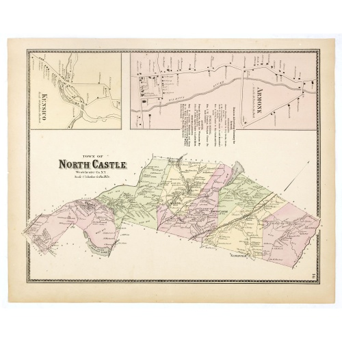
Town of North Castle.
Fine lithographed map of the town of North Castle. The map provides the names of specific homeowners, as well as information about the occupations and physical locations of the various tradesmen in each village from Beer's famous county atlas "Atlas of New York and vicinity, a documentary record of nineteenth-century life and delightful specimens of American folk art." F. W. Beers, along with other members of his family, were among the leading county atlas publishers in the period immediately fo...
$90
Maker : DE BEERS, F.W.
Place : New York
Date : 1867
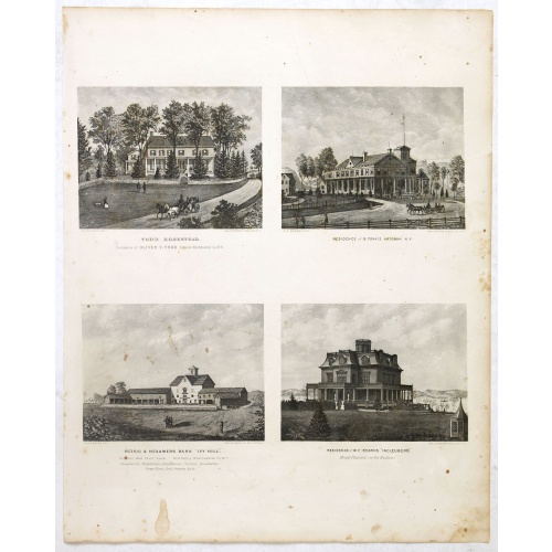
Todd Homestead / Résidence of B. Travis Katonah N.Y / Reisig & HexamersBarn Ivy Hill / Résidence of W.F Bearns
Four heliographic prints on one sheet : "Todd Homestead / Résidence of B. Travis Katonah N.Y / Reisig & HexamersBarn Ivy Hill / Résidence of W.F Bearns "Ingleuberg". After design by R.K.Sneden.From Beer's famous county atlas "Atlas of New York and vicinity", "a documentary record of nineteenth century life and delightful specimens of American folk art".F. W. Beers, along with other members of his family, were among the leading county atlas publishers in period immediately following the Civil W...
$90
Maker : DE BEERS, F.W.
Place : New York
Date : 1867
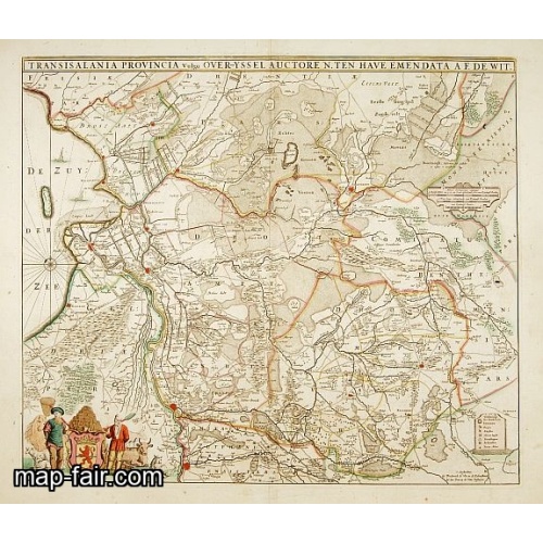
Transisalania provincia vulgo Over-Yssel auctore N.ten Have
Detailed map prepared by Nico ten Have.
$300
Maker : DE WIT, F.
Place : Amsterdam
Date : 1690

Brabantiae Descriptio.
In an inset Mechelen and surroundings. Decorative scale and title cartouche with dedicational initials, which may refer to Laurentius Michaelis, who may be connected with the Mechelen inset map.Dare to go in Black. All early maps were printed in black and white, and many were kept that way for a long time. A black and white map in an early and strong impression is a rarity nowadays, being so many examples recently colored up!
$350
Maker : ORTELIUS, A.
Place : Antwerp, 1598
Date : 1598
Postage & Shipping
-
Item Location
Terms and conditions - Item Location
- 75013, Ile-de-France, France
- Ships To
- United States, United Kingdom, Albania, Argentina, Armenia, Australia, Azerbaijan, Bahamas, Belgium, Bermuda, Cambodia, Canada, Chile, China, Croatia, Cyprus, Czech Republic, Denmark, Estonia, Finland, France, Germany, Gibraltar, Greece, Greenland, Guatemala, Hong Kong, Iceland, India, Indonesia, Israel, Italy, Japan, Latvia, Lithuania, Luxembourg, Malta, Mexico, Monaco, Netherlands, Norway, Singapore, Spain, Sweden, Switzerland, Turkey
- Pick-ups
- No pick-ups
This item is owned and offered by the seller Paulus_Swaen_Old_Maps - All items are available for immediate sale, offered subject to prior sale.
Invoices are created by the seller by using our shopping cart or be prepared by the seller the day following the order and are emailed to you.
Items offeres by different sellers are invoiced separately.
Shipping fees are extra. The buyer is responsible for all applicable taxes, including any VAT, customs clearance, import duties, or equivalent costs arriving at the customer's home border. Payment is due on receipt of the invoice. The item(s) are shipped as soon as possible after receipt of your payment.
Before buying please read the complete Terms Conditions of Sale.
- Payment Methods
- Payment Simulator, Visa, Mastercard, Bank Transfer, PayPal
- Returns Accepted
- No
Post Message
Feel free to ask the seller a question. Please note that the seller could be located in an area with a different time zone. Our seller will do their best to respond within 24 hours.Post your message below.
Sign in to ask the seller a question.
![Groeninga MDLXXIII. [Groningen]](/uploads/cache/27192-500x500.jpg)