ID: 148
Open

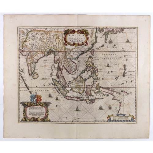
India quae Orientalis dicitur, et Insulae adiacentes.
BuyNow for $1.850
- Maker :
- JANSSONIUS, J. / HONDIUS, H.
- Place :
- Amsterdam
- Date :
- 1640
- Color :
- Color printed
- Height mm.:
- 393
- Width mm.:
- 489
- Condition :
- Printed on heavy paper. Some very light offsetting of colors, but overall in very fine condition. German text on verso.
- Bibliography :
- -
- Seller's ref. :
- 40680
This item is offered by Paulus_Swaen_Old_Maps
See other Items from this seller- Postage
-
Standard Shipping
$0 to Netherlands
- Select Country
- Zip/Post Code
- Quantity
$1.850
Description
A fine map of South East Asia, extending from India to Tibet to Japan to New Guinea. Formosa appears on this map, and even parts of Japan and Australia are seen. A handsome map in the typically baroque Dutch style.Noteworthy for being the second map to include the discoveries made in New Guinea and northern Queensland, Australia by the Dutch vessel Duyfken in 1605-06. Under the command of Willem Janzoon, the Duyfken explored the eastern shore of the Gulf of Carpentaria, just below the Cape York Peninsula, a venture which was famously the first recorded European contact with Australia.
The map includes South East Asia in general with all of Malaysia, the East Indies, the Philippines, Indonesia, Indochina and southern China with the Pearl River Delta, Taiwan, and part of Japan. Richly embellished with 3 cartouches, coats of arms, 2 compass roses, a sea monster and 6 sailing vessels.

De zee cuften tufschen Dovere en Orfords nesse, daer de Teemse de Vermaerde Rivire van Lonen gelegens is. . .
A detailed chart of the English Channel coastland. Decorated by a colorful title cartouche and scale cartouche, one compass rose, several vessels and sea monsters. A very early edition rare Dutch text edition of this landmark contribution to the science of navigation. Waghenaer's own personal experiences as a pilot along European coasts were used to compile the Spiegel der Zeevaerdt, the first edition of which was published in Dutch at Leyden in 1584/85 by the House of Plantin. Although advertis...
$3.000
Maker : WAGHENAER, L. J.
Place : Leiden, Plantijn
Date : 1585
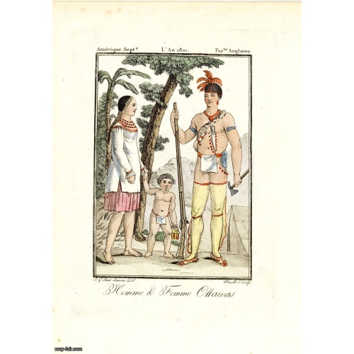
Homme & Femme Ottawas.
Hand-colored mezzotint of Native Americans engraved by Félix Mixelle and Lachaussée Jeune after Jacques Grasset de Saint-Sauveur.As an etcher, drawer and writer, Grasset de Saint-Sauveur was a prolific polygraph in keeping with the encyclopedic spirit of the eighteenth century: he wrote exotic novels as well as documentary works on various subjects. Called by one of his biographers a drawer without genius but a good example of the taste of his time, Grasset de Saint-Sauveur was literally bewit...
$75
Maker : GRASSET DE SAINT SAUVEUR,J.
Place : Paris,
Date : 1806
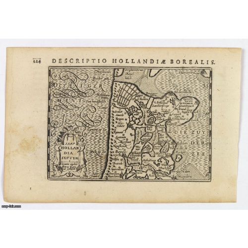
Hollandia Septentrionalis.
An attractive miniature map of the north Holland, northwards from Amsterdam to the Zijpe polder, published by Petrus Bertius, in Amsterdam at the beginning of the seventeenth century. It features a decorative title, sea hatching, elaborate cursive script, dykes and polders, some towns etc.This example is from the Tabularum Geographicarum Contractarum. Bertius (1565-1629) was a Flemish cartographer, theologian, historian and geographer. Although he published much in the fields of history, theolog...
$150
Maker : LANGENES, B. / BERTIUS, P.
Place : Amsterdam
Date : 1606
![Groeninga MDLXXIII. [Groningen]](/uploads/cache/27192-500x500.jpg)
Groeninga MDLXXIII. [Groningen]
RECTO: A panoramic view of the city of Groningen dated 1573.VERSO: a woodcut of a cow, a bull and their calf.Taken from Sebastian Munster's encyclopedic work, the "Cosmographia Universalis". The Cosmographia by Sebastian Münster had numerous editions in different languages including Latin, French (translated by François de Belleforest), Italian, English, and even Czech. The last German edition was published in 1628, long after his death. The Cosmographia was one of the most successful and popu...
$60
Maker : MUNSTER, S.
Place : Basle, ca. 1564
Date : 1564
Postage & Shipping
-
Item Location
Terms and conditions - Item Location
- Clearwater, Alabama, United States
- Ships To
- United States, United Kingdom, Albania, Argentina, Armenia, Australia, Azerbaijan, Bahamas, Belgium, Bermuda, Cambodia, Canada, Chile, China, Croatia, Cyprus, Czech Republic, Denmark, Estonia, Finland, France, Germany, Gibraltar, Greece, Greenland, Guatemala, Hong Kong, Iceland, India, Indonesia, Israel, Italy, Japan, Latvia, Lithuania, Luxembourg, Malta, Mexico, Monaco, Netherlands, Norway, Singapore, Spain, Sweden, Switzerland, Turkey
- Pick-ups
- No pick-ups
This item is owned and offered by the seller Paulus_Swaen_Old_Maps - All items are available for immediate sale, offered subject to prior sale.
Invoices are created by the seller by using our shopping cart or be prepared by the seller the day following the order and are emailed to you.
Items offeres by different sellers are invoiced separately.
Shipping fees are extra. The buyer is responsible for all applicable taxes, including any VAT, customs clearance, import duties, or equivalent costs arriving at the customer's home border. Payment is due on receipt of the invoice. The item(s) are shipped as soon as possible after receipt of your payment.
Before buying please read the complete Terms Conditions of Sale.
- Payment Methods
- Payment Simulator, Visa, Mastercard, Bank Transfer, American Express, iDEAL, PayPal, Google Pay
- Returns Accepted
- No
Post Message
Feel free to ask the seller a question. Please note that the seller could be located in an area with a different time zone. Our seller will do their best to respond within 24 hours.Post your message below.
Sign in to ask the seller a question.