
ID: 154
Closed
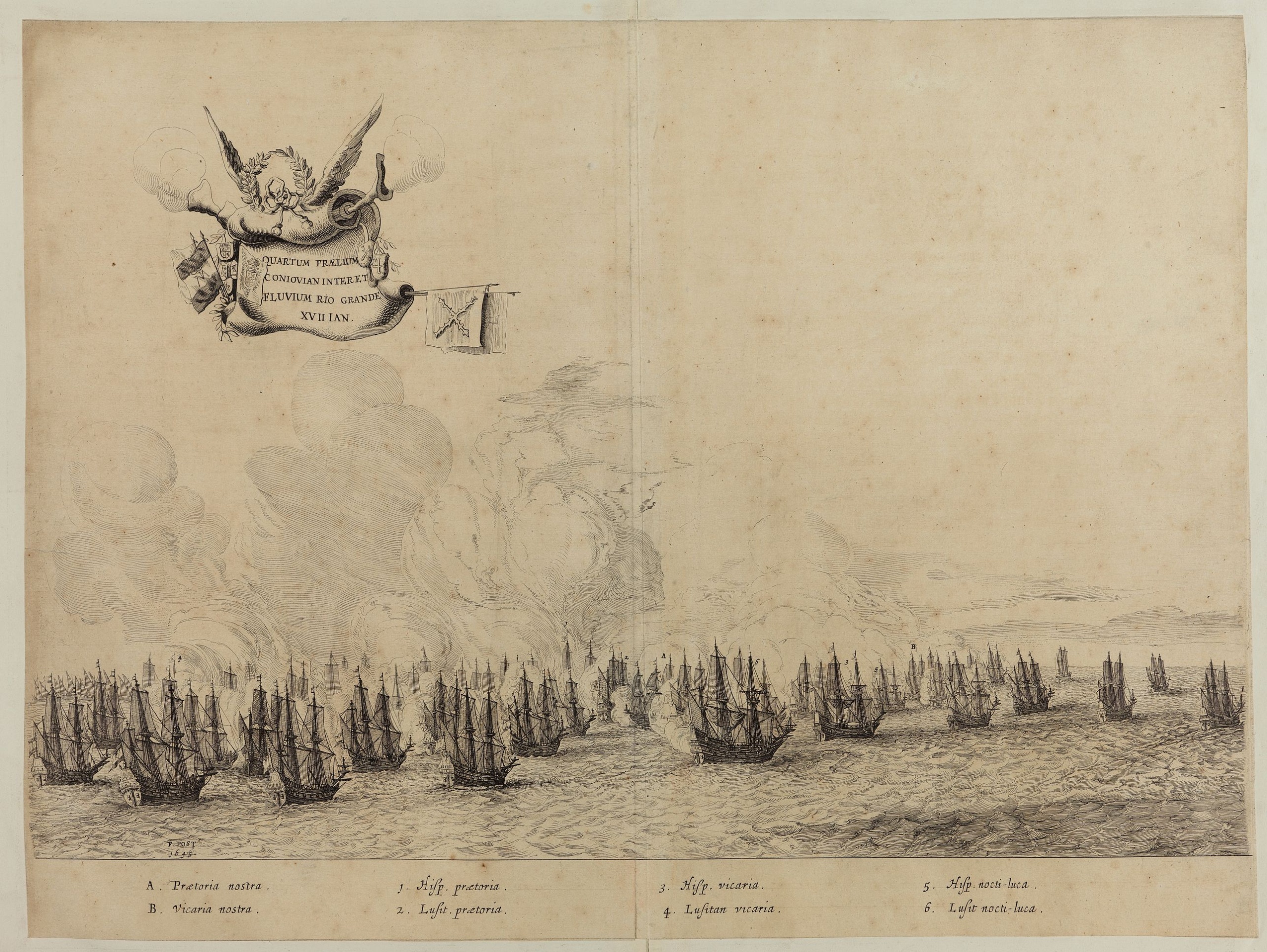
Quartum Praelium Coniovian inter et Fluvium Rio Grande XVII Ian
BuyNow for $450
- Maker :
- POST, F. J.
- Place :
- Joannes Blaeu, Amsterdam 1647
- Date :
- 1647
- Color :
- Uncoloured
- Height mm.:
- 350
- Width mm.:
- 510
- Condition :
- Cut on plate mark and laid down on a larger sheet. Center fold and paper age toning. Dark impression.
- Bibliography :
- Sabin 3409; JCB 26; Bosch 127; Rodrigues 346; cf. Borba de Moraes p.78-79.
- Seller's ref. :
- 48496
This item is offered by Paulus_Swaen_Old_Maps
See other Items from this seller- Postage
-
America
$34 to United States
- Select Country
- Zip/Post Code
- Quantity
$450
Description
Decorative engraving of the fourth sea battle with the Portuguese fleet offshore at the Rio Grande, in 1640. Engraved by J. van Brosterhuyzen after a design by Frans J. Post (1612-1680). Below the engraving a numbered key (1-6).Signed in the plate "F. Post 1645" and decorative title cartouche, with "[Quartum praelium coniovian inter et fluvium Rio Grande XVII Jan" in the upper left corner.
Taken from C. BARLAEUS, Rerum per octennium in Brasilia (...).

Pas-Kaat vaneen gedeelte van de Aethiopische Zee behelsende de Kusten Zanguebar, Ajan en Abex, en een gedeelte van de Arabische Kust. . .
A finely engraved and detailed chart of the most eastern tip of Africa, including Somalia, Djibouti, Yemen, Mauritius, and many other islands in the Indian Ocean.Very rare: only included in 6th volume (so-called secret atlas) of Van Keulen's. Latitude scale, compass rose and system of rhumb lines, soundings, anchorage's, etc. Many Dutch names and a wealth of cities and information appear in the chart. The trading posts of the different nations are marked with flags. Number 47. in lower left corn...
$4.500
Maker : VAN KEULEN, J.
Place : Amsterdam
Date : 1753

Pas-Caart van Hispangien vertoonde de Custen van Granade…
An eye-catching chart of Spain and Portugal, including a large part of Brittany and the southwestern coast of France, including Isle de Reé , Isle Saint Martin ...Pieter Goos (ca. 1616-1675) was one of the most important cartographers, engraver, publisher and print seller of Amsterdam. His widow continued business at her husband's death. She re-issued 'Nieuwe Groote Zee-Spiegel in 1676.The chart is in a strictly contemporary coloring and of the highest level.
$1.000
Maker : GOOS, P.
Place : Amsterdam
Date : 1669-1676

Mappe-Monde pour connoitre les progres & les conquestes..
Unusual double hemisphere map with California as an Island. Dutch text describes the expeditions and colonial possessions of the Dutch East India Company. The map originated in about 1670. Chatelain acquired the plate; he added decorative elements, including sailing ships, the Dutch crest, and a figure representing Europa seated inside a native fort.Zacharie Chatelain (d.1723) was the father of Henri Abraham (1684-1743) and Zacharie Junior (1690-1754).They worked as a partnership publishing the ...
$800
Maker : CHATELAIN, H.
Place : Amsterdam
Date : 1729

Lyste vande prysen der goederen ingekoft by de Kamer. . .
Rare price list of meat, bacon, wheat, rye, butter, cheese, olive oil, Spanish wines, Bordeaux, brandy etc.On front page in letter press Lyste Van de Pryfen der Goederen, Ingekofst by de Kamer van de OOST-INDISCHE COMPAGNIE tot Gestelt na de datums van der zelver inkoop.Dated in manuscript 1685. Rare pricelist of articles purchased by the V.O.C. over the year 1685. Including large quantities of French wines!. Very rare.
$2.500
Maker : V.O.C.
Place : Amsterdam
Date : 1685
Postage & Shipping
-
Item Location
Terms and conditions - Item Location
- Amsterdam, , Netherlands
- Ships To
- United States, United Kingdom, Albania, Argentina, Armenia, Australia, Azerbaijan, Bahamas, Belgium, Bermuda, Cambodia, Canada, Chile, China, Croatia, Cyprus, Czech Republic, Denmark, Estonia, Finland, France, Germany, Gibraltar, Greece, Greenland, Guatemala, Hong Kong, Iceland, India, Indonesia, Israel, Italy, Japan, Latvia, Lithuania, Luxembourg, Malta, Mexico, Monaco, Netherlands, Norway, Singapore, Spain, Sweden, Switzerland, Turkey
- Pick-ups
- No pick-ups
This item is owned and offered by the seller Paulus_Swaen_Old_Maps - All items are available for immediate sale, offered subject to prior sale.
Invoices are created by the seller by using our shopping cart or be prepared by the seller the day following the order and are emailed to you.
Items offeres by different sellers are invoiced separately.
Shipping fees are extra. The buyer is responsible for all applicable taxes, including any VAT, customs clearance, import duties, or equivalent costs arriving at the customer's home border. Payment is due on receipt of the invoice. The item(s) are shipped as soon as possible after receipt of your payment.
Before buying please read the complete Terms Conditions of Sale.
- Payment Methods
- Visa, Mastercard, Bank Transfer, American Express, iDEAL, PayPal, Google Pay
- Returns Accepted
- No
Post Message
Feel free to ask the seller a question. Please note that the seller could be located in an area with a different time zone. Our seller will do their best to respond within 24 hours.Post your message below.
Sign in to ask the seller a question.
