![Parisius & Maguncia. [Paris & Munich] Folio XXXIX](/uploads/cache/29718-500x500.jpg)
Parisius & Maguncia. [Paris & Munich] Folio XXXIX
Imaginary view of Paris and on verso Munich : however the earliest obtainable views of this period.In the forground a large vessel, who was the symbol of the powerful corporate body of the Marchands de l'eau, and is dating back to the Middle Ages. The city motto, "Fluctuat nec mergitur" ("It is beaten by the waves without being submerged") is equally a reference to this vessel. The first mention of coat of arms of Paris with the vessel appears as early as 1190 when Philippe Augustus gave the des...
€900
Maker : SCHEDEL, H.
Place : Nuremberg
Date : 12 July 1493
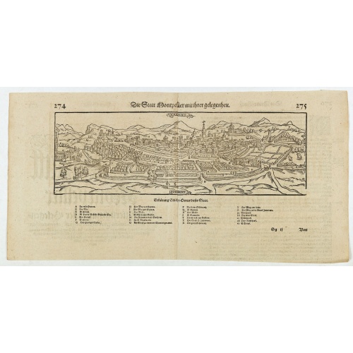
Die statt Montpellier . . .
Panoramic view of Montpellier by Sebastian Münster. Below the engraving a letterpress key. From the German edition of Sebastian Munster's Cosmography, "Cosmographey oder beschreibung aller Länder".
€75
Maker : MÜNSTER, S
Place : Basel, Heinrich Petri
Date : 1574
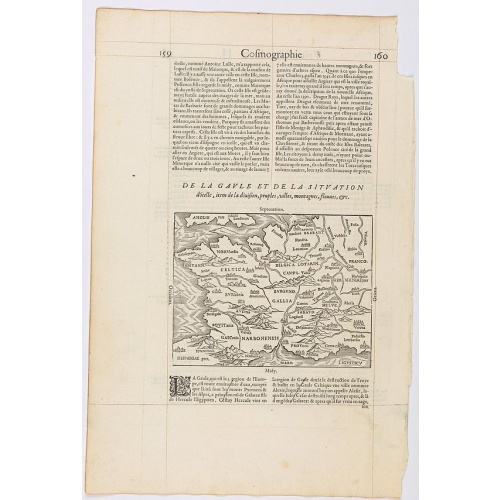
Page from La Cosmographie Universelle with map of France. (Page 160)
Text page with woodblock map of ancient France (122 x 163 mm.) In 1575 Sebastian Münster's Cosmographia was translated into French and published in Paris by François de Belle-Forest.
€75
Maker : DE BELLE-FOREST, F.
Place : Paris
Date : 1575
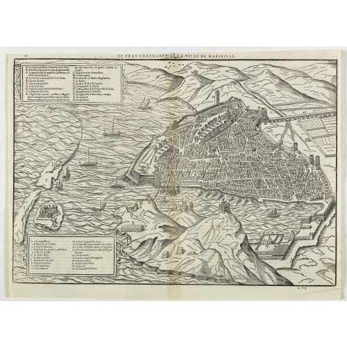
Le vray portraict de la Ville de Marseille.
Fine wood cut bird's-eye view of Marseille. Decorated with several ship in the harbour and on the sea. To the left two keys describing the main buildings and places. Published in "La Cosmographie Universelle de tout le monde", printed in 1575 in Paris by Nicolas Chesneau and Michel Sonnius with the French text by Francois de Belleforest.The book is a French version of Sebastian Münster's "Cosmographia Universalis".
€800
Maker : BELLEFOREST, F. de.
Place : Paris
Date : 1575
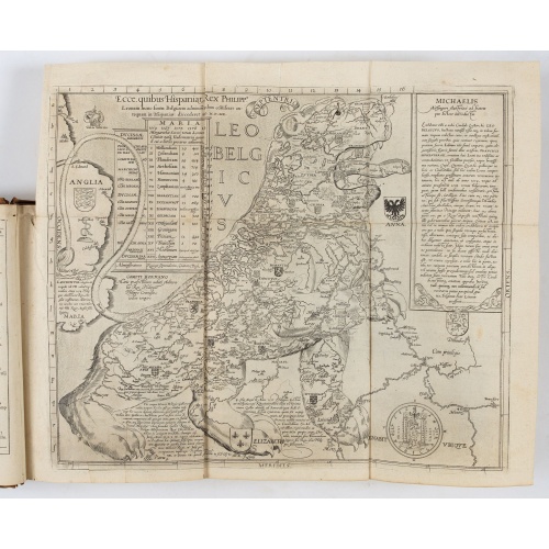
Novus de Leone Belgico eiusq topographia atq. Historica descriptione liber (…). Rerumque in Belgio maxime gestarum, inde ab anno Christi M.D.LIX. Usque ad annum M.D.LXXXVII perpetua narratione continatus.
ENLARGED EDITION, with 207 (of 208) engravings of a famous eyewitness account of the Dutch Revolt, with the famous "Leo Belgicus" map, here in its second state. One of the major sources for the history of the Low Countries during the beginning of their struggle for independence. This history of the religious wars in Belgium and Holland from 1559-87 is illustrated with Hogenberg's engravings (from his "Geschichtsblättern"), whereby the engravings for this edition were printed without the lower ...
$39.000
Maker : AITSINGER (EYZINGER), Michael von.
Place : Cologne, Gerardus Campensis for Frans Hogenberg
Date : 1588
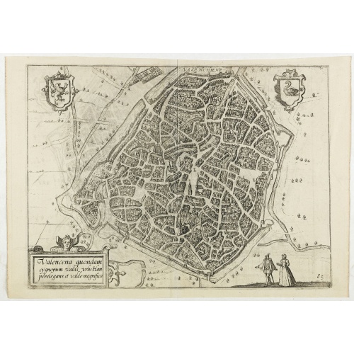
Valencena . . .
Eye-bird view of Valenciennes.
€55
Maker : GUICCIARDINI, L.
Place : Anvers
Date : 1590
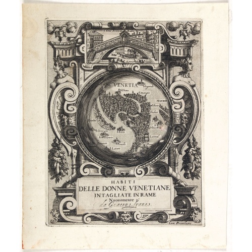
Habiti delle Donne Venetiane . . .
Title page of the book Habiti delle Donne Venetiane" (Dress of Venetian Women) which consists of twenty numbered plates of ornately dressed women. This very decorative title page shows in to Rialto Bridge and in the center a bird's-eye plan of Venice.Giacomo Franco (1556-1620) was born and grew in Venice, where he used to work. He was the son of painter Giovanni-Battista Franco (1510-1561), with whom he began his artistic training at the age of eleven. He worked as a painter, engraver, woodcutte...
€950
Maker : FRANCO, G.
Place : Venice
Date : ca. 1591
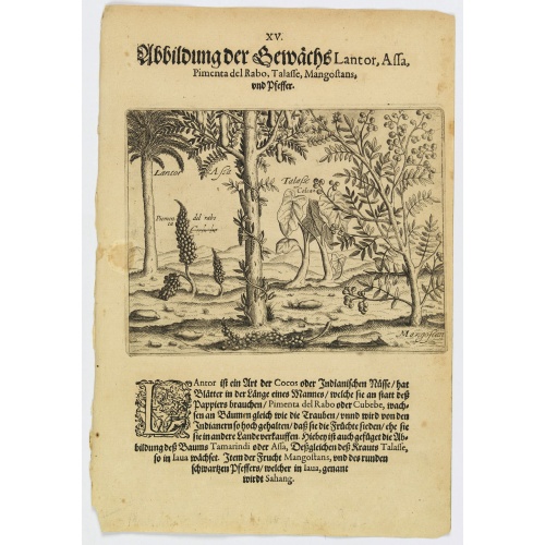
Plants Lantor, Assa, Pimenta, Mangostan and Pepper.
Lantor is a kind of coconut palm (or Indian nut) with fronds as long as a human body. These fronds are used as paper. Pimenta del Rabo (or cubebe) grows grape-like on trees and is held in such esteem by the Indians that they cook and preserve them, rather than sell them to other countries. Also shown is the Tamarind tree or Assa, the plant Talasse grows in Java, and the Mangostan fruit and the black pepper is called ‘Sahang’ in Java.Theodore de Bry, a German engraver and book dealer, began a...
€80
Maker : DE BRY, Th.
Place : Frankfurt
Date : 1598
![Venetia. [Venice ]](/uploads/cache/45176-500x500.jpg)
Venetia. [Venice ]
Very rare view of Venice published in the first edition of "Viaggio da Venetia, a Costantinopoli. Per Mare, e per Terra, & infieme quello di Terra Santa. Da Gioseppe Rosaccio con brevita descritto".Several of the maps and plans resemble those in G. F. Camocio's "Isole famose", in particular the maps of the individual Greek islands, among which are Corfu, Crete, Cyprus, together with a map of Palestine and a view of Jerusalem.It is possible that many of the plates may originate from 1590-1597, wh...
€420
Maker : ROSACCIO, Giuseppe
Place : Venice, Giacomo Franco, 1598
Date : 1598
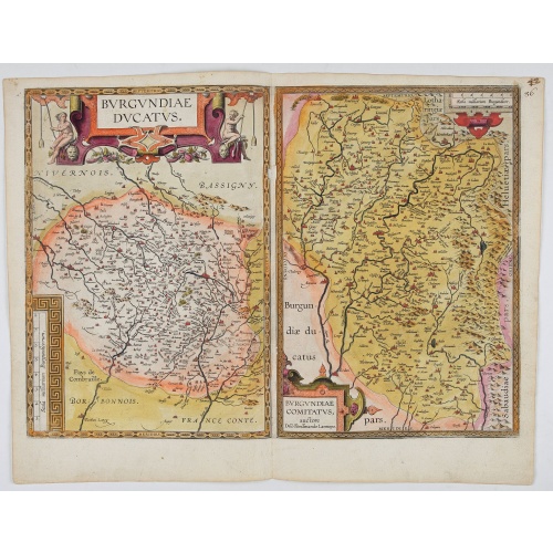
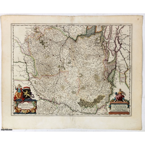
Burgundiae Ducatus. Burgundiae Comitatus.
Separately issued map of Burgundy area. Two maps of Burgundy region on a plate. Separately published map, without text on the verso. Second state with the date 1597 removed from the title cartouche. This is the rarest Burgundy map of the four that Ortelius made.
€500
Maker : ORTELIUS, A.
Place : Antwerp
Date : after 1612
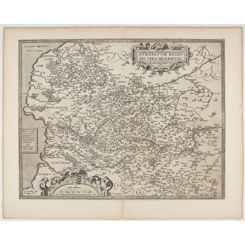
Artois. Atrebatum Regionis Vera Descripto.
Prepared by Jacob Surhon who made a manuscript map of Artois for which he received 36 Livres from Charles V in 1554. For security reasons the map was not published. Only in 1579, when Antwerp was independent for a short time, Ortelius used the map for publication in his atlas.This is the last and very rare state with the signature of Theodorus Galle.
€500
Maker : ORTELIUS, A. / GALLE, Th.
Place : Antwerp, after 1612
Date : 1612
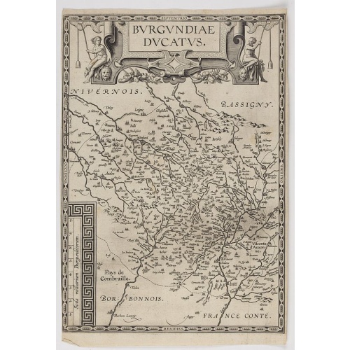
Burgundiae Ducatus.
Map of Burgundy region without text on the verso. Second state with the date 1597 removed from the title cartouche. This is the rarest Burgundy map of the four that Ortelius made.
€500
Maker : ORTELIUS, A.
Place : Antwerp
Date : after 1612
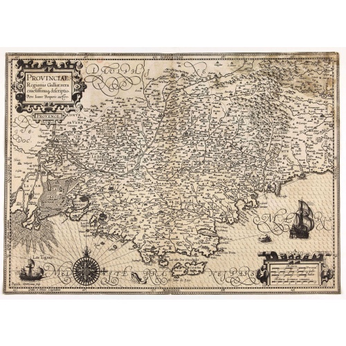
Provinciae, Regionis Galliae, vera exactissimaq. descriptio. Provence Petro Ioanne Bomparioo auctore.
A finely engraved map of the Province prepared by Pierre-Jean de Bompar who published a single sheet map of the Province in 1591. Title cartouche in the upper left-hand corner. Engraved by Baptista Doetichum.
€500
Maker : HONDIUS, J. / DOETECOM, B.
Place : Amsterdam
Date : 1613
Nieuw Nederlandtsch Caertboeck. Waer in volkomentlijcker als oyt te voren vertoont werden de XVII. Nederlanden.
Rare first edition of this atlas of the provinces of the Netherlands, Belgium and Luxemburg. Engraved title page, with : "Gedruckt t' Amsterdam by Abraham Goos Plaetsnyder wonende op den Dam in 't vergulde Caertboeck.Our atlas is conform to the copy described in Koeman/Krogt : "One copy is known of the B-edition without text (Brussel KB IV). All maps in this copy are in the second variant".A. Goos published on his own a single atlas, the " Nieuw Nederlandtsch Caertboeck" with 23 maps. He receive...
$3.000
Maker : GOOS, A.
Place : Amsterdam
Date : 1616
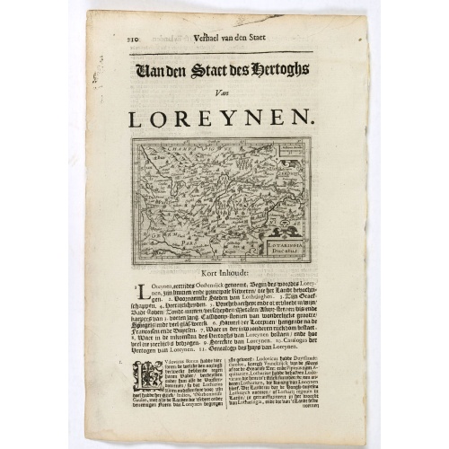
Lotaringia Ducatus.
Small map of Lorraine, oriented with West on top and surrounded by text in Dutch. Nicolaes de Clerck (de Klerc) was active as an engraver and publisher in Delft from 1599-1621.Included in the rare book : Wereld Spiegel, waer in vertoontword de Beschryvinge der Rijken Staten, ende vorstendommen des gantsen Aerdbodems… which was a Dutch translation of "Les estats, empires et principautez de monde" by Pierre Davity.The map is engraved by Jodocus Hondius before 1616 and first published in Petrus ...
€75
Maker : DE CLERCK, N.
Place : Amsterdam, Cloppenburch
Date : 1621
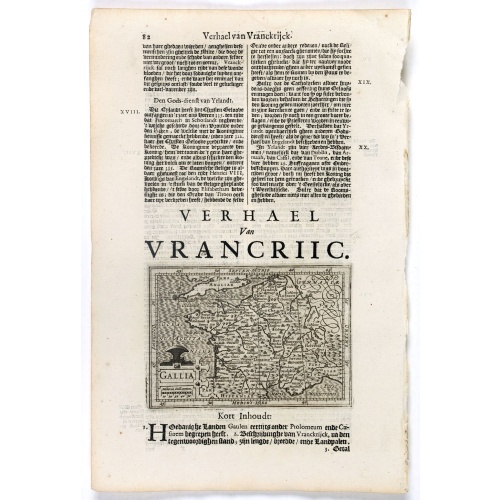
Gallia.
Small map of France, surrounded by text in Dutch. Nicolaes de Clerck (de Klerc) was active as engraver and publisher in Delft from 1599-1621.Included in the rare book : Wereld Spiegel, waer in vertoontword de Beschryvinge der Rijken Staten, ende vorstendommen des gantsen Aerdbodems… which was a Dutch translation of "Les estats, empires et principautez de monde" by Pierre Davity.The map is engraved by Jodocus Hondius before 1616 and first published in Petrus Bertius' revised pocket atlas Tab...
€70
Maker : DE CLERCK, N.
Place : Amsterdam, Cloppenburch
Date : 1621
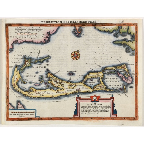
Description des Isles Bermudas.
Map of Bermuda from the rare Cloppenburg edition slightly larger format and more scarce edition of the Mercator/Hondius "Atlas Minor". Engraved by Pieter Van Den Keere.The Cloppenburg edition "Atlas Sive Cosmographicae Meditationes De Fabrica Mundi Et Fabricati Figura", was continued for a couple of years but seems to have been suppressed after 1636 ... (Koeman Atlantes Neerlandici).Based on the 1595 Abraham Ortelius map, but with added decoration.
€800
Maker : MERCATOR, G. / CLOPPENBURGH, J.E.
Place : Amsterdam
Date : 1630
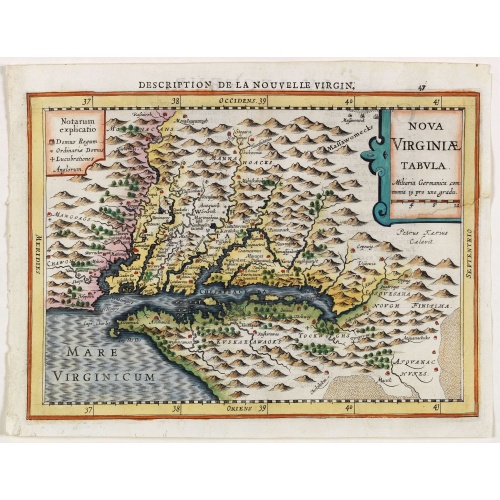
Virginiae item et Floridae . . .
Map of Virginia from the rare Cloppenburg edition slightly larger format and more scarce edition of the Mercator/Hondius "Atlas Minor". Engraved by Pieter Van Den Keere.The Cloppenburg edition "Atlas Sive Cosmographicae Meditationes De Fabrica Mundi Et Fabricati Figura", was continued for a couple of years but seems to have been suppressed after 1636 ... (Koeman Atlantes Neerlandici).Based on the 1595 Abraham Ortelius map, but with added decoration.
€750
Maker : MERCATOR, G. / CLOPPENBURGH, J.E.
Place : Amsterdam
Date : 1630
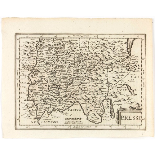
Bresse.
Early map of Eastern France and part of Switzerland. Geneva in upper right corner. With Latin text on verso. Engraved by Petrus Kaerius. Shortly after the publication of big folio-atlases the need was apparently felt for a smaller sized atlas, one that would be handier and, above all, cheaper. Joh. Cloppenburgh published in 1630 a atlas based on Mercator's pocket map, but in a slightly larger size. He published a Latin text edition in 1632.
€50
Maker : CLOPPENBURGH, J.E.
Place : Amsterdam
Date : 1632
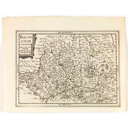
Belovacium comitatus.
Early map centered north of Paris. With Latin text on verso. Engraved by Petrus Kaerius. Shortly after the publication of big folio-atlases the need was apparently felt for a smaller sized atlas, one that would be handier and, above all, cheaper. Joh. Cloppenburgh published in 1630 a atlas based on Mercator's pocket map, but in a slightly larger size. He published a Latin text edition in 1632.
€75
Maker : CLOPPENBURGH, J.E.
Place : Amsterdam
Date : 1632