ID: 458
Open
![Parisius & Maguncia. [Paris & Munich] Folio XXXIX](/uploads/29718.jpg)
Parisius & Maguncia. [Paris & Munich] Folio XXXIX
BuyNow for €900
- Maker :
- SCHEDEL, H.
- Place :
- Nuremberg
- Date :
- 12 July 1493
- Color :
- Colored
- Height mm.:
- 360
- Width mm.:
- 230
- Condition :
- Wood cut. Some marginal minor age-toning on the outer left hand margin. Size of illustration 229 x 197mm.
- Bibliography :
- Morse Library Beloit College.
- Seller's ref. :
- 29718
This item is offered by Librairie_Loeb-Larocque
See other Items from this seller- Postage
-
France
€15 to France
- Select Country
- Zip/Post Code
- Quantity
€900
Description
Imaginary view of Paris and on verso Munich : however the earliest obtainable views of this period.In the forground a large vessel, who was the symbol of the powerful corporate body of the Marchands de l'eau, and is dating back to the Middle Ages. The city motto, "Fluctuat nec mergitur" ("It is beaten by the waves without being submerged") is equally a reference to this vessel. The first mention of coat of arms of Paris with the vessel appears as early as 1190 when Philippe Augustus gave the design to the city, shortly before embarking to the Holy Land.
Page from the richest illustrated Incunabel, the famous: Liber chronicarum or Nuremberg Chronicle, published the year that Columbus returned to Europe after discovering America.
The woodblock cutters were Michael Wolgemut, the well-known teacher of Albrecht Dürer, and his stepson Wilhelm Pleydenwurff. Wohlgemut was Albrecht Dürer's tutor between 1486-90 and recent scholarship has shown, Albrecht Dürer may also have collaborated, since some of the cuts bear a remarkably close resemblance to the Apocalypse illustrations.
The printing was carried out under the supervision of the great scholar-printer Anton Koberger, whose printing were famous throughout Europe.
A opportunity to acquire a 15th-century book illustration by named artists.!
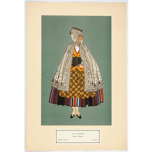
Femme de Barèges (106, La Gascogne).
Plate published in "Les costumes régionaux de France" with illustrations by Gratiane de Gardilanne (painter and designer) and Elisabeth Whitney Moffat.Costume plate printed in collotype, pochoir and retouched by hand. Dimension of 24.5 x 38cm. The originals were donated by an American patron to the Metropolitan Museum of Art in New York and constitute a set of 200 plates. Good condition.
€75
Maker : GARDILANNE (G.de) et MOFFAT (E.W.)
Place : Paris, Editions du Pégase, 1929
Date : 1929
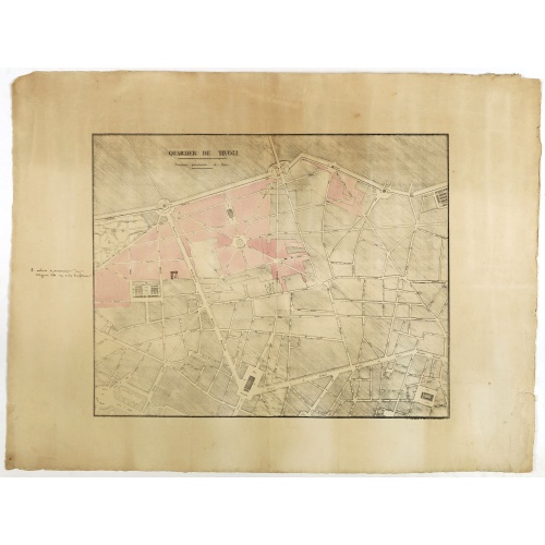
Quartier de Tivoli Nouveaux pereements de Rues.
Plan of the center of Paris showing Tivoli district with Madalene and Clichy. Lithography and pen and ink. Drawn in are the planned workshop of Serrurerie Théophile Mignon, 30 rue de la Bienfaisance.
€75
Maker : ANNONYMOUS
Place : Paris
Date : ca.1835
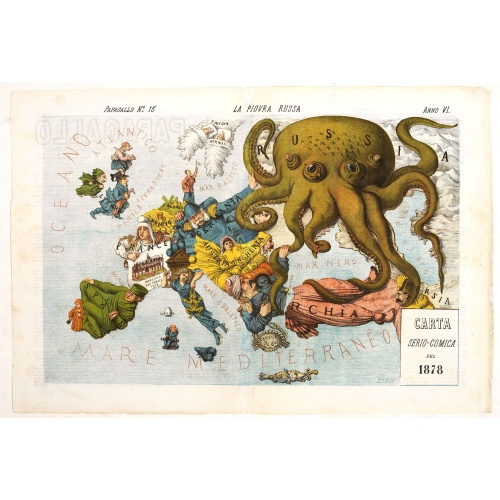
La Piovra Russa. Carta Serio-Comica Pel 1878.
Very rare political caricature map by Grossi of the nations of Europe, published in Bologna in the supplement of the newspaper "Le Perroquet / Al papagallo, N° 15, Anno VI.Known as the Octopus Map ; the brooding presence of the Russian Empire depicted as a massive octopus, whose tentacles stretch out towards Europe. In this map, the Octopus has Turkey, Persia and Poland but has been wounded by Crimea and is being fought off by Germany.This map, by Grossi, followed the style created by Frederick...
€1.850
Maker : GROSSI, A.
Place : Bologne
Date : 14 avril 1878

Partie du Mexique ou de la Nouvelle Espagne Où se trouve l'Audience de Guatimala.
Nice small map of Central America, extending from the Yucatán Peninsula to Panama. From Atlas Portatif Universel, by Robert de Vaugondy.From Atlas Portatif Universel, by Robert de Vaugondy.Page 89 outside border top right. Mary Sponberg Pedley does not mention a state with this number.
€50
Maker : VAUGONDY, R. de
Place : Paris
Date : later than 1749
Postage & Shipping
-
Item Location
Terms and conditions - Item Location
- 75013, Ile-de-France, France
- Ships To
- United States, United Kingdom, Albania, Argentina, Armenia, Australia, Austria, Bahamas, Belgium, Bermuda, Bosnia and Herzegowina, Brazil, Bulgaria, Canada, Chile, China, Costa Rica, Denmark, Dominica, Egypt, El Salvador, Finland, France, Germany, Greece, Guatemala, Hong Kong, Hungary, Iceland, India, Italy, Japan, Korea (South), Kuwait, Liechtenstein, Lithuania, Luxembourg, Madagascar, Mexico, Monaco, Morocco, Netherlands, Netherlands Antilles, New Zealand, Norway, Paraguay, Peru, Philippines, Poland, Portugal, Qatar, Reunion, Romania, San Marino, Saudi Arabia, Seychelles, Singapore, Slovenia, South Africa, Spain, Sri Lanka, Suriname, Sweden, Switzerland, Taiwan, Thailand, Tunisia, Turkey, United Arab Emirates, Uruguay, Vietnam
- Pick-ups
- Buyer can pick-up
This item is owned and offered by the seller Librairie_Loeb-Larocque - All items are available for immediate sale, offered subject to prior sale.
Invoices are created by the seller by using our shopping cart or be prepared by the seller the day following the order and are emailed to you.
Items offeres by different sellers are invoiced separately.
Shipping fees are extra. The buyer is responsible for all applicable taxes, including any VAT, customs clearance, import duties, or equivalent costs arriving at the customer's home border. Payment is due on receipt of the invoice. The item(s) are shipped as soon as possible after receipt of your payment.
Before buying please read the complete Terms Conditions of Sale.
- Payment Methods
- Visa, Mastercard, Bank Transfer, American Express, iDEAL, PayPal, Google Pay
- Returns Accepted
- No
Post Message
Feel free to ask the seller a question. Please note that the seller could be located in an area with a different time zone. Our seller will do their best to respond within 24 hours.Post your message below.
Sign in to ask the seller a question.
![Parisius & Maguncia. [Paris & Munich] Folio XXXIX](/uploads/cache/29718-500x500.jpg)