ID: 349
Open
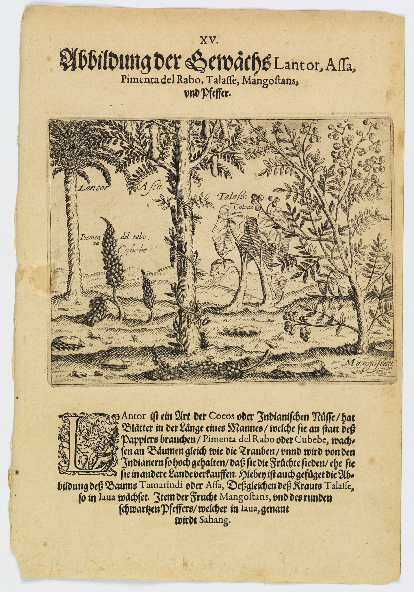
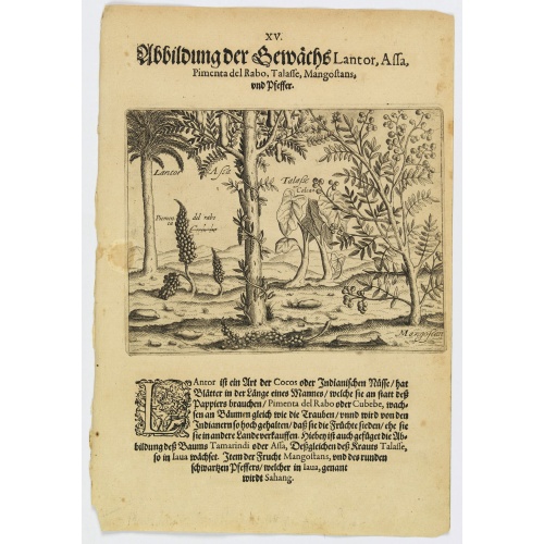
Plants Lantor, Assa, Pimenta, Mangostan and Pepper.
BuyNow for €80
- Maker :
- DE BRY, Th.
- Place :
- Frankfurt
- Date :
- 1598
- Color :
- Uncoloured
- Height mm.:
- 135
- Width mm.:
- 175
- Condition :
- Copper plate engraving on text sheet. Paper lightly browned and spotted as usual. Size of sheet : 290 x 200 mm. German text.
- Bibliography :
- www.history-engraved.org/Java 152
- Seller's ref. :
- 41370
This item is offered by Librairie_Loeb-Larocque
See other Items from this seller- Postage
-
France
€15 to France
- Select Country
- Zip/Post Code
- Quantity
€80
Description
Lantor is a kind of coconut palm (or Indian nut) with fronds as long as a human body. These fronds are used as paper. Pimenta del Rabo (or cubebe) grows grape-like on trees and is held in such esteem by the Indians that they cook and preserve them, rather than sell them to other countries. Also shown is the Tamarind tree or Assa, the plant Talasse grows in Java, and the Mangostan fruit and the black pepper is called ‘Sahang’ in Java.Theodore de Bry, a German engraver and book dealer, began a compilation of early voyages in 1590 and had published six parts at the time of his death in 1598. His widow, two sons, and another family member continued the work, which comprised a total of fifty-four parts when it was completed in 1630. The publication is in two series, denoted the Grands Voyages and the Petit Voyages. A German edition of the Petit Voyages was published in 1599 in Frankfurt am Main. A second German edition came out in 1616. Latin editions were published in 1609 and 1629.

West India Islands.
Map of the West Indies, published by "The London Printing and Publishing Company". Drawn and engraved by John Rapkin.
€75
Maker : RAPKIN, J.
Place : London
Date : 1854
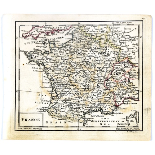
France.
Uncommon miniature map of France, engraved by J.Spilbury for "A New General and Universal Atlas Containing Forty five Maps by Andrew Dury".This miniature atlas published during the Seven Years' War.The maps are typical for the period and well executed with great clarity. The plates are engraved in 1761 and in 1763 a second edition was presumably produced for the French market having all but nine with a French titles added above the top.
€50
Maker : DURY, A. / SAYER, R. / KITCHIN, T.
Place : London
Date : 1761-1763
![Parisius & Maguncia. [Paris & Munich] Folio XXXIX](/uploads/cache/29718-500x500.jpg)
Parisius & Maguncia. [Paris & Munich] Folio XXXIX
Imaginary view of Paris and on verso Munich : however the earliest obtainable views of this period.In the forground a large vessel, who was the symbol of the powerful corporate body of the Marchands de l'eau, and is dating back to the Middle Ages. The city motto, "Fluctuat nec mergitur" ("It is beaten by the waves without being submerged") is equally a reference to this vessel. The first mention of coat of arms of Paris with the vessel appears as early as 1190 when Philippe Augustus gave the des...
€900
Maker : SCHEDEL, H.
Place : Nuremberg
Date : 12 July 1493
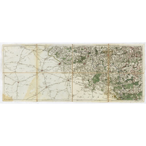
Les environs de Mons, Beaumont, Chimay, Valenciennes, Condé, &c.
Detailed map of Northern France, centered on Valenciennes and Mons. The map was prepared by Jean Baptiste de Bouge (1757-1833), who prepared one of the first very detailed maps of Belgium.Map 9 of a large wall map of Belgium.
€50
Maker : DE BOUGE, J-B.
Place : Bruxelles
Date : 1789 - 1793
Postage & Shipping
-
Item Location
Terms and conditions - Item Location
- 75013, Ile-de-France, France
- Ships To
- United States, United Kingdom, Albania, Argentina, Armenia, Australia, Austria, Bahamas, Belgium, Bermuda, Bosnia and Herzegowina, Brazil, Bulgaria, Canada, Chile, China, Costa Rica, Denmark, Dominica, Egypt, El Salvador, Finland, France, Germany, Greece, Guatemala, Hong Kong, Hungary, Iceland, India, Italy, Japan, Korea (South), Kuwait, Liechtenstein, Lithuania, Luxembourg, Madagascar, Mexico, Monaco, Morocco, Netherlands, Netherlands Antilles, New Zealand, Norway, Paraguay, Peru, Philippines, Poland, Portugal, Qatar, Reunion, Romania, San Marino, Saudi Arabia, Seychelles, Singapore, Slovenia, South Africa, Spain, Sri Lanka, Suriname, Sweden, Switzerland, Taiwan, Thailand, Tunisia, Turkey, United Arab Emirates, Uruguay, Vietnam
- Pick-ups
- No pick-ups
This item is owned and offered by the seller Librairie_Loeb-Larocque - All items are available for immediate sale, offered subject to prior sale.
Invoices are created by the seller by using our shopping cart or be prepared by the seller the day following the order and are emailed to you.
Items offeres by different sellers are invoiced separately.
Shipping fees are extra. The buyer is responsible for all applicable taxes, including any VAT, customs clearance, import duties, or equivalent costs arriving at the customer's home border. Payment is due on receipt of the invoice. The item(s) are shipped as soon as possible after receipt of your payment.
Before buying please read the complete Terms Conditions of Sale.
- Payment Methods
- Visa, Mastercard, Bank Transfer, American Express, iDEAL, PayPal, Google Pay
- Returns Accepted
- No
Post Message
Feel free to ask the seller a question. Please note that the seller could be located in an area with a different time zone. Our seller will do their best to respond within 24 hours.Post your message below.
Sign in to ask the seller a question.