ID: 132
Open
Listing ID: #132 has been added to your wishlist.
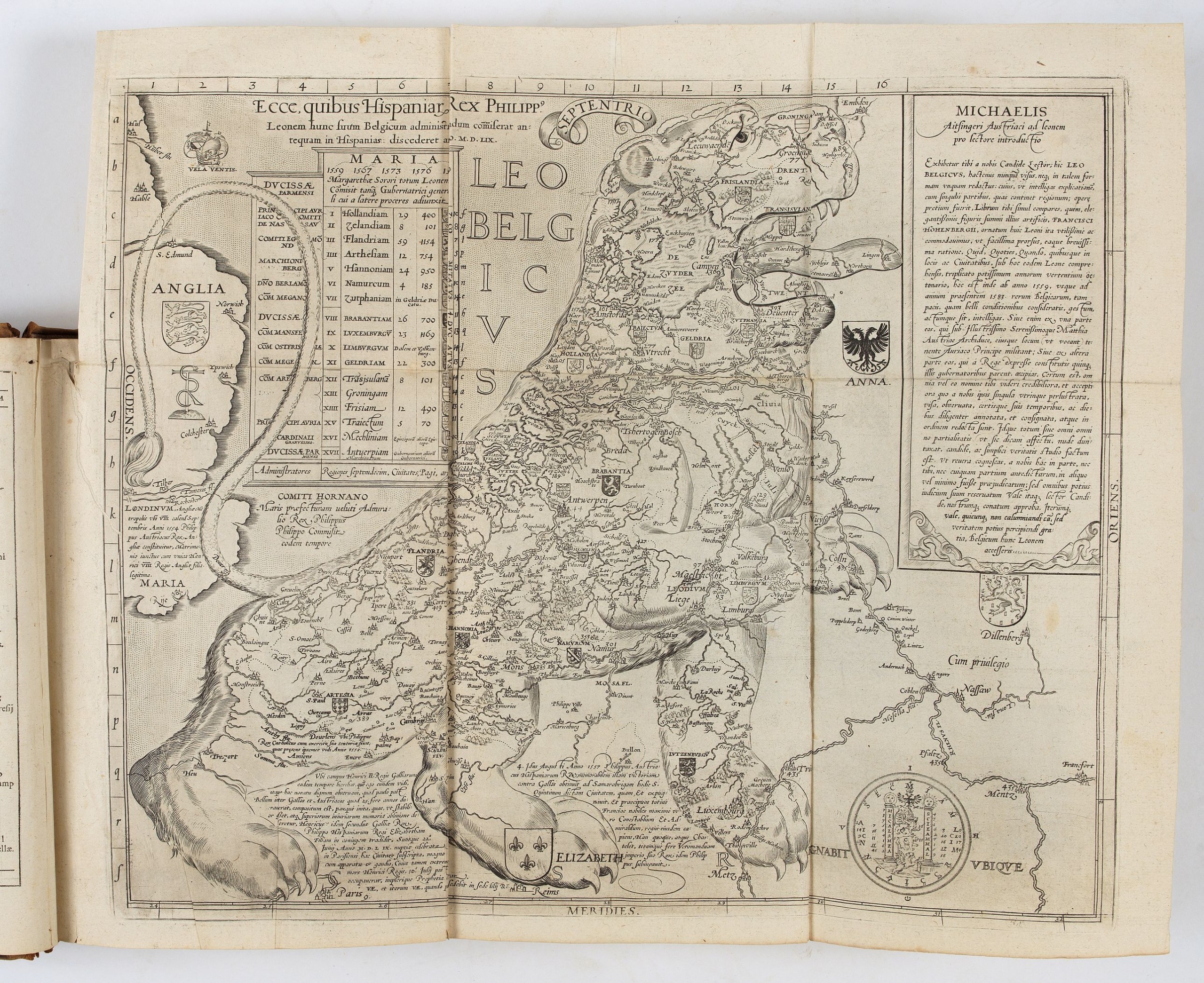
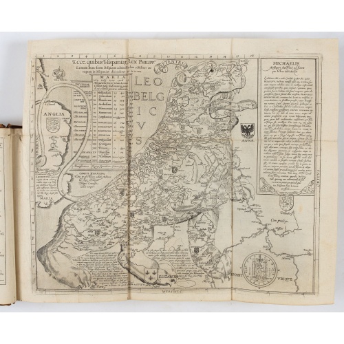
Novus de Leone Belgico eiusq topographia atq. Historica descriptione liber (…). Rerumque in Belgio maxime gestarum, inde ab anno Christi M.D.LIX. Usque ad annum M.D.LXXXVII perpetua narratione continatus.
BuyNow for $39.000
- Maker :
- AITSINGER (EYZINGER), Michael von.
- Place :
- Cologne, Gerardus Campensis for Frans Hogenberg
- Date :
- 1588
- Color :
- Uncoloured
- Height mm.:
- 276
- Width mm.:
- 204
- Condition :
- Folio. With the famous large folding engraved map "Leo Belgicus", engraved title page, portrait of von Aitsingzer, 207 (of 208) double-page engravings, 430pp. Apparently there are at least two different editions from 1588 with different contents. Contempo
- Bibliography :
- VdHeijden, Leo Belgicus 1.2.
- Seller's ref. :
- 48778
This item is offered by Librairie_Loeb-Larocque
See other Items from this seller- Postage
-
Standard Shipping
$0 to France
- Select Country
- Zip/Post Code
- Quantity
$39.000
Description
ENLARGED EDITION, with 207 (of 208) engravings of a famous eyewitness account of the Dutch Revolt, with the famous "Leo Belgicus" map, here in its second state. One of the major sources for the history of the Low Countries during the beginning of their struggle for independence. This history of the religious wars in Belgium and Holland from 1559-87 is illustrated with Hogenberg's engravings (from his "Geschichtsblättern"), whereby the engravings for this edition were printed without the lower text panel and have Latin text on the reverse. They mostly show siege scenes of the most important cities in the Netherlands, e.g. Alkmaar, Amsterdam, Antwerp, Bergen op Zoom, Breda, Brussels, Haarlem, Leiden, Maastricht, Mechelen, Middelburg, Rotterdam, Utrecht, Zuthphen and some from France.The Australian author Michael Aitsinger (1530 ?-1598 ?) followed the tradition of 'newsletters' published on the occasion of the regular trade-fairs, began to issue a series of half-yearly publications. This work, written with unusual impartiality for the time, was repeatedly updated and reprinted. Aitsinger witnessed the execution of Egmont and Hoorn and became a partisan historian of the Dutch Revolt. The fame of the book owes much to the 208 fine engravings by Frans Hogenberg (1536-1590) which depict many places and historical events in the Netherlands and Germany with great reliability.
The splendid "Leo Belgicus" i.e. folding engr. map of the Low Countries as a lion became a symbol of the unity and strength of the 17 Provinces was the prototype for numerous similar maps up to the beginning of the 19th century, is here present in its second state with the name of Elisabeth (of Valois) added.

L'Europe en Sept 1939. Ille terrarum mihi angulus ridet.
A rare oversized serio-comic map of Europe at the start of the Second World War depicting stereotypes of 31 countries, as listed in the key lower right, including Britain as a woman with battleships on leads; France as Marianne, leading her troops into battle; Germany, with a swastika sash, stabbing a female Poland; and Russia as a Cossack holding a hammer and sickle, his arm around a large brown bear. Very scarce, although as mentioned on the map 150 were printed, only three, nos. 8, 9, 10, 13...
€9.000
Maker : VLAANDEREN, Cornelis André
Place : Bruges, Leon Burghgraeve
Date : 1939
Le Indie Ocidentali ( Antille maggiori e minori, ecc) L'America Centrale . . .
Uncommon map of Central America and the Antilles prepared by Francesco Costantino Marmocchi. Above the map "Geografia Commerciale". From "Il Globo Atlante di carte Geografiche compilate da F.C. Marmocchi per servire di corredo al suu corso di geografia commerciale", with the maps engraved by engraved by Gius. Cattaneo, Campo Antico, C. Poggiali, G. Bonatti, and Ces. Magrini.Marmocchi (Poggibonsi, 1805-Geneva, 1858) was known as a geographer and cartographer. He emigrated to Rome, and later to Co...
€75
Maker : MARMOCCHI, F.C.
Place : Genova, Paolo Rivara fu Giacomo
Date : 1858
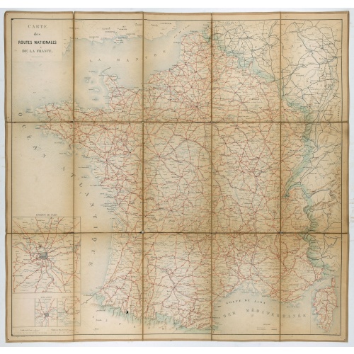
Carte nationale des routes de la France.
Map of the national roads in France, engraved and published by Regnier et Dourdet. Four inset maps of which three shows the three largest cities in France and one shows Corsica.
€75
Maker : REGNIER ET DOURDET
Place : Paris
Date : ca. 1900
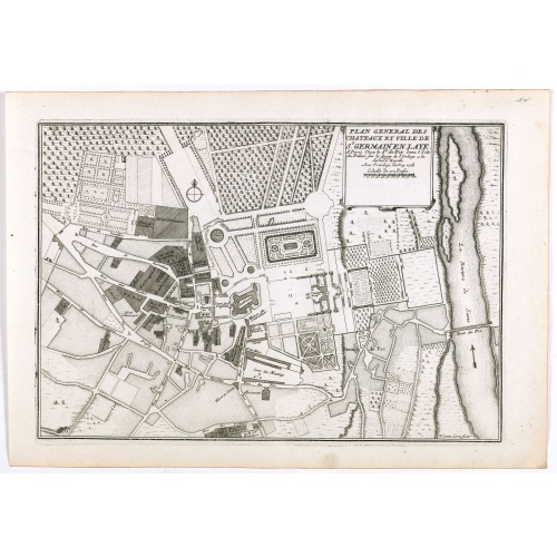
Plan general des chateaux et ville de St Germain en Laye.
City plan of St Germain en Laye, from Nicolas de Fer's "L'Atlas curieux ou le Monde réprésente dans des cartes. "The "Atlas Curieux" is a geographic encyclopedia of images and a celebration of the French Empire under the Sun King, with maps of French possessions in the western hemisphere, maps of France, with detailed views of the grand waterworks at Marly, views of the great palaces and chateaux, views and plans of the Paris Observatory, and samples of military architecture. Issued in six ann...
€60
Maker : DE FER, N.
Place : Paris
Date : 1705
Postage & Shipping
-
Item Location
Terms and conditions - Item Location
- 75013, Ile-de-France, France
- Ships To
- United States, United Kingdom, Albania, Argentina, Armenia, Australia, Austria, Bahamas, Belgium, Bermuda, Bosnia and Herzegowina, Brazil, Bulgaria, Canada, Chile, China, Costa Rica, Denmark, Dominica, Egypt, El Salvador, Finland, France, Germany, Greece, Guatemala, Hong Kong, Hungary, Iceland, India, Italy, Japan, Korea (South), Kuwait, Liechtenstein, Lithuania, Luxembourg, Madagascar, Mexico, Monaco, Morocco, Netherlands, Netherlands Antilles, New Zealand, Norway, Paraguay, Peru, Philippines, Poland, Portugal, Qatar, Reunion, Romania, San Marino, Saudi Arabia, Seychelles, Singapore, Slovenia, South Africa, Spain, Sri Lanka, Suriname, Sweden, Switzerland, Taiwan, Thailand, Tunisia, Turkey, United Arab Emirates, Uruguay, Vietnam
- Pick-ups
- Buyer can pick-up
This item is owned and offered by the seller Librairie_Loeb-Larocque - All items are available for immediate sale, offered subject to prior sale.
Invoices are created by the seller by using our shopping cart or be prepared by the seller the day following the order and are emailed to you.
Items offeres by different sellers are invoiced separately.
Shipping fees are extra. The buyer is responsible for all applicable taxes, including any VAT, customs clearance, import duties, or equivalent costs arriving at the customer's home border. Payment is due on receipt of the invoice. The item(s) are shipped as soon as possible after receipt of your payment.
Before buying please read the complete Terms Conditions of Sale.
- Payment Methods
- Visa, Mastercard, Bank Transfer, American Express, iDEAL, PayPal, Google Pay
- Returns Accepted
- No
Post Message
Feel free to ask the seller a question. Please note that the seller could be located in an area with a different time zone. Our seller will do their best to respond within 24 hours.Post your message below.
Sign in to ask the seller a question.