
ID: 130
Open
Listing ID: #130 has been added to your wishlist.

L'Europe en Sept 1939. Ille terrarum mihi angulus ridet.
BuyNow for €9.000
- Maker :
- VLAANDEREN, Cornelis André
- Place :
- Bruges, Leon Burghgraeve
- Date :
- 1939
- Color :
- Color printed, with hand color
- Height mm.:
- 615
- Width mm.:
- 855
- Condition :
- Chromolithograph with hand color. With a small repaired split in the upper left corner. No 17 of a limited edition of 150. Accompanied by an explanatory text sheet in French
- Bibliography :
- Roderick M. Barron, 'Bringing the map to life: European satirical maps 1845-1945', Belgeo [Online], 3-4 | 2008, Online on 06 August 2014, Accessed 29 December 2021.
- Seller's ref. :
- 48319
This item is offered by Librairie_Loeb-Larocque
See other Items from this seller- Postage
-
Standard Shipping
€0 to France
- Select Country
- Zip/Post Code
- Quantity
€9.000
Description
A rare oversized serio-comic map of Europe at the start of the Second World War depicting stereotypes of 31 countries, as listed in the key lower right, including Britain as a woman with battleships on leads; France as Marianne, leading her troops into battle; Germany, with a swastika sash, stabbing a female Poland; and Russia as a Cossack holding a hammer and sickle, his arm around a large brown bear.
Very scarce, although as mentioned on the map 150 were printed, only three, nos. 8, 9, 10, 13 and 17 (this example), are known to have survived.
Around the title is a vignette of a skeleton, helmeted and armed with his bloody scythe, carrying a war torch. A floating ribbon bears as a motto a citation from Horace 'Ille terrarium mihi angulus ridet' (this corner of ground smiles at me), a device with a double symbolic meaning, that goes as well with this part of Europe, chosen by Mars as his field of activity, as Poland which, desired by both Germany and Russia, was the origin of the worldwide catastrophe.
Cornelis André Vlaanderen (1881-1955), was a Dutch graphic artist and typographer, who specialized in book illustrations, bookplates and posters.In 1905 to open his own business and began designing advertising for the Gazelle Rijwielfabriek (a bicycle manufacturer) not long afterward. It is estimated that he created at least 500 advertisements for Gazelle between 1914 and 1929. Vlaanderen moved to Belgium in August 1929. He first settled in Ghent and in August 1930 moved to the suburbs of Bruges (Brugge). He lived in Bruges from 1939 until his death.
Accompanied by an explanatory text sheet in French and translates into English, as follows:
In the middle, the German ogre (3) is represented by Blue Beard, helmeted and wearing a strap bearing the swastika. The tyrant, having already assassinated two women Austria (5) and Czechoslovakia (4), stabs Poland (6) with his left hand. A fluttering sleeve of her blouse simulates the 'corridor'; close by, The Free City of Danzig, is marked in red. With his right hand Blue Beard brandishes a sharpened blade to the west, where Marianne (2) the French virgin, styled with a Phrygian cap, commands her troops. To the right of the enemy, the head of a murdered Jew is wedged, and we glimpse an English airplane that drops propaganda leaflets over the country. Great Britain (1) is symbolized by Dame Albion, directing her fleet, with her bag overflowing with reinforcements. The Hebrides and Shetland Islands are indicated by airplanes. To the northeast, the Finnish reindeer herder (12) watches with discontent brutal Russia (7), who, leaning on his bear, tramples embarrassed and bloody Poland; in the background, the towers of Red Square in Moscow are seen. The three little Baltic states: Lithuania (9), Latvia (10), and Estonia (11), observe in terror the colossus, armed with a hammer and a bloody sickle and ask themselves what fate is reserved for them.
Spain (20), is represented by a bullfighter, who doesn't have the time to concern himself with European affairs since he must devote all his attention to repairing his holed red cape; behind him, we see his still devastated country in ruins. At its southern tip, at Gibraltar, emerges the British cannon, that protects the approaches to the Mediterranean. Portugal (21), nestled in the folds of his national flag, makes eyes at Dame Albion and at Marianne.
Follow the other neutrals: a Dutch soldier (16) in front of his flag, aims at a plane, that passes over his territory. Belgium (17) also posed as a sentinel, is ready to defend his three-color flag and his neutrality.
No. 18 designates Luxembourg and No. 19 represents the Swiss cross. In the north, Norway and Sweden are symbolized by guard dogs, held on leash and with their collars in national colors. The Danish (15) still smokes his pipe without losing sight of everything happening below him.
In the south, Greece (27) is represented by Athena (Minerva) posted in front of Ionic columns, armed with a lance and wearing a helmet ornamented with feathers.
No. 31 shows us Turkey, sitting on his Smyrna rug and savoring his hookah, while he raises his eyes toward what is going on higher up. Behind him the crescent and sickle shine on a red background.
Finally we notice again the coast of North Africa with Morocco (28) - of which Spanish Morocco is delineated -, Algeria (29), and Tunisia (30). The illustrated title of this historic document shows Death, helmeted and armed with his bloody scythe, carrying a war torch. A floating ribbon bears as a motto a citation from Horace 'Ille terrarium mihi angulus ridet' (this corner of ground smiles at me), a device with a double symbolic meaning, that goes as well with this part of Europe, chosen by Mars as his field of activity, as Poland which, desired by both Germany and Russia, was the origin of the worldwide catastrophe.
André Vlaanderen
Painter-illustrator
23 Quai du Miroir
Bruges
More about cartographical curiosities and War Maps & Propaganda and Pictorial Maps [+]
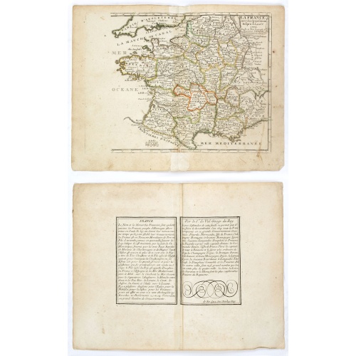
La France avec ses acquisitions jusqu'à l'année 1705.
An interesting small map of France by Nicolas de Fer. From his rare "Petit et Nouveau Atlas". The first edition was published in 1697 and was republished in 1705 and 1723. The finely engraved map is dated 1705 and was engraved by C. Inselin, the same engraver who engraved the maps in de Fer's later Atlas Curieux, published 1700-1705.
€75
Maker : DE FER, N.
Place : Paris
Date : 1705
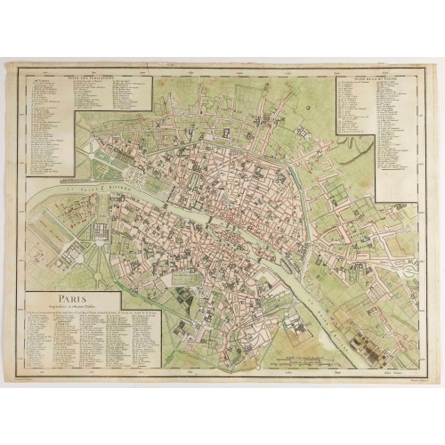
Paris Superficie 5,280,000 Toises.
FIRST EDITION of this finely engraved plan of Paris by P. F. Tardieu and prepared by DuBuisson. This detailed plan of Paris includes la Place Louis XV, la Bastille, but does not have the city walls. The first edition was included in " l'Atlas nouveau" of E. Mentelle. The second state (after 1792) has the text "Plan routier de la ville de Paris…", in the righthand lettered key, added.
€600
Maker : TARDIEU, P. F.
Place : Paris
Date : 1779-1782
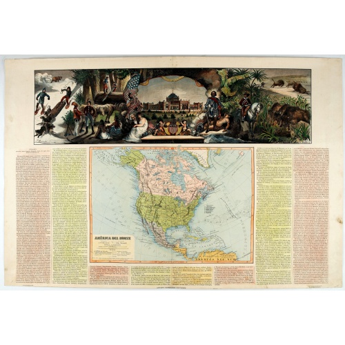
América del Norte.
Very attractive large map of North America with stunning panorama at top of figures representing the continents, etc. A rare and decorative map. From "Atlas geográfico universal texto redactado bajo la dirección de Dr. D. Juan Vilanova parte artística bajo la dirección de Otto Neussel Dibº geogrº J.P. Morales, cromo litogrº Ginés Ruiz".Good hand color on panorama and original lithographic color on the map. The most ambitious of all the monographs and scientific works by Spanish geographe...
€550
Maker : ASTORT HERMANOS EDITORES
Place : Madrid
Date : 1877

Mappa geographica Provinciæ Nova Eboraci ab Anglis New-York . . .
Lower part of the two sheets map of Homann Heirs' edition of Sauthier's celebrated map of New York and New Jersey, made during the Revolutionary War. Appears in Homann's Atlas geographicvs maior. 1759-[1784].
€750
Maker : HOMANN HEIRS.
Place : Nuremburg
Date : 1778
Postage & Shipping
-
Item Location
Terms and conditions - Item Location
- 75013, Ile-de-France, France
- Ships To
- United States, United Kingdom, Albania, Argentina, Armenia, Australia, Austria, Bahamas, Belgium, Bermuda, Bosnia and Herzegowina, Brazil, Bulgaria, Canada, Chile, China, Costa Rica, Denmark, Dominica, Egypt, El Salvador, Finland, France, Germany, Greece, Guatemala, Hong Kong, Hungary, Iceland, India, Italy, Japan, Korea (South), Kuwait, Liechtenstein, Lithuania, Luxembourg, Madagascar, Mexico, Monaco, Morocco, Netherlands, Netherlands Antilles, New Zealand, Norway, Paraguay, Peru, Philippines, Poland, Portugal, Qatar, Reunion, Romania, San Marino, Saudi Arabia, Seychelles, Singapore, Slovenia, South Africa, Spain, Sri Lanka, Suriname, Sweden, Switzerland, Taiwan, Thailand, Tunisia, Turkey, United Arab Emirates, Uruguay, Vietnam
- Pick-ups
- Buyer can pick-up
This item is owned and offered by the seller Librairie_Loeb-Larocque - All items are available for immediate sale, offered subject to prior sale.
Invoices are created by the seller by using our shopping cart or be prepared by the seller the day following the order and are emailed to you.
Items offeres by different sellers are invoiced separately.
Shipping fees are extra. The buyer is responsible for all applicable taxes, including any VAT, customs clearance, import duties, or equivalent costs arriving at the customer's home border. Payment is due on receipt of the invoice. The item(s) are shipped as soon as possible after receipt of your payment.
Before buying please read the complete Terms Conditions of Sale.
- Payment Methods
- Visa, Mastercard, Bank Transfer, American Express, iDEAL, PayPal, Google Pay
- Returns Accepted
- No
Post Message
Feel free to ask the seller a question. Please note that the seller could be located in an area with a different time zone. Our seller will do their best to respond within 24 hours.Post your message below.
Sign in to ask the seller a question.
