
ID: 361
Open
Listing ID: #361 has been added to your wishlist.
![A Map of the United States and Canada, New-Scotland, New-Brunswick and New-Foundland ... [together with] A Map of the West-Indies and of the Mexican-Gulph...](/uploads/39235.jpg)
![A Map of the United States and Canada, New-Scotland, New-Brunswick and New-Foundland ... [together with] A Map of the West-Indies and of the Mexican-Gulph...](/uploads/39235C.jpg)
A Map of the United States and Canada, New-Scotland, New-Brunswick and New-Foundland ... [together with] A Map of the West-Indies and of the Mexican-Gulph...
BuyNow for €5.000
- Maker :
- P.A.F. TARDIEU
- Place :
- Paris
- Date :
- 1806
- Color :
- In original outline colors
- Height mm.:
- 880
- Width mm.:
- 758
- Condition :
- Two maps, each map segmented and laid on cartographic linen, as issued. (530 x 800mm.). Together forming a wall map of 880 x 758mm. Each map dissected in 18 parts and with the engraved label of Ch.Picquet on the verso with title in lead pencil. Both maps
- Bibliography :
- -
- Seller's ref. :
- 39235
This item is offered by Librairie_Loeb-Larocque
See other Items from this seller- Postage
-
Standard Shipping
€0 to France
- Select Country
- Zip/Post Code
- Quantity
€5.000
Description
A Map of the United States and Canada, New-Scotland, New-Brunswick and New-Foundland / Carte des Etats Unis, avec Le Canada, la Nouvelle Ecosse, le Nouveau Brunswick & Terre-Neuve. Dressée par LAPIE, Capitaine-Ingénieur-Géographe. Publiée par P.A.F.TARDIEU, Graveur, Editeur propriétaire a Paris. Déposée à la Bibliothèque Imperiale, le 10 Juin 1806.[together with]
A Map of the West-Indies and of the Mexican-Gulph / Carte des Indes Occidentales et du Golfe du Mexique. Dressée par LAPIE, Capitaine-Ingénieur-Géographe. Publiée par P.A.F.TARDIEU, Graveur, Editeur propriétaire a Paris. Déposée à la Bibliothèque Imperiale, le 5 Septembere 1806.
[together with]
Its original case, made from boards covered with marbled paper and label.
Two maps, each map segmented and laid on cartographic linen, as issued. (530 x 800mm.) dissected in 18 parts and with the engraved label of Ch. Picquet on the verso with title in lead pencil. Both maps have signs of water staining. Together with contemp. marbled case with label “INDIES / OCCIDENT”, case is used.The norther part published in June (first state of 2, later state dates September) the lower part dated September.
This beautiful and rare set of two maps drawn by Pierre Lapie, a Colonel in the Imperial Corps of Engineers, issued by J.A. Dezauche in 1806 is largely based on the work of Aaron Arrowsmith, who first published his monumental map of North America in 1796, the current map shows the United States at a time of great transition, just after the acquisition of the Louisiana Territory, but before the extent of the western discoveries of Lewis and Clark during their exploring expedition of 1804, 1805, 1806, and those of Zebulon Pike of 1806 and 1807 is known.
Mississippi and Georgia Territories are shown, and are still inhabited by the Creek and Chactaw Indians. New Mexico is clearly shown as the property of French. The map extends to the northern coastline of South America, and includes detailed mapping of the West Indies and the Caribbean.
Remarkably fine engraving, as is characteristic of Tardieu's maps. The map was apparently issued both as a separate map of just the United States and also in a pairing with a map of the Caribbean and Central America, bringing the size to 35 x 30 inches.
This extremely rare large-scale map of the Gulf of Mexico shows the European possessions through a color-coded key adjacent to the title cartouche. The regions and islands controlled by the French, Spanish, British, Danish, Dutch, and Swedish are shown, along with the area belonging to the United States. The map was issued shortly after the Louisiana Purchase (1803), the creation of Mississippi Territory (1804) and the creation of Michigan Territory (1805) and is among the earliest printed maps to illustrate these features.
Florida is divided into East and West, and extends to the Mississippi River. There is great topographical detail throughout, and rivers and place names fill the map.
East Florida
A detail from the 1806 map of the West Indies showing the Spanish territory of Floride Oriental, or East Florida. This map shows coastal features, major lakes and rivers, and settlements. Various place names reflect French, English, and Spanish variations, such as Cayo de Huesos for Key West, Baie Chatham for Ponce de Leon Bay, and Lac du St. Esprit or Lac de Mayaco for Lake Okeechobee.
Place Names: 1800-1819, Floride Oriental, East Florida, S. Marc d'Apalache, St. Marks, Baie du St. Esprit, Tampa Bay, I. Sanybel, Sanibel Island, Baie Chatham, Cayo de Huesos, Key West, Cap Canavaral, Cape Canaveral, St. Augustine, Saint Augustine, R. S. Jean, St. Johns River, I. Amelia, Lac du St. Esprit, Lac du Mayaco, Lake Okeechobee.
West Florida
This map shows coastal features, major lakes and rivers, and settlements of West Florida. Various place names reflect French, English, and Spanish variations, such as Baie St. Joseph for St. Joseph Bay.
Place Names: 1800-1819, Floride Occidentale, West Florida, Pensacola, Campbell Town, Baie de St. Joseph, St. Joseph Bay, C. St. Blaise, Cape San Blas, Appalachicola R., Apalachicola River
-500x500.jpg)
INTERIEUR DE L'EGLISE SAINT OUEN A ROUEN. Dessiné d'après nature par Chapuy. Lith. Par Arnout. Fig par Bayot.
Original lithograph of the inside of Saint Ouen chruch, situated in Rouen. Lithographed by Arnout and Adolphe-Jean-Baptist Bayot (Alessandria 1810 - 1866) after a design by Chapuy and printed in Paris by Lemercier, Bernard Cie.
€50
Maker : CHAPUY
Place : Paris
Date : 1844
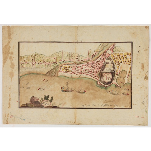
Piano di Nizza.
Rare 1797 manuscript map of Nice, with the French navy attacking from the sea. Unknown author, Italian, but map attributed to an original, probably broadsheet map by Mollieras (?). Good plan of the layout of Nice and the port and coast as was in 1797. Ships are perhaps a trifle naive. This attack is not covered by any other antique maps or prints.The sheet is watermarked with the initials JH & Z, for Jan Honig and Zoonen, a firm of papermakers operating in Zaandijk, north of Amsterdam operating ...
€900
Maker : ANONYMOUS
Place : Italy
Date : after 1797
![[John Smith caught by the French.]](/uploads/cache/40473-500x500.jpg)
[John Smith caught by the French.]
In 1615, during one of John Smith’s voyages across the Atlantic, he was caught by some French pirates. While at sea in captivity he was forced to suffer great hardships but, one night during a storm in the Bay of Biscay when the crew were forced below deck, he managed to escape in a rowing boat. All night he was tossed about by the waves with only a pike to help him steer. The small boat was eventually driven ashore on the island of Charante where some bird-catchers found him almost dead from ...
€75
Maker : GOTTFRIED, J.L. / DE BRY.
Place : Frankfurt, M.Merian
Date : 1633
![Parisius & Maguncia. [Paris & Munich] Folio XXXIX](/uploads/cache/29718-500x500.jpg)
Parisius & Maguncia. [Paris & Munich] Folio XXXIX
Imaginary view of Paris and on verso Munich : however the earliest obtainable views of this period.In the forground a large vessel, who was the symbol of the powerful corporate body of the Marchands de l'eau, and is dating back to the Middle Ages. The city motto, "Fluctuat nec mergitur" ("It is beaten by the waves without being submerged") is equally a reference to this vessel. The first mention of coat of arms of Paris with the vessel appears as early as 1190 when Philippe Augustus gave the des...
€900
Maker : SCHEDEL, H.
Place : Nuremberg
Date : 12 July 1493
Postage & Shipping
-
Item Location
Terms and conditions - Item Location
- 75013, Ile-de-France, France
- Ships To
- United States, United Kingdom, Albania, Argentina, Armenia, Australia, Austria, Bahamas, Belgium, Bermuda, Bosnia and Herzegowina, Brazil, Bulgaria, Canada, Chile, China, Costa Rica, Denmark, Dominica, Egypt, El Salvador, Finland, France, Germany, Greece, Guatemala, Hong Kong, Hungary, Iceland, India, Italy, Japan, Korea (South), Kuwait, Liechtenstein, Lithuania, Luxembourg, Madagascar, Mexico, Monaco, Morocco, Netherlands, Netherlands Antilles, New Zealand, Norway, Paraguay, Peru, Philippines, Poland, Portugal, Qatar, Reunion, Romania, San Marino, Saudi Arabia, Seychelles, Singapore, Slovenia, South Africa, Spain, Sri Lanka, Suriname, Sweden, Switzerland, Taiwan, Thailand, Tunisia, Turkey, United Arab Emirates, Uruguay, Vietnam
- Pick-ups
- Buyer can pick-up
This item is owned and offered by the seller Librairie_Loeb-Larocque - All items are available for immediate sale, offered subject to prior sale.
Invoices are created by the seller by using our shopping cart or be prepared by the seller the day following the order and are emailed to you.
Items offeres by different sellers are invoiced separately.
Shipping fees are extra. The buyer is responsible for all applicable taxes, including any VAT, customs clearance, import duties, or equivalent costs arriving at the customer's home border. Payment is due on receipt of the invoice. The item(s) are shipped as soon as possible after receipt of your payment.
Before buying please read the complete Terms Conditions of Sale.
- Payment Methods
- Visa, Mastercard, Bank Transfer, American Express, iDEAL, PayPal, Google Pay
- Returns Accepted
- No
Post Message
Feel free to ask the seller a question. Please note that the seller could be located in an area with a different time zone. Our seller will do their best to respond within 24 hours.Post your message below.
Sign in to ask the seller a question.
![A Map of the United States and Canada, New-Scotland, New-Brunswick and New-Foundland ... [together with] A Map of the West-Indies and of the Mexican-Gulph...](/uploads/cache/39235-500x500.jpg)