ID: 398
Open
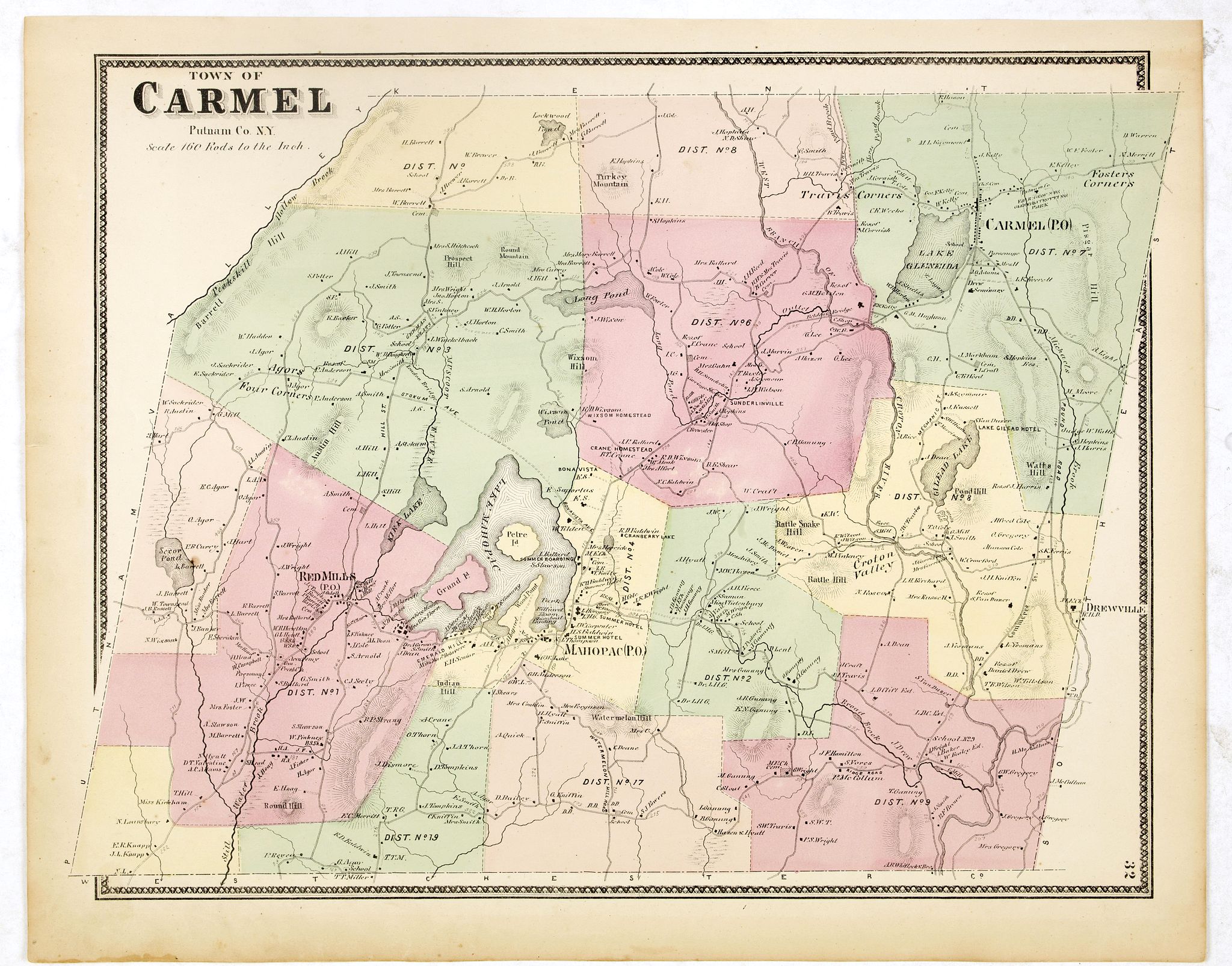
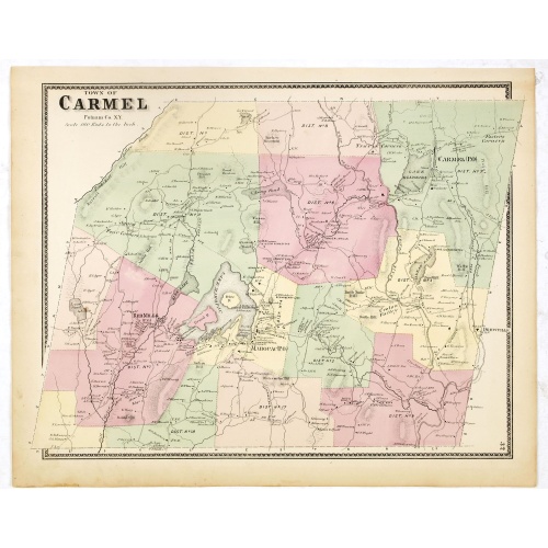
Town of Carmel.
BuyNow for €80
- Maker :
- DE BEERS, F.W.
- Place :
- New York
- Date :
- 1867
- Color :
- In original color
- Height mm.:
- 405
- Width mm.:
- 320
- Condition :
- Some very light age-toning but generally in very fine to mint condition.
- Bibliography :
- Barbara B. McCorkle 'The Strange Case of F.W. Beers and The Atlas of New York and Vicinity' in Meridian 5, pp.39-43. cf. Phillips 2290; cf. Rumsey 4631. Ristow, American Maps and Mapmakers, chapter 25.
- Seller's ref. :
- 37662
This item is offered by Librairie_Loeb-Larocque
See other Items from this seller- Postage
-
France
€15 to France
- Select Country
- Zip/Post Code
- Quantity
€80
Description
Fine lithographed map of the town of Carmel. From : "Atlas of New York and vicinity" published by Beers, Ellis & Soule, 95 Maiden Lane, New York. The map provides the names of specific homeowners, as well as information about the occupations and physical locations of the various tradesmen in each village from Beer's famous county atlas "Atlas of New York and vicinity," "a documentary record of nineteenth-century life and delightful specimens of American folk art."F. W. Beers, along with other members of his family, were among the leading county atlas publishers in the period immediately following the Civil War. Their atlases provide "a detailed cartographical, biographical, and pictorial record of a large segment of rural America in the Victorian age" (Ristow).
Beers first published his Atlas of New York & Vicinity in 1867. McCorkle and others have observed that various issues of the atlas were published in that year and the following with significant differences in the number and selection of maps included by the publisher. This was the result of clever marketing by Beers, intending to sell the atlases to customers in specific regions.
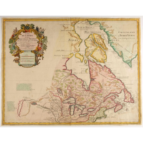
Carte du Canada ou de la Nouvelle France.
Fourth state of the map of Canada published by Delisle with the imprint "sur le Quai de l’Horloge a l’Aigle d’Or avec Privilege pour 20 ans, 1703". Beneath the title, Renard’s imprint is erased.Including the fictitious discoveries of Baron de Lahoutan: the legendary River Longue etc. The north west corner of Hudson Bay is left open, leaving the possibility of a north west passage open. De l'Isle's map was the first to show Detroit (founded by Cadillac) and the first to mention a settleme...
€500
Maker : DE L'ISLE, G.
Place : Paris
Date : 1703
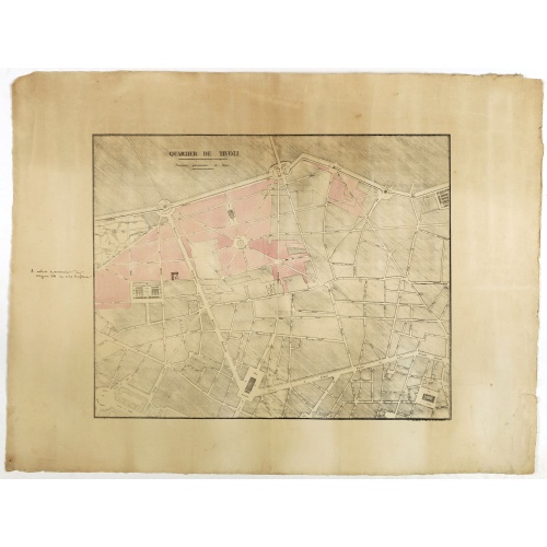
Quartier de Tivoli Nouveaux pereements de Rues.
Plan of the center of Paris showing Tivoli district with Madalene and Clichy. Lithography and pen and ink. Drawn in are the planned workshop of Serrurerie Théophile Mignon, 30 rue de la Bienfaisance.
€75
Maker : ANNONYMOUS
Place : Paris
Date : ca.1835
![[John Smith caught by the French.]](/uploads/cache/40473-500x500.jpg)
[John Smith caught by the French.]
In 1615, during one of John Smith’s voyages across the Atlantic, he was caught by some French pirates. While at sea in captivity he was forced to suffer great hardships but, one night during a storm in the Bay of Biscay when the crew were forced below deck, he managed to escape in a rowing boat. All night he was tossed about by the waves with only a pike to help him steer. The small boat was eventually driven ashore on the island of Charante where some bird-catchers found him almost dead from ...
€75
Maker : GOTTFRIED, J.L. / DE BRY.
Place : Frankfurt, M.Merian
Date : 1633
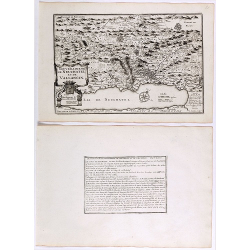
Souveraineté de Neuchatel et de Vallangin.
Map of the Neuchatel region, from Nicolas de Fer's "L'Atlas curieux ou le Monde réprésente dans des cartes. "The "Atlas Curieux" is a geographic encyclopedia of images and a celebration of the French Empire under the Sun King, with maps of French possessions in the western hemisphere, maps of France, with detailed views of the grand waterworks at Marly, views of the great palaces and chateaux, views and plans of the Paris Observatory, and samples of military architecture. Issued in six annual ...
€60
Maker : DE FER, N.
Place : Paris
Date : 1705
Postage & Shipping
-
Item Location
Terms and conditions - Item Location
- 75013, Ile-de-France, France
- Ships To
- United States, United Kingdom, Albania, Argentina, Armenia, Australia, Austria, Bahamas, Belgium, Bermuda, Bosnia and Herzegowina, Brazil, Bulgaria, Canada, Chile, China, Costa Rica, Denmark, Dominica, Egypt, El Salvador, Finland, France, Germany, Greece, Guatemala, Hong Kong, Hungary, Iceland, India, Italy, Japan, Korea (South), Kuwait, Liechtenstein, Lithuania, Luxembourg, Madagascar, Mexico, Monaco, Morocco, Netherlands, Netherlands Antilles, New Zealand, Norway, Paraguay, Peru, Philippines, Poland, Portugal, Qatar, Reunion, Romania, San Marino, Saudi Arabia, Seychelles, Singapore, Slovenia, South Africa, Spain, Sri Lanka, Suriname, Sweden, Switzerland, Taiwan, Thailand, Tunisia, Turkey, United Arab Emirates, Uruguay, Vietnam
- Pick-ups
- Buyer can pick-up
This item is owned and offered by the seller Librairie_Loeb-Larocque - All items are available for immediate sale, offered subject to prior sale.
Invoices are created by the seller by using our shopping cart or be prepared by the seller the day following the order and are emailed to you.
Items offeres by different sellers are invoiced separately.
Shipping fees are extra. The buyer is responsible for all applicable taxes, including any VAT, customs clearance, import duties, or equivalent costs arriving at the customer's home border. Payment is due on receipt of the invoice. The item(s) are shipped as soon as possible after receipt of your payment.
Before buying please read the complete Terms Conditions of Sale.
- Payment Methods
- Visa, Mastercard, Bank Transfer, American Express, iDEAL, PayPal, Google Pay
- Returns Accepted
- No
Post Message
Feel free to ask the seller a question. Please note that the seller could be located in an area with a different time zone. Our seller will do their best to respond within 24 hours.Post your message below.
Sign in to ask the seller a question.