ID: 339
Open
Listing ID: #339 has been added to your wishlist.
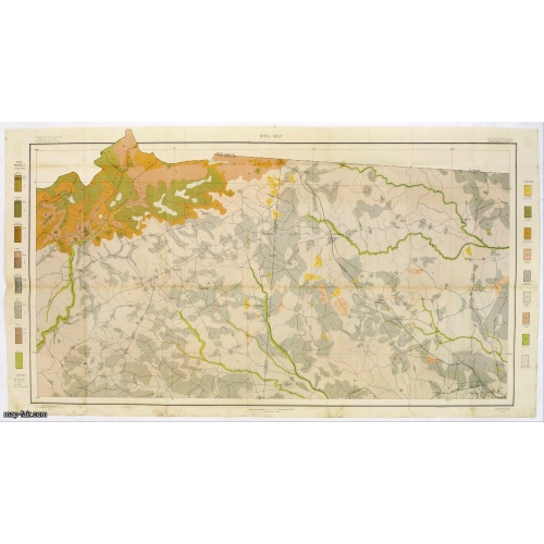
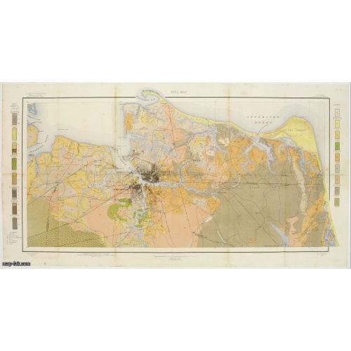
Soil map - South Carolina Campobello Sheet.
BuyNow for $50
- Maker :
- U.S. DEPT. OF ARGICULTURE
- Place :
- New York, 1903
- Date :
- 1903
- Color :
- Color printed
- Height mm.:
- 475
- Width mm.:
- 910
- Condition :
- Lithography in 6 colors. Folded as issued. Some minor spotting, hardly noticeable. Generally very good.
- Bibliography :
- -
- Seller's ref. :
- 08268
This item is offered by Paulus_Swaen_Old_Maps
See other Items from this seller- Postage
-
Europe
$34 to France
- Select Country
- Zip/Post Code
- Quantity
$50
Description
Early color lithographed soil map by Julius Bien & Co. in New York for the Department of Agriculture.Legends at the side provide detail on soil type, etc. They also include interesting details of the cities, roads, railroads, rivers, and canals. A scale of 1" = 1 mile.
The map gives great detail of the northern part of South Carolina, including Spatanburg and the area northwest of it, with Tiger River, South Pacolet River, and North Saluda River in the lower right-hand corner, in 1903. A.G. Mangum and Aldert S. Root surveyed the soil in the same year. To the left and right, color keys indicate the different types of soil.
Upper left: U.S.Department of Agriculture, Bureau of soils, Milton Whitney, Chief.
Julies Bien (later Bien & Co) was born and educated in Germany and moved to America in 1849. He started his business as an engraver and lithographer, later trading as a publisher. He built up a leading map making establishment employing more than two hundred people and several lithographic and copperplate presses. Worked extensively for US Government.
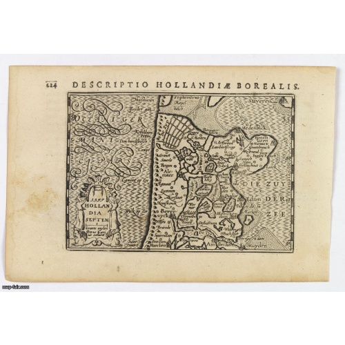
Hollandia Septentrionalis.
An attractive miniature map of the north Holland, northwards from Amsterdam to the Zijpe polder, published by Petrus Bertius, in Amsterdam at the beginning of the seventeenth century. It features a decorative title, sea hatching, elaborate cursive script, dykes and polders, some towns etc.This example is from the Tabularum Geographicarum Contractarum. Bertius (1565-1629) was a Flemish cartographer, theologian, historian and geographer. Although he published much in the fields of history, theolog...
$150
Maker : LANGENES, B. / BERTIUS, P.
Place : Amsterdam
Date : 1606
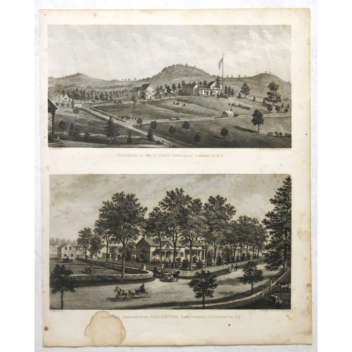
Résidence of WM H.Drew Southeast Putnam Co.N.Y / Lake Farm Résidence of John V.Storm East Fiskill Dutches Co.N.Y.
Two heliographic prints on one sheet : " Résidence of WM H.Drew Southeast Putnam Co.N.Y / Lake Farm Résidence of John V.Storm East Fiskill Dutches Co.N.Y." after design by R.K.Sneden.From Beer's famous county atlas "Atlas of New York and vicinity", "a documentary record of nineteenth century life and delightful specimens of American folk art". F. W. Beers, along with other members of his family, were among the leading county atlas publishers in period immediately following the Civil War. Their...
$90
Maker : DE BEERS, F.W.
Place : New York,1867
Date : 1867

A new mape of Ye XVII Provinces of Low Germanie.
Showing all 17 Provinces of the Netherlands before the split between Spain and the Protestant Provinces under the House of Orange.The map was first published. At the same time, the war of independence was still being fought against Philip II. With columns of figures on either side and surmounted by eight city prospects. A famous and most decorative item.A fourth state published by Thomas Basset and Richard Chiswell. The date has been removed and Speed's name has been added to the title cartouche...
$2.300
Maker : SPEED, J.
Place : London, 1676
Date : 1626
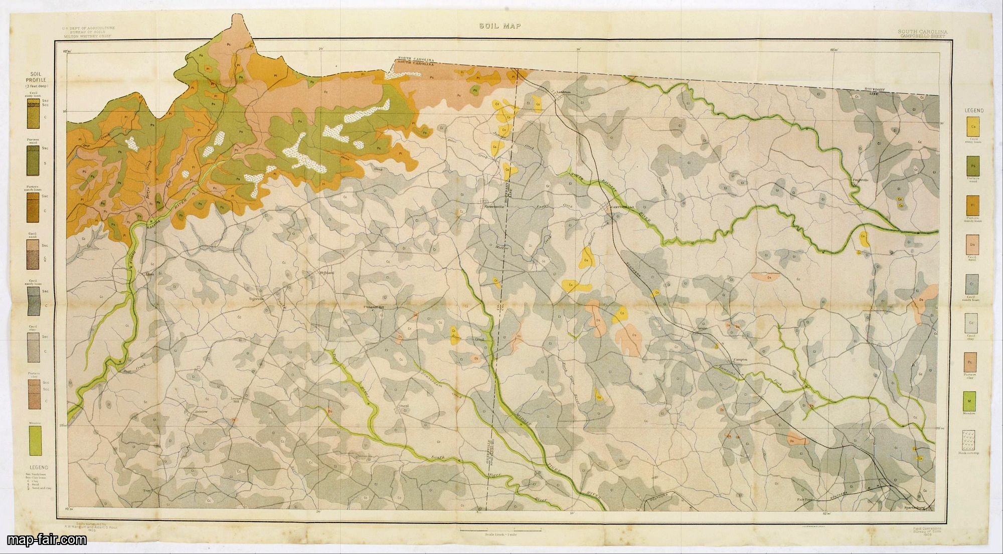
Soil map - Virginia Norfolk Sheet.
Soil map printed by Julius Bien & Co. in New York for the Department of Agriculture. The map gives great detail of the area centered on Norfolk, Potsmouth, Chesapeake, Virginia Beach in the year 1903. Soils are surveyed by J.E.Lapham in the same year. To the left and right, color keys to the different soil types.Upper left: U.S.Department of Agriculture, Bureau of soils, Milton Whitney, Chief.Julies Bien (later Bien & Co) was born and educated in Germany, and moved to America in 1849. He started...
$50
Maker : U.S. DEPT. OF ARGICULTURE
Place : New York 1903
Date : 1903
Postage & Shipping
-
Item Location
Terms and conditions - Item Location
- 75013, Alsace, France
- Ships To
- United States, United Kingdom, Albania, Argentina, Armenia, Australia, Azerbaijan, Bahamas, Belgium, Bermuda, Cambodia, Canada, Chile, China, Croatia, Cyprus, Czech Republic, Denmark, Estonia, Finland, France, Germany, Gibraltar, Greece, Greenland, Guatemala, Hong Kong, Iceland, India, Indonesia, Israel, Italy, Japan, Latvia, Lithuania, Luxembourg, Malta, Mexico, Monaco, Netherlands, Norway, Singapore, Spain, Sweden, Switzerland, Turkey
- Pick-ups
- No pick-ups
This item is owned and offered by the seller Paulus_Swaen_Old_Maps - All items are available for immediate sale, offered subject to prior sale.
Invoices are created by the seller by using our shopping cart or be prepared by the seller the day following the order and are emailed to you.
Items offeres by different sellers are invoiced separately.
Shipping fees are extra. The buyer is responsible for all applicable taxes, including any VAT, customs clearance, import duties, or equivalent costs arriving at the customer's home border. Payment is due on receipt of the invoice. The item(s) are shipped as soon as possible after receipt of your payment.
Before buying please read the complete Terms Conditions of Sale.
- Payment Methods
- Visa, Mastercard, Bank Transfer, iDEAL, PayPal
- Returns Accepted
- No
Post Message
Feel free to ask the seller a question. Please note that the seller could be located in an area with a different time zone. Our seller will do their best to respond within 24 hours.Post your message below.
Sign in to ask the seller a question.