
ID: 361
Open
![A Map of the United States and Canada, New-Scotland, New-Brunswick and New-Foundland ... [together with] A Map of the West-Indies and of the Mexican-Gulph...](/uploads/39235.jpg)
![A Map of the United States and Canada, New-Scotland, New-Brunswick and New-Foundland ... [together with] A Map of the West-Indies and of the Mexican-Gulph...](/uploads/39235C.jpg)
A Map of the United States and Canada, New-Scotland, New-Brunswick and New-Foundland ... [together with] A Map of the West-Indies and of the Mexican-Gulph...
BuyNow for €5.000
- Maker :
- P.A.F. TARDIEU
- Place :
- Paris
- Date :
- 1806
- Color :
- In original outline colors
- Height mm.:
- 880
- Width mm.:
- 758
- Condition :
- Two maps, each map segmented and laid on cartographic linen, as issued. (530 x 800mm.). Together forming a wall map of 880 x 758mm. Each map dissected in 18 parts and with the engraved label of Ch.Picquet on the verso with title in lead pencil. Both maps
- Bibliography :
- -
- Seller's ref. :
- 39235
This item is offered by Librairie_Loeb-Larocque
See other Items from this seller- Postage
-
Standard Shipping
€0 to France
- Select Country
- Zip/Post Code
- Quantity
€5.000
Description
A Map of the United States and Canada, New-Scotland, New-Brunswick and New-Foundland / Carte des Etats Unis, avec Le Canada, la Nouvelle Ecosse, le Nouveau Brunswick & Terre-Neuve. Dressée par LAPIE, Capitaine-Ingénieur-Géographe. Publiée par P.A.F.TARDIEU, Graveur, Editeur propriétaire a Paris. Déposée à la Bibliothèque Imperiale, le 10 Juin 1806.[together with]
A Map of the West-Indies and of the Mexican-Gulph / Carte des Indes Occidentales et du Golfe du Mexique. Dressée par LAPIE, Capitaine-Ingénieur-Géographe. Publiée par P.A.F.TARDIEU, Graveur, Editeur propriétaire a Paris. Déposée à la Bibliothèque Imperiale, le 5 Septembere 1806.
[together with]
Its original case, made from boards covered with marbled paper and label.
Two maps, each map segmented and laid on cartographic linen, as issued. (530 x 800mm.) dissected in 18 parts and with the engraved label of Ch. Picquet on the verso with title in lead pencil. Both maps have signs of water staining. Together with contemp. marbled case with label “INDIES / OCCIDENT”, case is used.The norther part published in June (first state of 2, later state dates September) the lower part dated September.
This beautiful and rare set of two maps drawn by Pierre Lapie, a Colonel in the Imperial Corps of Engineers, issued by J.A. Dezauche in 1806 is largely based on the work of Aaron Arrowsmith, who first published his monumental map of North America in 1796, the current map shows the United States at a time of great transition, just after the acquisition of the Louisiana Territory, but before the extent of the western discoveries of Lewis and Clark during their exploring expedition of 1804, 1805, 1806, and those of Zebulon Pike of 1806 and 1807 is known.
Mississippi and Georgia Territories are shown, and are still inhabited by the Creek and Chactaw Indians. New Mexico is clearly shown as the property of French. The map extends to the northern coastline of South America, and includes detailed mapping of the West Indies and the Caribbean.
Remarkably fine engraving, as is characteristic of Tardieu's maps. The map was apparently issued both as a separate map of just the United States and also in a pairing with a map of the Caribbean and Central America, bringing the size to 35 x 30 inches.
This extremely rare large-scale map of the Gulf of Mexico shows the European possessions through a color-coded key adjacent to the title cartouche. The regions and islands controlled by the French, Spanish, British, Danish, Dutch, and Swedish are shown, along with the area belonging to the United States. The map was issued shortly after the Louisiana Purchase (1803), the creation of Mississippi Territory (1804) and the creation of Michigan Territory (1805) and is among the earliest printed maps to illustrate these features.
Florida is divided into East and West, and extends to the Mississippi River. There is great topographical detail throughout, and rivers and place names fill the map.
East Florida
A detail from the 1806 map of the West Indies showing the Spanish territory of Floride Oriental, or East Florida. This map shows coastal features, major lakes and rivers, and settlements. Various place names reflect French, English, and Spanish variations, such as Cayo de Huesos for Key West, Baie Chatham for Ponce de Leon Bay, and Lac du St. Esprit or Lac de Mayaco for Lake Okeechobee.
Place Names: 1800-1819, Floride Oriental, East Florida, S. Marc d'Apalache, St. Marks, Baie du St. Esprit, Tampa Bay, I. Sanybel, Sanibel Island, Baie Chatham, Cayo de Huesos, Key West, Cap Canavaral, Cape Canaveral, St. Augustine, Saint Augustine, R. S. Jean, St. Johns River, I. Amelia, Lac du St. Esprit, Lac du Mayaco, Lake Okeechobee.
West Florida
This map shows coastal features, major lakes and rivers, and settlements of West Florida. Various place names reflect French, English, and Spanish variations, such as Baie St. Joseph for St. Joseph Bay.
Place Names: 1800-1819, Floride Occidentale, West Florida, Pensacola, Campbell Town, Baie de St. Joseph, St. Joseph Bay, C. St. Blaise, Cape San Blas, Appalachicola R., Apalachicola River
![[Spanish take over Cusco] / [Atahualpa is garrotted].](/uploads/cache/41092-500x500.jpg)
[Spanish take over Cusco] / [Atahualpa is garrotted].
Two engravings. [486] After Atahualpa was killed, Pizarro set out with his troops to find the city of Cuzco, which he had heard was rich in gold. The journey from Cajamarca to Cuzco by road was nearly a thousand miles and took three months. Although there was considerable resistance to the Spanish during this long march, the final descent into the great city, in November 1533, was in fact, not as portrayed but a relatively peaceful affair. [485] While Atahualpa was still held captive rumors spre...
€80
Maker : GOTTFRIED, J.L. / DE BRY.
Place : Frankfurt, M.Merian
Date : 1633
![[Spilbergen's fleet visits the island of Santa Maria] / [The Dutch visit Isla Mocha].](/uploads/cache/41090-500x500.jpg)
[Spilbergen's fleet visits the island of Santa Maria] / [The Dutch visit Isla Mocha].
Two engravings. [514] On 29th May, 1615, Spilbergen’s fleet anchored further north, off an island called Santa María that was separated by a narrow stretch of water (A), from Punta Lavapié on the mainland. Four of the ships (I) anchored in the bay, while the fifth (H) anchored closer. The Dutch went ashore in small boats (F), where they saw Spanish soldiers on horseback (B), so they arranged themselves for battle (C). There were several confrontations (E), during which many Dutchmen died but...
€80
Maker : GOTTFRIED, J.L. / DE BRY.
Place : Frankfurt, M.Merian
Date : 1633
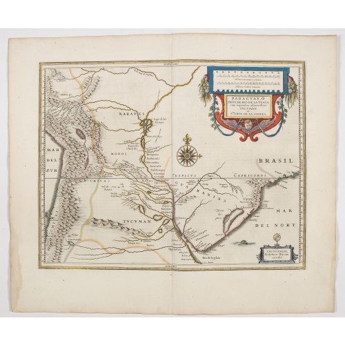
Paraguayo prov. de Rio de La Plata cum regionibus..
A beautiful map of Paraguay, and parts of Peru, Chile, Argentina, Brazil and Bolivia. Much of the area was still "Terra Incognita" so there are few towns and cities shown. The Andes are clearly shown to the west as well as the river systems.The Renaissance cartouche adds a special decorative accent to the map. The small cartouche in the lower right gives the name of the publisher. From early on Willem Jansz. Blaeu aimed of publishing an atlas to compete with the Hondius-Jansson Atlas. By 1630, ...
€600
Maker : BLAEU, W.
Place : Amsterdam
Date : 1644
![Boertige reis door Europa. . . [with] Europa volgens de nieuwste verdeeling. . .](/uploads/cache/32642-500x500.jpg)
Boertige reis door Europa. . . [with] Europa volgens de nieuwste verdeeling. . .
Rare illustrated publication including a rare map of Europe as a regal queen with the title "Geheimzinnige toebereidselen tot eene boertige reis door Europa. [...] voorgeleezen in [...] de maatschappij der verdiensten, onder de spreuk: Felix Meritis. / By A. Fokke Simonsz".The book contains a map of Europe (168x2369mm.) engraved by H.Klockhoff and a cartographical curiosity, "Europa volgens de nieuwste verdeeling...", Europe as a regal queen but with an interesting twist and political commentary...
€1.900
Maker : BOHN, F.
Place : Haarlem
Date : 1794
Postage & Shipping
-
Item Location
Terms and conditions - Item Location
- Amsterdam, , Netherlands
- Ships To
- United States, United Kingdom, Albania, Argentina, Armenia, Australia, Austria, Bahamas, Belgium, Bermuda, Bosnia and Herzegowina, Brazil, Bulgaria, Canada, Chile, China, Costa Rica, Denmark, Dominica, Egypt, El Salvador, Finland, France, Germany, Greece, Guatemala, Hong Kong, Hungary, Iceland, India, Italy, Japan, Korea (South), Kuwait, Liechtenstein, Lithuania, Luxembourg, Madagascar, Mexico, Monaco, Morocco, Netherlands, Netherlands Antilles, New Zealand, Norway, Paraguay, Peru, Philippines, Poland, Portugal, Qatar, Reunion, Romania, San Marino, Saudi Arabia, Seychelles, Singapore, Slovenia, South Africa, Spain, Sri Lanka, Suriname, Sweden, Switzerland, Taiwan, Thailand, Tunisia, Turkey, United Arab Emirates, Uruguay, Vietnam
- Pick-ups
- Buyer can pick-up
This item is owned and offered by the seller Librairie_Loeb-Larocque - All items are available for immediate sale, offered subject to prior sale.
Invoices are created by the seller by using our shopping cart or be prepared by the seller the day following the order and are emailed to you.
Items offeres by different sellers are invoiced separately.
Shipping fees are extra. The buyer is responsible for all applicable taxes, including any VAT, customs clearance, import duties, or equivalent costs arriving at the customer's home border. Payment is due on receipt of the invoice. The item(s) are shipped as soon as possible after receipt of your payment.
Before buying please read the complete Terms Conditions of Sale.
- Payment Methods
- Visa, Mastercard, Bank Transfer, American Express, iDEAL, PayPal, Google Pay
- Returns Accepted
- No
Post Message
Feel free to ask the seller a question. Please note that the seller could be located in an area with a different time zone. Our seller will do their best to respond within 24 hours.Post your message below.
Sign in to ask the seller a question.
![A Map of the United States and Canada, New-Scotland, New-Brunswick and New-Foundland ... [together with] A Map of the West-Indies and of the Mexican-Gulph...](/uploads/cache/39235-500x500.jpg)