ID: 352
Open
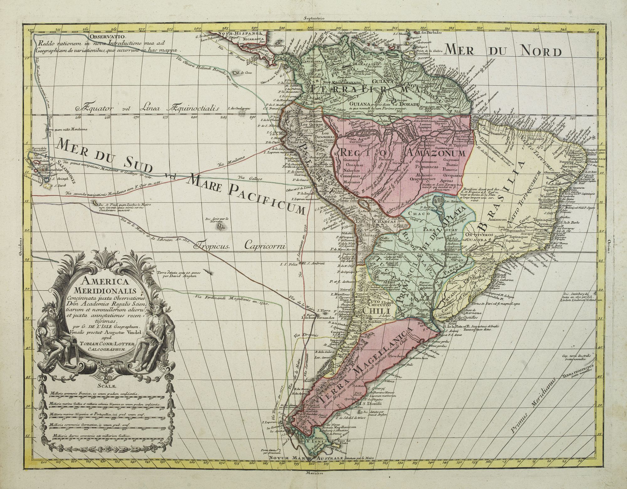
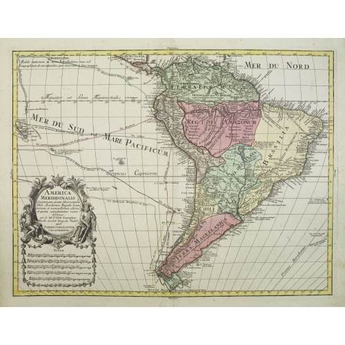
America Meridionalis.
BuyNow for €550
- Maker :
- LOTTER, T.C.
- Place :
- Augsburg
- Date :
- c. 1760
- Color :
- In original color
- Height mm.:
- 452
- Width mm.:
- 588
- Condition :
- With an uncolored title cartouche.
- Bibliography :
- -
- Seller's ref. :
- 27017
This item is offered by Librairie_Loeb-Larocque
See other Items from this seller- Postage
-
France
€15 to France
- Select Country
- Zip/Post Code
- Quantity
€550
Description
This is the more scarce edition with the title cartouche lower left surrounded by Neptune and a native Indian.A rather accurate depiction and descriptions of South America. Brazil is slightly enlarged and bears mainly names of the costal zone. The inland was rather unknown at the time and regarded as both pagan and dangerous area like the Amazon.
Argentina with Cape Horn and the Falkland Islands are merely deformed. The map was published by Matthäus Seutter's son in law Tobias Conrad Lotter, who continued the work and renamed many of Seutter's map with his own.
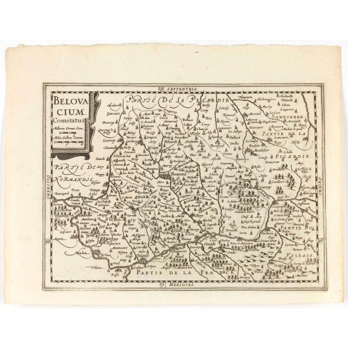
Belovacium comitatus.
Early map centered north of Paris. With Latin text on verso. Engraved by Petrus Kaerius. Shortly after the publication of big folio-atlases the need was apparently felt for a smaller sized atlas, one that would be handier and, above all, cheaper. Joh. Cloppenburgh published in 1630 a atlas based on Mercator's pocket map, but in a slightly larger size. He published a Latin text edition in 1632.
€75
Maker : CLOPPENBURGH, J.E.
Place : Amsterdam
Date : 1632
-500x500.jpg)
Dépt. De La Haute Loire. N°42.
Map of the Upper Loire region in France.Lovely map from one of the last decorative atlases of the nineteenth century.The rather simple map is framed by medallion portraits and coats of arms, and is set against a background of scenes of the countryside, products and activities indigenous to the region filling the foreground.Victor Levasseur's "Atlas National Illustre" and "Atlas Universel Illustre" are among the last great decorative atlases published. This map comes from the Atlas National Illus...
€50
Maker : LEVASSEUR, V.
Place : Paris
Date : A. Combette, 1852
![Ancienne Gavle. [de l'Europe]](/uploads/cache/38440-500x500.jpg)
Ancienne Gavle. [de l'Europe]
A fine and uncommon early 17th century map of France.From the French text edition of "Description d'Univers", 1683. by Allain Manneson Mallet (1630-1706), a well travelled military engineer and geographer who worked in 17th century France under King Louis XIV.
€50
Maker : MALLET, A.M.
Place : Paris
Date : 1683
Postage & Shipping
-
Item Location
Terms and conditions - Item Location
- 75013, Ile-de-France, France
- Ships To
- United States, United Kingdom, Albania, Argentina, Armenia, Australia, Austria, Bahamas, Belgium, Bermuda, Bosnia and Herzegowina, Brazil, Bulgaria, Canada, Chile, China, Costa Rica, Denmark, Dominica, Egypt, El Salvador, Finland, France, Germany, Greece, Guatemala, Hong Kong, Hungary, Iceland, India, Italy, Japan, Korea (South), Kuwait, Liechtenstein, Lithuania, Luxembourg, Madagascar, Mexico, Monaco, Morocco, Netherlands, Netherlands Antilles, New Zealand, Norway, Paraguay, Peru, Philippines, Poland, Portugal, Qatar, Reunion, Romania, San Marino, Saudi Arabia, Seychelles, Singapore, Slovenia, South Africa, Spain, Sri Lanka, Suriname, Sweden, Switzerland, Taiwan, Thailand, Tunisia, Turkey, United Arab Emirates, Uruguay, Vietnam
- Pick-ups
- No pick-ups
This item is owned and offered by the seller Librairie_Loeb-Larocque - All items are available for immediate sale, offered subject to prior sale.
Invoices are created by the seller by using our shopping cart or be prepared by the seller the day following the order and are emailed to you.
Items offeres by different sellers are invoiced separately.
Shipping fees are extra. The buyer is responsible for all applicable taxes, including any VAT, customs clearance, import duties, or equivalent costs arriving at the customer's home border. Payment is due on receipt of the invoice. The item(s) are shipped as soon as possible after receipt of your payment.
Before buying please read the complete Terms Conditions of Sale.
- Payment Methods
- Visa, Mastercard, Bank Transfer, American Express, iDEAL, PayPal, Google Pay
- Returns Accepted
- No
Post Message
Feel free to ask the seller a question. Please note that the seller could be located in an area with a different time zone. Our seller will do their best to respond within 24 hours.Post your message below.
Sign in to ask the seller a question.