ID: 419
Open
Listing ID: #419 has been added to your wishlist.
Dépt. De La Haute Loire. N°42.
BuyNow for €50
- Maker :
- LEVASSEUR, V.
- Place :
- Paris
- Date :
- A. Combette, 1852
- Color :
- In original outline colors
- Height mm.:
- 290
- Width mm.:
- 420
- Condition :
- Very good condition. Steel engraved map in original out-line colors, the outer decoration is uncolored, as issued.
- Bibliography :
- -
- Seller's ref. :
- 27121
This item is offered by Librairie_Loeb-Larocque
See other Items from this seller- Postage
-
France
€15 to France
- Select Country
- Zip/Post Code
- Quantity
€50
Description
Map of the Upper Loire region in France.Lovely map from one of the last decorative atlases of the nineteenth century.
The rather simple map is framed by medallion portraits and coats of arms, and is set against a background of scenes of the countryside, products and activities indigenous to the region filling the foreground.
Victor Levasseur's "Atlas National Illustre" and "Atlas Universel Illustre" are among the last great decorative atlases published.
This map comes from the Atlas National Illustre.
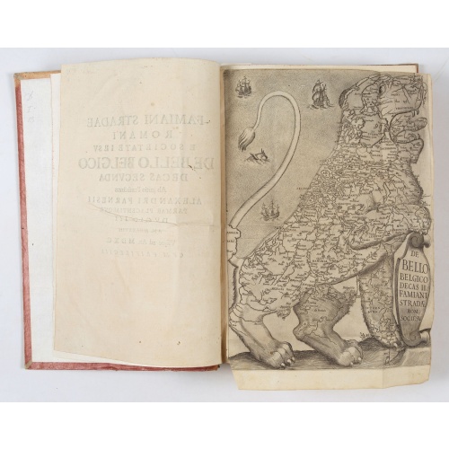
De Bello Belgico, Decas Prima / Decas Secunda.
With 2 engraved titles of the 'Leo Belgicus', with one paw resting on a shield bearing the title, large woodcut printer's device on the colophons, and 30 richly engraved views and plans of battles and sieges, 28 double-page and 2 full-page, by Johanness W.Bauer, J.Miele, Jacomo Cortese, a.o. Two examples of the famous Leo Belgicus map are included. Among the greatest decorative works of early cartography is a series of arresting maps showing The Netherlands and Belgium in the shape of a lion.Thi...
€6.900
Maker : STRADA, Famiano.
Place : Rome, Franciscus Corbelletus
Date : 1632-1647
[Spanish take over Cusco] / [Atahualpa is garrotted].
Two engravings. [486] After Atahualpa was killed, Pizarro set out with his troops to find the city of Cuzco, which he had heard was rich in gold. The journey from Cajamarca to Cuzco by road was nearly a thousand miles and took three months. Although there was considerable resistance to the Spanish during this long march, the final descent into the great city, in November 1533, was in fact, not as portrayed but a relatively peaceful affair. [485] While Atahualpa was still held captive rumors spre...
€80
Maker : GOTTFRIED, J.L. / DE BRY.
Place : Frankfurt, M.Merian
Date : 1633
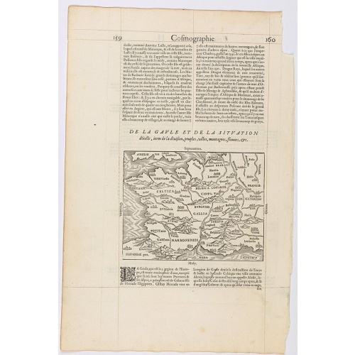
Page from La Cosmographie Universelle with map of France. (Page 160)
Text page with woodblock map of ancient France (122 x 163 mm.) In 1575 Sebastian Münster's Cosmographia was translated into French and published in Paris by François de Belle-Forest.
€75
Maker : DE BELLE-FOREST, F.
Place : Paris
Date : 1575
Carte du siège présidial Dax et seneschaucee des Lannes et des sieges de Bayonne sainct sever et Tartas qui en dependent Nouvellement dessignee Par le Sr de Classun.
Very rare map including Bayonne and Dax in the south west of France. With inset plan of "Plan de la ville Dax.". Engraved by Henri le Roy. With the address "Chez F. DLa Pointe sur le quay de l'horloge".
€900
Maker : DELA POINTE, F.
Place : Paris
Date : 1638
Postage & Shipping
-
Item Location
Terms and conditions - Item Location
- 75013, Ile-de-France, France
- Ships To
- United States, United Kingdom, Albania, Argentina, Armenia, Australia, Austria, Bahamas, Belgium, Bermuda, Bosnia and Herzegowina, Brazil, Bulgaria, Canada, Chile, China, Costa Rica, Denmark, Dominica, Egypt, El Salvador, Finland, France, Germany, Greece, Guatemala, Hong Kong, Hungary, Iceland, India, Italy, Japan, Korea (South), Kuwait, Liechtenstein, Lithuania, Luxembourg, Madagascar, Mexico, Monaco, Morocco, Netherlands, Netherlands Antilles, New Zealand, Norway, Paraguay, Peru, Philippines, Poland, Portugal, Qatar, Reunion, Romania, San Marino, Saudi Arabia, Seychelles, Singapore, Slovenia, South Africa, Spain, Sri Lanka, Suriname, Sweden, Switzerland, Taiwan, Thailand, Tunisia, Turkey, United Arab Emirates, Uruguay, Vietnam
- Pick-ups
- Buyer can pick-up
This item is owned and offered by the seller Librairie_Loeb-Larocque - All items are available for immediate sale, offered subject to prior sale.
Invoices are created by the seller by using our shopping cart or be prepared by the seller the day following the order and are emailed to you.
Items offeres by different sellers are invoiced separately.
Shipping fees are extra. The buyer is responsible for all applicable taxes, including any VAT, customs clearance, import duties, or equivalent costs arriving at the customer's home border. Payment is due on receipt of the invoice. The item(s) are shipped as soon as possible after receipt of your payment.
Before buying please read the complete Terms Conditions of Sale.
- Payment Methods
- Visa, Mastercard, Bank Transfer, American Express, iDEAL, PayPal, Google Pay
- Returns Accepted
- No
Post Message
Feel free to ask the seller a question. Please note that the seller could be located in an area with a different time zone. Our seller will do their best to respond within 24 hours.Post your message below.
Sign in to ask the seller a question.


![[Spanish take over Cusco] / [Atahualpa is garrotted].](/uploads/cache/41092-500x500.jpg)

-500x500.jpg)