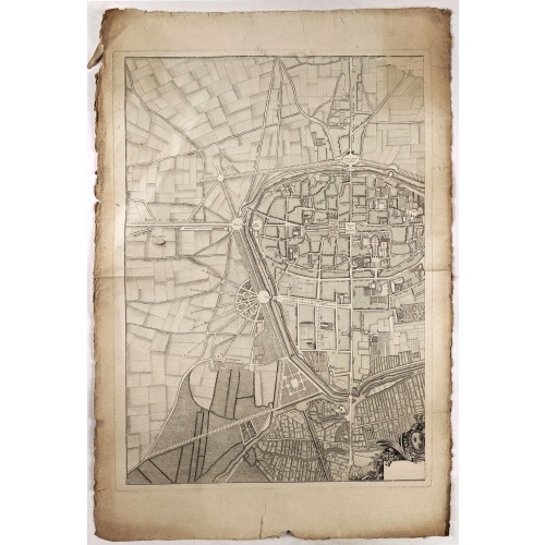
ID: 433
Open
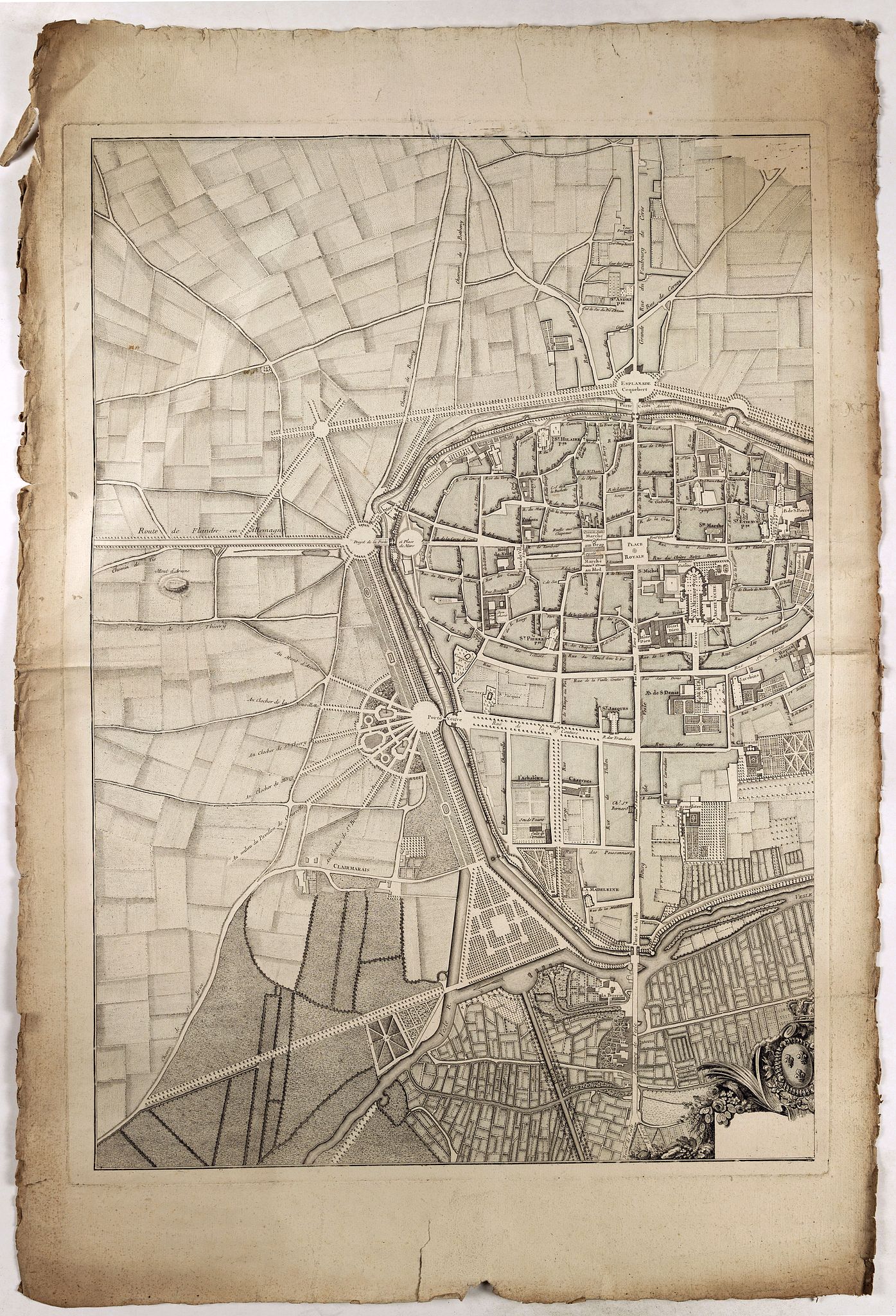
(Rheims)
BuyNow for €75
- Maker :
- ANNONYMOUS
- Place :
- France
- Date :
- 1750
- Color :
- In original color
- Height mm.:
- 800
- Width mm.:
- 560
- Condition :
- Left hand part of a 2 sheet plan of Rheims. Paper slightly age toned. Paper size : 550 x 710mm.
- Bibliography :
- -
- Seller's ref. :
- 41080
This item is offered by Librairie_Loeb-Larocque
See other Items from this seller- Postage
-
France
€15 to France
- Select Country
- Zip/Post Code
- Quantity
€75
Description
Finely engraved plan of Rheims.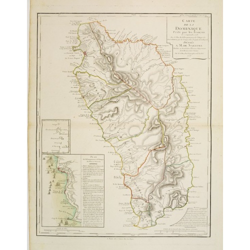
Carte de la Dominique Prise par les Francois le 7 Septembre 1778. Avec le Plan du Debarquement et de l'Attaque des Forts et Batteries par les Troupes et Les Fregates de sa Majeste
A rare map of St. Dominica, with insets of Charlotteville with its attack by the French on 7 September 1778 on the British. Also small inset map of the Caribbean islands from Antigua till Grenada. With dedication to de Sartine, a French official.
€500
Maker : BUACHE, S.
Place : Paris
Date : 1780
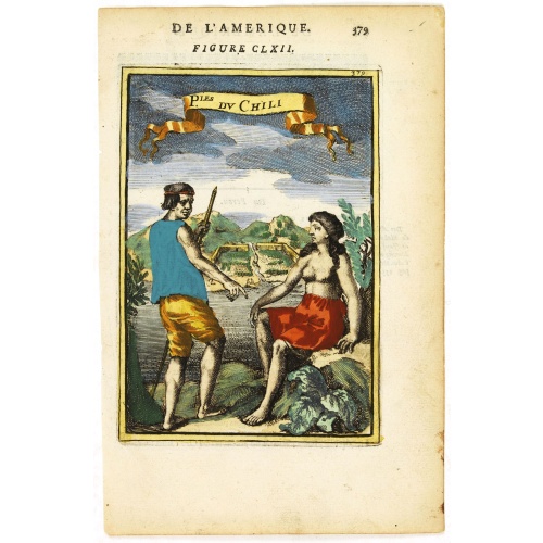
P.les du Chile.
A charming copper engraving depicting a town surrounded by a luxuriant landscape on the background and a couple of indigenous on the foreground.From the French text edition of Description d'Univers, 1683. by Allain Manneson Mallet (1630-1706), a well traveled military engineer and geographer who worked in 17th century France under King Louis XIV.
€60
Maker : MALLET, A.M.
Place : Paris
Date : 1683
![Carte generale de France. [de l'Europe]](/uploads/cache/38442-500x500.jpg)
Carte generale de France. [de l'Europe]
A fine and uncommon early 17th century map of France printed from two copper plates. Engraved by Liébaux.From the French text edition of "Description d'Univers", 1683. by Allain Manneson Mallet (1630-1706), a well travelled military engineer and geographer who worked in 17th century France under King Louis XIV.
€80
Maker : MALLET, A.M.
Place : Paris
Date : 1683
Novus de Leone Belgico eiusq topographia atq. Historica descriptione liber (…). Rerumque in Belgio maxime gestarum, inde ab anno Christi M.D.LIX. Usque ad annum M.D.LXXXVII perpetua narratione continatus.
ENLARGED EDITION, with 207 (of 208) engravings of a famous eyewitness account of the Dutch Revolt, with the famous "Leo Belgicus" map, here in its second state. One of the major sources for the history of the Low Countries during the beginning of their struggle for independence. This history of the religious wars in Belgium and Holland from 1559-87 is illustrated with Hogenberg's engravings (from his "Geschichtsblättern"), whereby the engravings for this edition were printed without the lower ...
$39.000
Maker : AITSINGER (EYZINGER), Michael von.
Place : Cologne, Gerardus Campensis for Frans Hogenberg
Date : 1588
Postage & Shipping
-
Item Location
Terms and conditions - Item Location
- Paris, Alsace, France
- Ships To
- United States, United Kingdom, Albania, Argentina, Armenia, Australia, Austria, Bahamas, Belgium, Bermuda, Bosnia and Herzegowina, Brazil, Bulgaria, Canada, Chile, China, Costa Rica, Denmark, Dominica, Egypt, El Salvador, Finland, France, Germany, Greece, Guatemala, Hong Kong, Hungary, Iceland, India, Italy, Japan, Korea (South), Kuwait, Liechtenstein, Lithuania, Luxembourg, Madagascar, Mexico, Monaco, Morocco, Netherlands, Netherlands Antilles, New Zealand, Norway, Paraguay, Peru, Philippines, Poland, Portugal, Qatar, Reunion, Romania, San Marino, Saudi Arabia, Seychelles, Singapore, Slovenia, South Africa, Spain, Sri Lanka, Suriname, Sweden, Switzerland, Taiwan, Thailand, Tunisia, Turkey, United Arab Emirates, Uruguay, Vietnam
- Pick-ups
- Buyer can pick-up
This item is owned and offered by the seller Librairie_Loeb-Larocque - All items are available for immediate sale, offered subject to prior sale.
Invoices are created by the seller by using our shopping cart or be prepared by the seller the day following the order and are emailed to you.
Items offeres by different sellers are invoiced separately.
Shipping fees are extra. The buyer is responsible for all applicable taxes, including any VAT, customs clearance, import duties, or equivalent costs arriving at the customer's home border. Payment is due on receipt of the invoice. The item(s) are shipped as soon as possible after receipt of your payment.
Before buying please read the complete Terms Conditions of Sale.
- Payment Methods
- Visa, Mastercard, Bank Transfer, American Express, PayPal, Google Pay
- Returns Accepted
- No
Post Message
Feel free to ask the seller a question. Please note that the seller could be located in an area with a different time zone. Our seller will do their best to respond within 24 hours.Post your message below.
Sign in to ask the seller a question.