ID: 378
Open
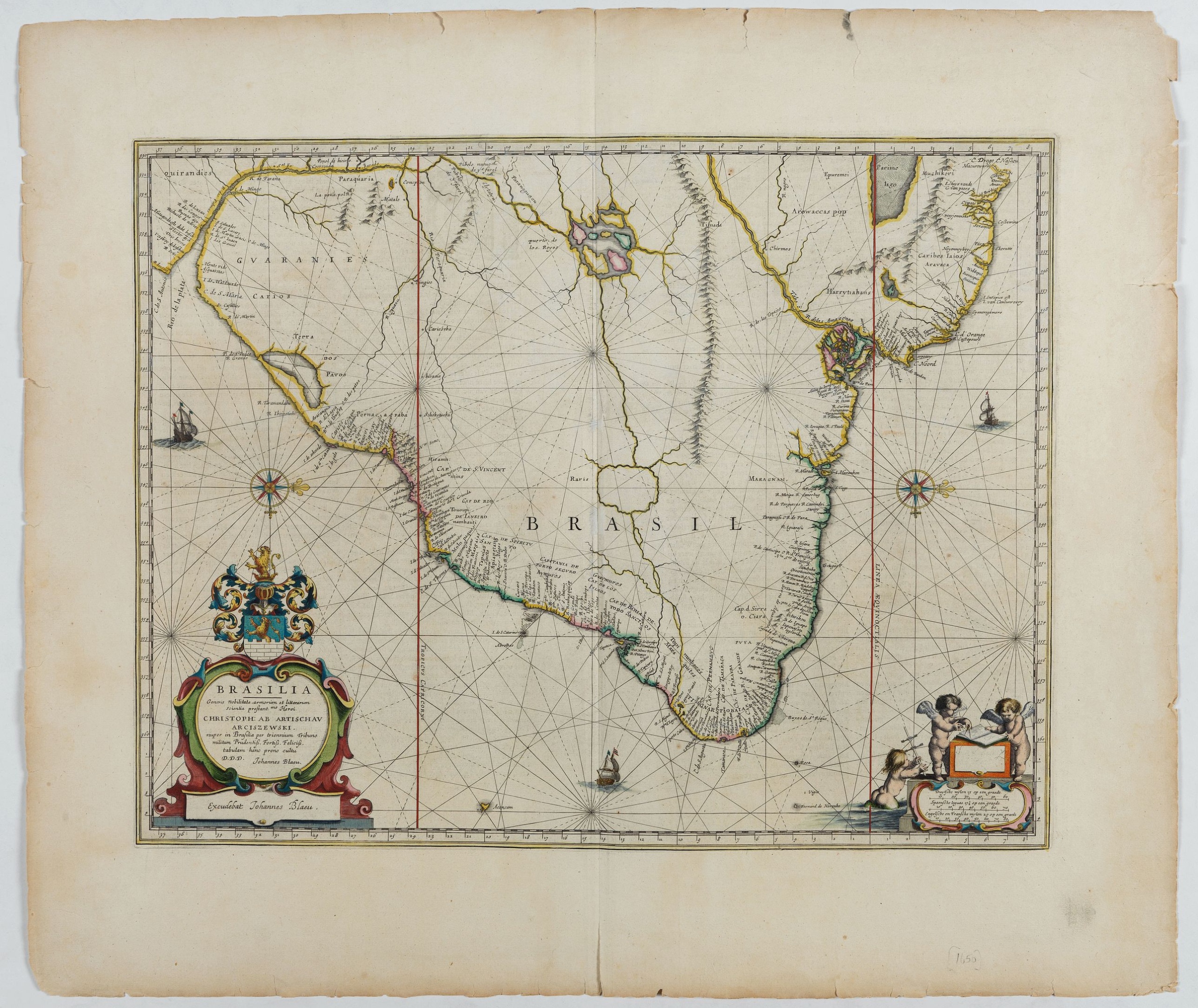
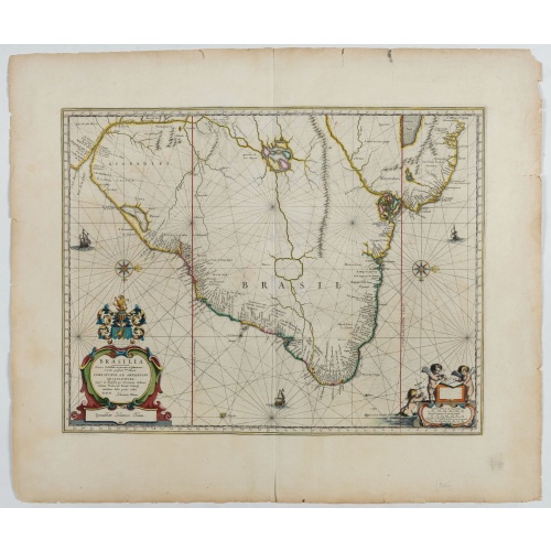
Brasilia.
BuyNow for €700
- Maker :
- BLAEU, J.
- Place :
- Amsterdam
- Date :
- 1647
- Color :
- Color printed
- Height mm.:
- 385
- Width mm.:
- 493
- Condition :
- DUTCH text on verso. Slight discoloration and a few tears in outer margins. Decorative original colours.
- Bibliography :
- Van der Krogt/ Koeman II, 9850:2B.
- Seller's ref. :
- 48497
This item is offered by Librairie_Loeb-Larocque
See other Items from this seller- Postage
-
France
€15 to France
- Select Country
- Zip/Post Code
- Quantity
€700
Description
Fine copy of this map by Krystof Arciszewski, a Polish general who worked for the Dutch West Indian Company. The map perpetuates various myths including the Parime Lago , although it is generally more accurate than its predecessors.
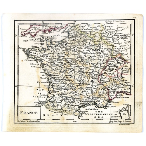
France.
Uncommon miniature map of France, engraved by J.Spilbury for "A New General and Universal Atlas Containing Forty five Maps by Andrew Dury".This miniature atlas published during the Seven Years' War.The maps are typical for the period and well executed with great clarity. The plates are engraved in 1761 and in 1763 a second edition was presumably produced for the French market having all but nine with a French titles added above the top.
€50
Maker : DURY, A. / SAYER, R. / KITCHIN, T.
Place : London
Date : 1761-1763
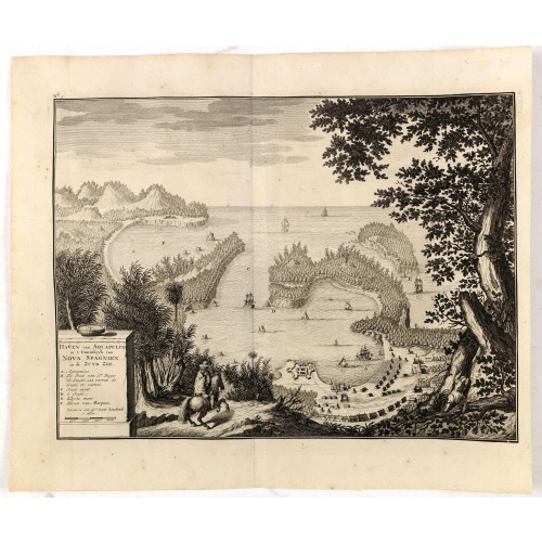
Haven van Aquapulco in ' Coninkryk van Nova Spagnien in de Zuyd Zee.
A finely engraved plan of the harbor, fort and village of Acapulco drawn from a hilltop vantage point looking out to sea. Several galleons are pictured approaching or anchored in the harbor. After Johannes Vingboons.François Valentijn (1666-1727), a missionary, worked at Amboina from 1684 to 1694 and 1705 to 1713 and traveled extensively in the VOC's lands. He is best known for his monumental history and description, "Oud en Nieuw Oost-Indiën" which remains one of the most important primary so...
€650
Maker : VALENTIJN, F.
Place : Amsterdam
Date : 1726
![De Bello Belgico decades duae ab excessu... [including lion map]](/uploads/cache/07603-500x500.jpg)
De Bello Belgico decades duae ab excessu... [including lion map]
Included in Famiani Stradae Romani è Societate Jesu de Bello Belgico Decas duae... .Published by Johann Godfried Martin Schönwetter. The book was first published in 1651 and re-published in 1699. The binding is a fine German blind-tooled pigskin, clamps wanting. Fair amount of pages has the usual browning. Copy is somewhat used but altogether very fine. Specially the folding historical engravings are of a high standard.The Bello Belgico , written by Famianus Strada (1572-1649), Jesuit and teac...
$3.500
Maker : STRADA
Place : Frankfurt am Main, Schönwetter
Date : 1699
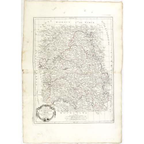
Gouvernements de Champagne et Brie.
Detailed map encompassing Champagne and Brie.Venetian edition of the map by Bonne, to whom Santini gives credit in the cartouche.From "Atlas Universel" published by Santini in 1776-84. The atlas is effectively an Italian copy of the Robert de Vaugondy 'Atlas Universel'.In 1784 Santini sold the plates to M. Remondini, whose name appears on this particular example.
€75
Maker : SANTINI, P. / REMONDINI, M.
Place : Venice
Date : 1776 - 1784
Postage & Shipping
-
Item Location
Terms and conditions - Item Location
- 75013, Ile-de-France, France
- Ships To
- United States, United Kingdom, Albania, Argentina, Armenia, Australia, Austria, Bahamas, Belgium, Bermuda, Bosnia and Herzegowina, Brazil, Bulgaria, Canada, Chile, China, Costa Rica, Denmark, Dominica, Egypt, El Salvador, Finland, France, Germany, Greece, Guatemala, Hong Kong, Hungary, Iceland, India, Italy, Japan, Korea (South), Kuwait, Liechtenstein, Lithuania, Luxembourg, Madagascar, Mexico, Monaco, Morocco, Netherlands, Netherlands Antilles, New Zealand, Norway, Paraguay, Peru, Philippines, Poland, Portugal, Qatar, Reunion, Romania, San Marino, Saudi Arabia, Seychelles, Singapore, Slovenia, South Africa, Spain, Sri Lanka, Suriname, Sweden, Switzerland, Taiwan, Thailand, Tunisia, Turkey, United Arab Emirates, Uruguay, Vietnam
- Pick-ups
- No pick-ups
This item is owned and offered by the seller Librairie_Loeb-Larocque - All items are available for immediate sale, offered subject to prior sale.
Invoices are created by the seller by using our shopping cart or be prepared by the seller the day following the order and are emailed to you.
Items offeres by different sellers are invoiced separately.
Shipping fees are extra. The buyer is responsible for all applicable taxes, including any VAT, customs clearance, import duties, or equivalent costs arriving at the customer's home border. Payment is due on receipt of the invoice. The item(s) are shipped as soon as possible after receipt of your payment.
Before buying please read the complete Terms Conditions of Sale.
- Payment Methods
- Visa, Mastercard, Bank Transfer, American Express, iDEAL, PayPal, Google Pay
- Returns Accepted
- No
Post Message
Feel free to ask the seller a question. Please note that the seller could be located in an area with a different time zone. Our seller will do their best to respond within 24 hours.Post your message below.
Sign in to ask the seller a question.