ID: 402
Open
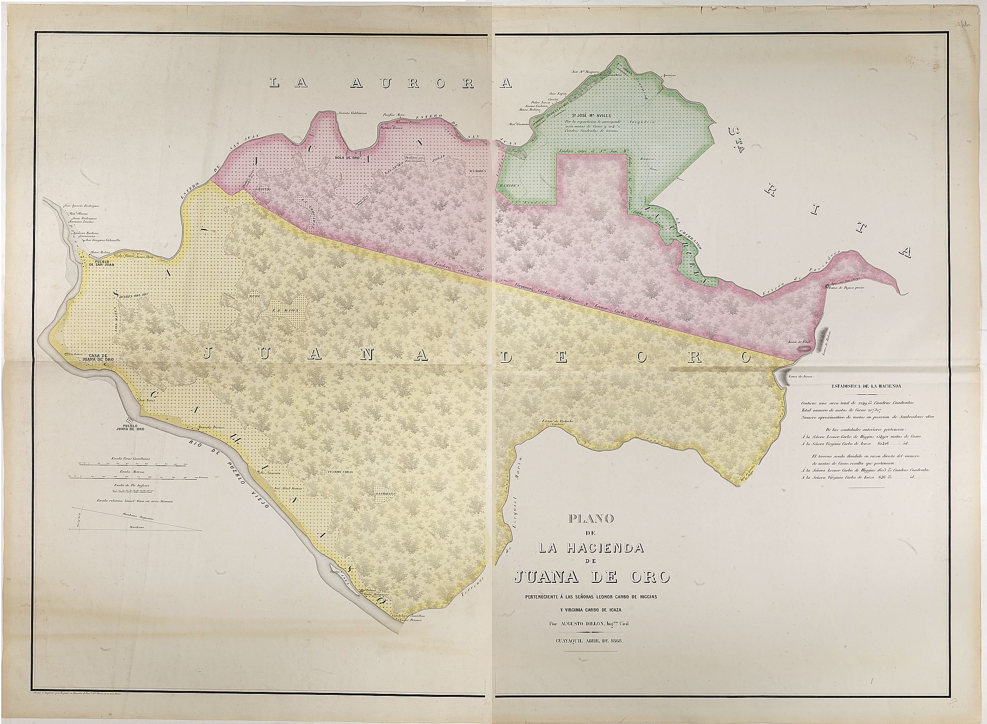
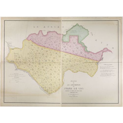
Plano de la Hacienda de Juana de Oro.
BuyNow for €750
- Maker :
- DILLON, A.
- Place :
- Guayaquil ( Equateur)
- Date :
- 1868
- Color :
- In original color
- Height mm.:
- 658
- Width mm.:
- 940
- Condition :
- Two sheet lithographed map with original hand coloring. Each sheet 658 x 940mm.
- Bibliography :
- -
- Seller's ref. :
- 29961
This item is offered by Librairie_Loeb-Larocque
See other Items from this seller- Postage
-
France
€15 to France
- Select Country
- Zip/Post Code
- Quantity
€750
Description
Wall-map sized map in 2 sheets, if joined 940 x 1300mm., showing the Hacienda (farm) of Juana de Oro in Ecuador. The cocoa farm was owned by Mrs. Leonor Carbo of Higgins and Virginia Carbo of Icaza.Cocoa plantations are depicted on the map by a multitude of shrubs. This plan provides information on cocoa productivity and distribution among the owners.

Particularitez Curieuses de l'Ile de St. Christophle et de la Province de Bemarin . . .
Six meticulously detailed and engraved scenes of the island of St. Kitts, also known as Saint Christopher, and the province of Bemarin, indigenous plants, animals, reptiles, fish, crustaceans and insects.On a single sheet from Volume Six of Chatelain's "Atlas Historique".From left to right, top, the illustrations depict the French General's palace on St. Kitts, Indians visiting the French, and a landscape in Bemarin Province. Zacharie Chatelain (d.1723) was the father of Henri Abraham (1684-1743...
€95
Maker : CHATELAIN, H.
Place : Amsterdam
Date : 1720

(Clermont, Brioude, Le Puy, etc.)
Rare miniature map including the towns of Clermont, Brioude, Le Puy, etc. From "Le theatre De Bellone, Contenant 48. nouvelles Cartes Geographiques, Des Païs-Bas Espagnols, Provinces-Unies, haute & basse Allemagne. . .". This rare atlas contained maps relating to the War of Spanish Succession. Published in Amsterdam by the widow of P. Schenk.
€60
Maker : SCHENK, P.
Place : Amsterdam
Date : 1710
![S. Victor in Franckr. [Paris].](/uploads/cache/13781-500x500.jpg)
S. Victor in Franckr. [Paris].
A very nice view of St. Victor church in Paris. In the foreground, a night watchman is depicted. With a verse in Latin and German underneath the picture. The German text reads : "Auff dass nicht mög der Wandersman, Sein Füss verletzen uff dem plan, von dem Fusseisen so merct mich, er muss wandern fursichtiglich."
€60
Maker : MEISNER, D.
Place : Frankfurt
Date : 1623-1678
Paris Superficie 5,280,000 Toises.
FIRST EDITION of this finely engraved plan of Paris by P. F. Tardieu and prepared by DuBuisson. This detailed plan of Paris includes la Place Louis XV, la Bastille, but does not have the city walls. The first edition was included in " l'Atlas nouveau" of E. Mentelle. The second state (after 1792) has the text "Plan routier de la ville de Paris…", in the righthand lettered key, added.
€600
Maker : TARDIEU, P. F.
Place : Paris
Date : 1779-1782
Postage & Shipping
-
Item Location
Terms and conditions - Item Location
- 75013, Ile-de-France, France
- Ships To
- United States, United Kingdom, Albania, Argentina, Armenia, Australia, Austria, Bahamas, Belgium, Bermuda, Bosnia and Herzegowina, Brazil, Bulgaria, Canada, Chile, China, Costa Rica, Denmark, Dominica, Egypt, El Salvador, Finland, France, Germany, Greece, Guatemala, Hong Kong, Hungary, Iceland, India, Italy, Japan, Korea (South), Kuwait, Liechtenstein, Lithuania, Luxembourg, Madagascar, Mexico, Monaco, Morocco, Netherlands, Netherlands Antilles, New Zealand, Norway, Paraguay, Peru, Philippines, Poland, Portugal, Qatar, Reunion, Romania, San Marino, Saudi Arabia, Seychelles, Singapore, Slovenia, South Africa, Spain, Sri Lanka, Suriname, Sweden, Switzerland, Taiwan, Thailand, Tunisia, Turkey, United Arab Emirates, Uruguay, Vietnam
- Pick-ups
- Buyer can pick-up
This item is owned and offered by the seller Librairie_Loeb-Larocque - All items are available for immediate sale, offered subject to prior sale.
Invoices are created by the seller by using our shopping cart or be prepared by the seller the day following the order and are emailed to you.
Items offeres by different sellers are invoiced separately.
Shipping fees are extra. The buyer is responsible for all applicable taxes, including any VAT, customs clearance, import duties, or equivalent costs arriving at the customer's home border. Payment is due on receipt of the invoice. The item(s) are shipped as soon as possible after receipt of your payment.
Before buying please read the complete Terms Conditions of Sale.
- Payment Methods
- Visa, Mastercard, Bank Transfer, American Express, iDEAL, PayPal, Google Pay
- Returns Accepted
- No
Post Message
Feel free to ask the seller a question. Please note that the seller could be located in an area with a different time zone. Our seller will do their best to respond within 24 hours.Post your message below.
Sign in to ask the seller a question.